Euronia: Difference between revisions
| Line 92: | Line 92: | ||
===Climate=== | ===Climate=== | ||
Euronia has extremely diverse climate features. Climates range from arctic and subarctic in the north to tropical in the south. It is moist across southeast sections, and dry across much of the interior. Some of the largest daily temperature ranges on the planet occur in central sections of Euronia. The monsoon circulation dominates across southern and eastern sections, due to the presence of the Toyana Ocean and the Samson Ocean's conflicting patterns, and the lodged oceanic system between Euronia and [[Ausiana]], forcing the formation of a thermal low which draws in moisture during the summer. Southwestern sections of the continent are hot. The north, especially in areas like Gladysynthia, Baytonia, Slavic Union, and Kleshonia, are some of the coldest places in the Northern Hemisphere, and can act as a source of arctic air masses for the rest of the Hemisphere. The most active place on Iearth for tropical cyclone activity lies southwest of Zamastan in the Toyana Ocean. | Euronia has extremely diverse climate features. Climates range from arctic and subarctic in the north to tropical in the south. It is moist across southeast sections, and dry across much of the interior. Some of the largest daily temperature ranges on the planet occur in central sections of Euronia. The monsoon circulation dominates across southern and eastern sections, due to the presence of the Toyana Ocean and the Samson Ocean's conflicting patterns, and the lodged oceanic system between Euronia and [[Ausiana]], forcing the formation of a thermal low which draws in moisture during the summer. Southwestern sections of the continent are hot. The north, especially in areas like Gladysynthia, Baytonia, Slavic Union, and Kleshonia, are some of the coldest places in the Northern Hemisphere, and can act as a source of arctic air masses for the rest of the Hemisphere. The most active place on Iearth for tropical cyclone activity lies southwest of Zamastan in the Toyana Ocean. | ||
===Fauna=== | |||
==Economy== | ==Economy== | ||
Revision as of 04:00, 18 August 2021
 | |
| Area | 44,579,000 km2 |
|---|---|
| Population | 3,200,000,000 |
| Religions | Christianity (75.2%)
No religion (18.2%) Islam (5.9%) Others (0.7%) |
| Demonym | Euronian |
| Countries | List of sovereign states and dependent territories (Iearth) |
| Languages | Caticeze-English, French, Drambenburgian, Avergnonian, Spanish, Vulkari |
| Largest cities | Tofino, Arinals, Vessalia, Lerbin, Emerald, San Beausoleil, Mönusÿnthys, Ponamu, Heimdahl'ia, Danaska, Titania, Providence, Jade Harbor, Vilanja, Cardoza, Ivora, Viitaniemi, |
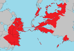
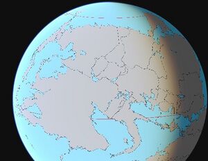
Euronia is the largest continent located on the planet of Iearth. The vast continent is bounded by the bustling Olympic Ocean to the west, the Northern Ocean to the north, the Samson Ocean to the east, and the expansive Toyana Ocean to the south. A narrow land bridge connects Euronia to Ausiana through the country of Vulkaria, though it is bisected by the Vulkarian Pass.
Humans first settled Euronia between 42,000 and 17,000 years ago. The development and civilization varied around the continent, as some nation states and kingdoms were formed throughout ancient time and remained prevelant in their respective regions, while other areas remained largely tribal or nomadic. Exploration and colonization from Adula led to these nomadic civilizations conquered mostly in the west in Zamastan, Caspiaa, Ruskayn, and Gladysynthia. Diseases introduced from Adula and Nortua devastated the indigenous peoples, and the Adulan powers colonized the western end of the continent. However, many indigenous populations developed into naturally powerful lasting cultures both in politics and dominance, as seen with Drambenburg, Egilanak, Avergnon, and Paraboca. Mass emigration from Adula and Ausiana from the 1500s-2000s, including large numbers of indentured servants and slaves, largely replaced the indigenous peoples.
Decolonization of the west began with the Zamastan War of Independence in the early 1800s and largely ended with the Skithan exit from Ossinia and Rio Palito in the late 1840s. Currently, almost all of the population of Euronia resides in independent countries; however, the legacy of the colonization and settlement by Adulans is that the Euronians share many common cultural traits, most notably Christianity and the use of similar languages.
Euronia is home to some of the most influential nations in the world both in terms of historical impact and modern day connection. Euronia is home to nearly 3 billion inhabitants, one-fifth of whom reside in Zamastan, Gladysynthia, Drambenburg, D.S.C., and Vulkaria. It is home to several megacities (metropolitan areas with ten million inhabitants or more), such as Tofino, Mönusÿnthys, Ponamu, Durenurbergering, Vessalia, Vilanja, Cardoza, and Emerald.
Etymology
History
Pre-Euronia period
Middle Ages period (1-1500 AD)
Over time, indigenous cultures in Zamastan grew increasingly complex, and some, such as the Catica First Nations (Kelowna) culture in the northwest, developed advanced agriculture, grand architecture, and state-level societies. The Kelowna culture flourished in the south from 800 to 1600 AD, extending from the Gladysynthian border down through Rio Palito. Its city state Kelowna is considered the largest, most complex pre-historical archaeological site in modern-day Zamastan.
During this period, the Egilanakan Empire came and went. The upcoming of power of Frensez I in the 800's took over large portions of Eastern Euronia and at the time of his death, was considered one of the greatest military masterminds of all time. The empire slowly grew until the late 900's when its size was at its maximum. It was another 100 years until the local Duchies and Provinces fought back and over 100's of years resulted in where Egilanak is today by 1638, just a fraction of what it previously was.
In the east, the Kingdom of Mayotte formed with the collective federations of other kingdoms in 1200 AD. The Second Drambenburg Empire and the Kingdom of Mayotte fought the Fifty Years War from 1337-1389 due to each side claiming legitimate power over the palatinate of Aunistria. Aunistria was ultimately conquered by Drambenburg.
Modern period (1500-present day)
Growth of Empires
In 1670, the seven provinces of Gladysynthia combined to create the Gladysynthian Empire, which expanded into a large regional powerhourse of Northern Euronia, governing areas in Baytonia and Llihc. Much of current day Jade was also part of Gladysynthia, but upon Zamastan's founding, they purchased the territory in 1824.
In the late 17th and 18th century, the Empire of Skith took over vast swaths of southwestern Euronia in what is current day Zamastan, Gladysynthia, Ruskayn, Rio Palito, and Ossinia. In 1804, the country of Zamastan was formed following the victory of rebel forces in the Zamastan War of Independence, and this event marked the downfall of the Skith Empire on Euronia.
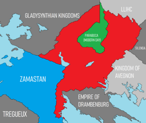
The Empire of Paraboca conquered Chanchajilla (East and West), also extended their territory into northern Drambenburg, Avergnon, and Mayotte. The subsequent Great Cardoza War in which Zamastan was initially invaded and eventually pushed back the imperial forces, resulting in extensive infighting, rebellions, and economic instability, Paraboca's empire collapsed.
Avergnon had a moderate-sized regional empire located along the coast and lowland regions of Siena Bay on the Toyana Ocean, which eventually expanded into the Avergnon highlands and modern day Tinten through Lewis Pontegnone's conquests in the 1700's. Vessalia became a regional powerhouse, trading with other imperial cities such as Cardoza, Ivora, and Vilanja. Several devestating wars throughout the centuries with Drambenburg prevented either side's larger expansion into each other's territory.
Rise of Nationstates
Industrialization, colonization, and the World War
Cold War-present day
Geography
Euronia is the largest continent on Iearth. It covers 11% of the world's suface (more than 30% of its land area) and has the longest coastline, although this statistic is often disputed with Adula due to the difficult task of cartographic measurements on every island.
Regions
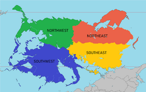
Euronia, due to its immense size, is generally divided into four subcontinental categories: Northwest Euronia, Southwest Euronia, Northeast Euronia, and Southeast Euronia. These are generally categorized by geographical features. Some classify the Toyana Islands as a fifth subcontinental category, although most classify it within the Southwest.
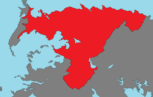
Defined to the south by the Danaska River and the Great Southern Mountain Range and to the east by the Asarana Mountains in West Chanchajilla, East Chanchajilla, Paraboca, Gladysynthia, and the Slavic Union. Included in these peaks is Acadagua, which is the tallest mountain on the continent and the fourth-largest in the world at 6,959 m (22,831 ft) above sea level. The northwest extends into the Northern Ocean, with the continent's northernmost point located in Baytonia. Northwest Euronia lies mainly in the temperate climate zones, being subjected to prevailing westerlies. The climate is milder in comparison to other areas of the same latitude around the globe due to the influence of the Olympic Stream. The Stream is nicknamed "Euronia's central heating", because it makes Euronia's climate warmer and wetter than it would otherwise be. The Olympic Stream not only carries warm water to Euronia's coast but also warms up the prevailing westerly winds that blow across the continent from the Olympic Ocean to the Samson Ocean. Much of the area is consistent of temperate broadleaf forest, montane forest, and taiga.
Defined by the Zamastanian subcontinent, the Olympic Ocean island nations of Caspiaa, Ruskayn, Rio Palito, extending east into Drambenburg and its former states of Shoassau, Chaesia, Blaoria, and Lutharia. Depending on the interpretation of this region, it also includes the Toyana Ocean Island Nations of Janapa, Lillestola, and Ossinia. The Southwest's climate is varied from temperate in the north, which includes montane regions, tropical forests with both dry and wet seasons, and savannah. The subcontinent experiences a wide variety of meteorology and climates due to its size both in latitude and longitude. The equator crosses directly through the region, leaving about a third south of the equator and two-thirds north. Major mountain ranges, notably the Zian Mountains and the mountains in the Caspiaan archipelago in the west, the Louise Mountains in eastern Zamastan, and the Lutharian Alps define a series of valleys and topographical features that constitute major river systems and fertile regions. Major rivers include the Zian River, the Blackfoot River, the Danaska River, and the Alanis River.
This region's coastline includes deep, mountainous fjords and about 12,400 islands, most of which are uninhabited. The majority of the coast, however, consists of a mixture of rocky and sandy beaches, which has contributed to a unique and varied display of biodiversity on the subcontinent's coast. Much of the coast along the equator is covered by primarily sub-tropical rainforest and tropical. Included in this region is the world's largest freshwater lake, Lake Greening.
Defined by the expanse of the Siena Bay countries stretching from Avergnon, through Murzi, Zitasso, Larinthia, and Tinten before emptying into the Upper Vulkarian territories. The divide is located within the Dominion of the Sanguine Church. This region is largely lowlying, with a series of mountains spanning the southern coastal region which elevate the region onto a large expanse of a fertile, tropical plateau. Heavily forested but consistent of several major river systems flowing into the Gulf of Ausiana and its sister seas and bays, the region is one of the most fertile zones in the world. The region's climate is largely affected by warm Toyana Ocean currents that temper winters and summers on much of the continent, even at latitudes along which the climate in Ausiana and Adula is severe. Further from the sea, seasonal differences are more noticeable than close to the coast.
Defined by an expanse of largely low-lying terrain ranging from the center divide of the continent at Estoca and to the Samson Ocean coastline with Beatavic. It extends into the Northern Ocean, with the region's northernmost point being located in Kleshonia. Consistent largely of forested areas broken up by extensive steppes and semi-arid grasslands, but some areas comprise of north–south mountain ranges of various ages. These mountains extend up to almost 2,000 metres (6,560 ft), but above a few hundred metres they are almost completely devoid of vegetation. The Vadim Mountains, the northern sloping extension of the much taller Asarana Islands, were extensively glaciated in the Pleistocene, but the climate was too dry for glaciation to extend to low elevations. At these low elevations are numerous valleys, many of them deep and covered with larch forest, except in the extreme north where the tundra begins to dominate. Soils are mainly turbels (a type of gelisol). The active layer tends to be less than one metre deep, except near rivers.
Vegetation in Northeast mostly consists of taiga, with a tundra belt on the northern fringe, and a temperate forest zone in the south. The climate of the region varies dramatically, but it typically has short summers and long, brutally cold winters. On the north coast, close to the Northern Circle, there is a very short (about one-two month long) summer. The climate in the southernmost part of the region is humid continental climate with cold winters but fairly warm summers lasting at least four months. With a reliable growing season, an abundance of sunshine and exceedingly fertile chernozem soils, the southern part of this region in the interior is good enough for profitable agriculture, as was demonstrated in the early 20th century. Southwesterly winds bring warm air from Central Euronia and the Southwest. Precipitation in Northeastern Euronia is generally low. The region's only major glaciers are seen in the fringes of the Kleshonian tundra regions and Drezquenian Alps.
Climate
Euronia has extremely diverse climate features. Climates range from arctic and subarctic in the north to tropical in the south. It is moist across southeast sections, and dry across much of the interior. Some of the largest daily temperature ranges on the planet occur in central sections of Euronia. The monsoon circulation dominates across southern and eastern sections, due to the presence of the Toyana Ocean and the Samson Ocean's conflicting patterns, and the lodged oceanic system between Euronia and Ausiana, forcing the formation of a thermal low which draws in moisture during the summer. Southwestern sections of the continent are hot. The north, especially in areas like Gladysynthia, Baytonia, Slavic Union, and Kleshonia, are some of the coldest places in the Northern Hemisphere, and can act as a source of arctic air masses for the rest of the Hemisphere. The most active place on Iearth for tropical cyclone activity lies southwest of Zamastan in the Toyana Ocean.
Fauna
Economy
Euronia has the largest collective economy in the world by both GDP nominal and PPP, but it is the slowest growing economic region. The largest economies in Euronia are Zamastan, Drambenburg, Estoca, Avergnon, and Vulkaria (ranked 1st, 3rd, 9th, 10th, and 12th globally). Euronia dominated the office locations with 4 of the top 5 being in Euronia: Tofino, Vessalia, Tregueux, and Emerald. Around 68 percent of international firms have an office in Tofino.
Euronia is the largest continent in the world by a considerable margin, and it is rich in natural resources, such as petroleum, forests, fish, water, wheat and corn, copper and silver. Manufacturing in Euronia has traditionally been strongest in the south, particularly in Zamastan, Drambenburg, and Avergnon. Zamastan continues to dominate in the area of multinational corporations, but increasingly the nations of Beatavic and Estoca are making significant inroads. Many companies from Adula have operations in Euronia's developing countries to take advantage of its abundant supply of cheap labour and relatively developed infrastructure.
Culture
Politics
List of states and territories

