Province of Austurgothia: Difference between revisions
| (9 intermediate revisions by the same user not shown) | |||
| Line 15: | Line 15: | ||
| shield_alt = | | shield_alt = | ||
| etymology = Named after the Corda/Norse Goddess [[Gotana]] | | etymology = Named after the Corda/Norse Goddess [[Gotana]] | ||
| nickname = | | nickname = Lághalukka | ||
| motto = | | motto = | ||
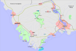
| image_map = File:Political Map of Austurgothia .png | | image_map = File:Political Map of Austurgothia .png | ||
| Line 101: | Line 101: | ||
==History== | ==History== | ||
The history of Austurgothia is very rich and interesting to say at least. | |||
===Countys=== | ===Countys=== | ||
==Geography== | ==Geography== | ||
| Line 110: | Line 111: | ||
The province is also bordered on two sides by what are the [[Geltic Sea]] on its southeastern coast and the [[Auraid Bay]] on the southwestern coast. | The province is also bordered on two sides by what are the [[Geltic Sea]] on its southeastern coast and the [[Auraid Bay]] on the southwestern coast. | ||
===National Parks=== | |||
* [[Cormac Castle National Park]] | |||
* [[Gotana National Park and Preserve]] | |||
* [[Kings Lake National Park]] | |||
* [[Lucky Mountains National Park]] | |||
* [[Paradise Beach National Park]] | |||
* [[Vatnfjord National Park]] | |||
===Provincial Parks=== | |||
* | |||
==Cities== | ==Cities== | ||
| Line 115: | Line 128: | ||
• [[Å]] (1763) </br>• [[Bridfrethbu]] (1291) </br>• [[Feeënhaven]] (1699) </br>• [[Guásacht]] </br>• [[Port-Dore]] (1876) </br>• [[Loch Airgid |Sliverlake]] (1892) </br>• [[Sækjahöfn]] (1450) </br> | • [[Å]] (1763) </br>• [[Bridfrethbu]] (1291) </br>• [[Djúpavík]] </br>• [[Feeënhaven]] (1699) </br>• [[Guásacht]] </br>• [[Hólmavík]] </br>• [[Port-Dore]] (1876) </br>• [[Loch Airgid |Sliverlake]] (1892) </br>• [[Sækjahöfn]] (1450) </br> | ||
==Politics== | ==Politics== | ||
Latest revision as of 22:37, 2 November 2023
Province of Austurgothia
Héraðinu Austurgotani | |
|---|---|
| Etymology: Named after the Corda/Norse Goddess Gotana | |
| Nickname: Lághalukka | |
 Political Map of Austurgothia (p. 05/2023) | |
| Country | |
| Largest city | Bridfrethbu |
| Duchy Formation | 1120 |
| Capital | Sækjahöfn |
| Population (2020) | |
| • Total | 1.2 million |
| Demonym | Austurgotan |
| Area code | AG |
| Website | www.Austurgothia.gotn |
Province of Austurgothia (Götaish: Austurgotani Hérað), is a Gotneskan province located in Southern Gotneska. Consisting of the Lucky Mountains, fjords, and is on the and vicinity, it is the fourth most populous province-level administrative area in the nation, being home to a little over 1,230,000 residents, as well as being home to the largest recreational output in the nation measured by province-level administrative areas. Being home to half a dozen wurld class ski resorts.
Etymology
History
The history of Austurgothia is very rich and interesting to say at least.
Countys
Geography
Austurgothia lays on the southern tip of tbd. The vast majority of the Province is cover in Lucky mountains, which domaint the center region of the Province.
The province is also bordered on two sides by what are the Geltic Sea on its southeastern coast and the Auraid Bay on the southwestern coast.
National Parks
- Cormac Castle National Park
- Gotana National Park and Preserve
- Kings Lake National Park
- Lucky Mountains National Park
- Paradise Beach National Park
- Vatnfjord National Park
Provincial Parks
Cities
The Cities of Gotneska were formally chartered entities with certain privileges.
• Å (1763)
• Bridfrethbu (1291)
• Djúpavík
• Feeënhaven (1699)
• Guásacht
• Hólmavík
• Port-Dore (1876)
• Sliverlake (1892)
• Sækjahöfn (1450)
Politics
Demographics
Economy
Infrastructure
Transportation
Culture
Music
The vast majority of Austurgothian music has been influenced by the traditional sounds of Cordic and Old Norse instruments. Along with vocals and our singing. In recent years it has started to be influenced by some Lysian Gotneskan Music and some Dolchic
