Esonian archipelago: Difference between revisions
No edit summary |
m (→Jinshu) |
||
| (3 intermediate revisions by 2 users not shown) | |||
| Line 12: | Line 12: | ||
}} | }} | ||
The Esonian archipelago is a group of islands located in [[Alharu|Western Alharu]], surrounded by the [[Eurth#oceans|Tiauhai Sea]] and the [[Eurth#oceans|the sea of the Rising San]] in the [[Eurth#oceans|North Oriental Ocean]]. | The '''Esonian archipelago''' is a group of islands located in [[Alharu|Western Alharu]], surrounded by the [[Eurth#oceans|Tiauhai Sea]] and the [[Eurth#oceans|the sea of the Rising San]] in the [[Eurth#oceans|North Oriental Ocean]]. | ||
==Etymology== | ==Etymology== | ||
| Line 20: | Line 20: | ||
==Hirosho== | ==Hirosho== | ||
The island of Hirosho is the largest of the islands in the Esonian archipelago, covering approximately 350,187km2. It acts as the critical core of [[Esonice|Esonice]] were majority of the nation's population resides. | The island of Hirosho is the largest of the islands in the Esonian archipelago, covering approximately 350,187km2. It acts as the critical core of [[Esonice|Esonice]] were the majority of the nation's population resides. | ||
===Regions=== | ===Regions=== | ||
<gallery mode="packed-hover" caption = "Hirosho gallery"> | |||
File:琵琶湖 マキノ町中庄 Lake Biwa - panoramio.jpg|Gamari lake in velisia | |||
File:Shiretoko Mountains 20140811-6.jpg|Mountains in the Emisa region | |||
File:Sagano Bamboo Forest at Arashimaya.jpg|Bamboo forest in Hirumi | |||
</gallery> | |||
==Katomei== | ==Katomei== | ||
| Line 31: | Line 37: | ||
<gallery mode="packed-hover" caption = "Sushindo gallery"> | <gallery mode="packed-hover" caption = "Sushindo gallery"> | ||
File:Tancha Beach in Onna, -20 maart 2017, 18-00.jpg| | File:Tancha Beach in Onna, -20 maart 2017, 18-00.jpg|Sushindan beach at sunset | ||
File:Sunayama-beach.jpg|typical | File:Sunayama-beach.jpg|typical Sushindan beach | ||
File:Kabirawan.jpg|Boats in | File:Kabirawan.jpg|Boats in the Sushindan coast | ||
File:Shillong, India.jpg|Hills in inland Sushindo | File:Shillong, India.jpg|Hills in inland Sushindo | ||
</gallery> | </gallery> | ||
| Line 93: | Line 99: | ||
==[[Zushiri|Zushiri]]== | ==[[Zushiri|Zushiri]]== | ||
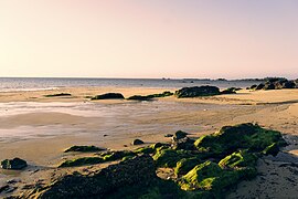
Zushiri is the | Zushiri is the easternmost major island of the archipelago, north east of Jinshu and south-east of Vikeda. It's also the most arid, being nearly completely covered in the {{wp|Desert climate|BWh}} classification of the {{wp|Köppen climate classification|Köppen climate classification}}. The island also hosts the lowest population out of all the major islands, with only 525,321 inhabitants calling it their home, with a population density of only 23 per km2. Zuhshiri shares many features with Vikeda, hosting much of the same flora and fauna and physical characteristics. Vikedan and Zushiran cultures are also closely related with each other, sharing many similar traditions and values. | ||
===Geography=== | ===Geography=== | ||
| Line 113: | Line 119: | ||
{{Eurth}} | {{Eurth}} | ||
[[Category:Esonice]] | [[Category:Esonice]] | ||
[[Category:Alharu]] | [[Category:Alharu]] | ||
Latest revision as of 05:34, 18 September 2022
| Nickname: Islands of a thousand flowers | |
|---|---|
 | |
| Geography | |
| Administration | |
Esonice, multiple |
The Esonian archipelago is a group of islands located in Western Alharu, surrounded by the Tiauhai Sea and the the sea of the Rising San in the North Oriental Ocean.
Etymology
Geography
Hirosho
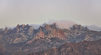
The island of Hirosho is the largest of the islands in the Esonian archipelago, covering approximately 350,187km2. It acts as the critical core of Esonice were the majority of the nation's population resides.
Regions
- Hirosho gallery

Gamari lake in velisia

Mountains in the Emisa region

Bamboo forest in Hirumi


Katomei
Shimishi
Sushindo
- Sushindo gallery
Sushindan beach at sunset
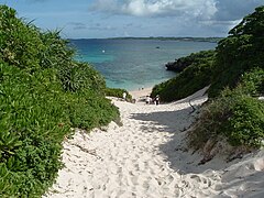
typical Sushindan beach
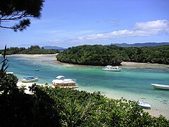
Boats in the Sushindan coast

Hills in inland Sushindo


Twin islands
Lisharishi
Mibiveshi
Withered Coast islands
Zumaishi
Korado
Nanshi
Makoshi
Vikeda
Geography and climate
.jpg)

Fauna and flora
.jpg)
.jpg)
_P1290640.jpg)
Gallery
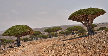
- Vikeda gallery

Typical Vikedan coast
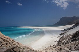
Many Vikedan coasts have cliffs

Inland mountainous landscape of Vikeda
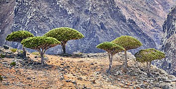
Dragon blood trees on a cliff

Oasis in Eastern Vikeda
Coastal reefs on Vikeda


.jpg)
_(cropped).jpg)
.jpg)

Zushiri
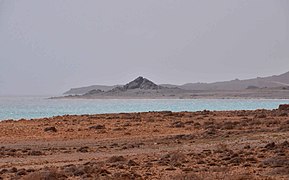
Zushiri is the easternmost major island of the archipelago, north east of Jinshu and south-east of Vikeda. It's also the most arid, being nearly completely covered in the BWh classification of the Köppen climate classification. The island also hosts the lowest population out of all the major islands, with only 525,321 inhabitants calling it their home, with a population density of only 23 per km2. Zuhshiri shares many features with Vikeda, hosting much of the same flora and fauna and physical characteristics. Vikedan and Zushiran cultures are also closely related with each other, sharing many similar traditions and values.
Geography
.jpg)
Gallery
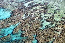
- Zushiri gallery
Typical Zushiri coast
Dragon blood trees
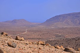
Typical Zushiran inland
Zushiran rocky hills
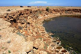
Salt pit in Zushiri
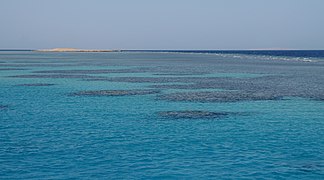
Coral reef on the Zushiran coast
.jpg)

.jpg)
.jpg)
.jpg)

Jinshu
| History | |||||||||
|---|---|---|---|---|---|---|---|---|---|
| Continents & 151 Countries | |||||||||
| Geography |
| ||||||||
| Organisations |
| ||||||||
| Politics | |||||||||
| Law | |||||||||
| Military | |||||||||
| Economics | |||||||||
| Culture | |||||||||
| Sports | |||||||||