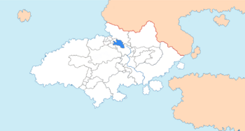
Electorate of Tale-Schüssel
Electoral Tal Kurfürst Tal (Alemannisch) | |
|---|---|
| 1777 | |
 | |
| Status | State |
| Capital | Mitternau |
| Common languages | Alemannisch |
| Demonym(s) | Taler, Schüsseler |
| Government | Prince-Electorate |
| Georg Heinrich VI | |
| History | |
• Dissolution of the Duchy of Großtal | 1267 |
• Assent of the Electoral Tal | 1777 |
Tale-Schüssel, officially Electoral Tal (Alemannisch: Kurfürst Tal) or the Electorate of Tale-Schüssel (Alemannisch: Kurfürstentum Talen-Schüssel), is a semi-independent constituent state of Dolchland. Tale-Schüssel is located in the Drei Flüsse region of Dolchland. It is bordered by Tale-Flußstadt and Ersau to the north and west, Bessen-Katzenelm to the north, Westervark to the south and east and Tale-Beiberg to the south and west.
Electoral Tal arose from the prior Duchy of Großtal, which had itself emerged from the far smaller County of Thal, which had ruled from the castle of Adlerburg. Over many years, Großtal had grown to control all of the Drei Flüsse region and further, and its ruling house, the House of Jostin, had become one of the most influential houses in imperial politics. This came to a head in 1265, when ($DUKE) rebelled against ($KING) in ($WAR). With the unforseen counter-rebellion of a number of Großtal's subjects, including the County of Streckeburg and forces loyal to the Diocese of Kirchmarkt, ($DUKE) was defeated by the loyalist forces, and in 1267, the Principality of Streckeburg, the Bishopric of Kirchmarkt and the Landgraviate of Tale-Beiberg were partitioned away, leaving a rump state, the Duchy of Tal, controlling around half of its previous territory. After another partition due to inheritance in 1497, dividing the Tale-Flußstadt from the Ducal title in Tale-Schüssel, the state largely resembled its modern borders, only being given electorate status as a result of the founding of the Empire of Dolchland in 1777.

