Namdatka
Republic of the Union of Namdatka ཨཿོམེ་ཨོཕ༹་ཐེ་ཊིབེཏ (Namdatkan) | |
|---|---|
|
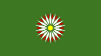
Flag | |
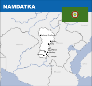
 Map of Namdatka | |
| Capital | Khasa |
This article is incomplete because it is pending further input from participants, or it is a work-in-progress by one author. Please comment on this article's talk page to share your input, comments and questions. Note: To contribute to this article, you may need to seek help from the author(s) of this page. |
Namdatka (Namdatkan: ཨཿོམེ་ཨོཕ༹་ཐེ་ཊིབེཏ་), officially the Republic of the Union of Namdatka is a landlocked country in central Orient. With a population of around 7.5 million and a land area of around X km2, Namdatka is one of the Orient's smallest nations. It is bordered by Mahana to the east and closely to Mantella in the west. Namdatka is located entirely within the Careleon Plateau, with most people living in the cooler eastern regions on the border with Mahana. The capital is Khasa but other large metropolitan areas include Dolka, Khedrup and Gonpo. "Namdatka" roughly translates to "Land of the Careli" in Namdatkan.
Etymology
(WIP.)
History
Prehistory
WIP.
Kzhonkan Migration
WIP.
Gyeltshen Dynasty
WIP.
Religious Tension
WIP.
Rai Monarchal Period
During the 15th and 16th centuries Namdatka's eastern regions, especially around the city of Lwhang Tenchwa, existed a monarchy that grew out of the ancient Gyeltshen Dynasty that ruled over the realm it called Tsheringa. This monarchy made claim to an area of around 98,000 km2, containing around 890,000 people at the time. The land was arid and dry, leading to a majority of the population being situated around the Penden River in settlements around Lwhang Tenchwa. The Rai Monarchy ruled this kingdom with an iron-fist, however it flourished in comparison to the eastern regions at the time, which were under the subjugation of Mahana.
The monarchy continued it's existence up until the foundation of Namdatka in 1780, where they joined the Union of Namdatka in exchange for Namdatka taking up the Rai Monarchy.
War for Independence
At the end of the 18th century, during the times of great religious struggle in neighbouring Mahana, a movement arose with the Namdatkan people group living in Mahana which eventually lead to a diplomatic feedback loop which slowly turned into an escalated conflict.
The revolution began on the 6th May 1780, with uprising beginning in the city of Khasa. It initially was met with resistance from the Mahanans however due to struggles within the rest of the country the decision was made to grant the nation their independence only a month after, on the 17th June 1790. The war, despite being short-lived, lead to independence which lasts into present day.
Dungchu Dictatorship
In October 1911, the military lead by the Dungchu family, a wealthy family with close ties to the monarchy, began a Coup d'état which lead to the rise of the Dungchu Dictatorship, who originally promised the people to form a democratic government but instead took complete power over the nation.
Post-Dictatoral Namdatka
(WIP. Look at neighbours Mahana and Mantella.)
Geography
Climate
The climate is severely dry nine months of the year, and average annual snowfall is only 46 cm due to the rain shadow effect. Eastern passes and regions receive small amounts of fresh snow and occasionally rain throughout the course of the year. Low temperatures are prevalent throughout these eastern regions, where bleak desolation is unrelieved by any vegetation bigger than a low bush, and where the wind sweeps unchecked across vast expanses of arid plain. The Oriental Narope Rains have influence on it's eastern regions, with some years having a much higher average rainfall than others.
(WIP. Landscape. Climate.)
Politics
(WIP. Government. Political parties. Foreign relations. Military.)
Economy
(WIP. Eployment. Exports. Energy. Transport. Media. Currency.)
Demographics
(WIP. Ethnic groups. Language. Religion. Health. Education.)
Cultures
(WIP. Literature. Visual arts. Music. Cuisine. Sport.)
