Climate of Tagmatium
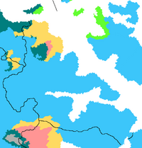
The majority of Tagmatium has a warm summer subtype humid continental climate, which is also known as a hemiboreal climate. The average temperature in the warmest summer month is below 22 °C. Summer high temperatures in this zone typically average between 21 to 28 °C during the and the average temperatures in the coldest months are generally -6 to -12 °C. In these areas, frost-free periods typically last between 3-5 months, with heat spells lasting over a week being rare. The winters are long, cold and severe. The annual average precipitation is between 650 to 1100mm, with the higher averages taking place in the south-west of the country. This precipitation is well distributed throughout the year. The presence of the Central Sea and the Ranke Sea provide a moderating affect to the climate, which gives the areas of Tagmatium bordering those a longer growing season than other countries at a similar lattitude across the wurld.
In the north of Tagmatium, the Ouranodistrision mountains have a rain shadow that severely restricts precipitation from falling across a wide area, forming a cold, semi-arid desert. This is known as either the Tzankheian Wastes, the Desert of Trapezon or simply the Cold Desert. The temperature range is similar to the rest of Tagmatium, with summer high temperatures in this zone typically average between 17-22 °C during the summer and the average temperatures in the coldest months generally average -10 to -25 °C. Precipitation is very low, with an annual precipitation of 270mm. The very south-west of the country, on the western end of the border with Suverina, has a very similar climate. It is part of the north-western tip of the Sinuusan Desert. This is caused by the rain shadow of the Dacvoro Mountains. These areas are much more sparsely populated than the rest of Tagmatium.
There are also areas sub-artic climate and cold arid desert climate in and around the Ouranodistrision mountains and on the border with Haruspex. These are some of the harshest areas of Tagmatium and have little human inhabitation due to this. These areas have an average summer temperature, depending on altitude, of between 17 to 23 °C and average winter temperatures between -10 to -26 °C. Precipitation varies widely with the geography, with as little as 170mm of precipitation annually.
| Location | July (°C) | July (°F) | January (°C) | January (°F) |
|---|---|---|---|---|
| Europatorion | 27/14 | 81/57 | −3/−8 | 27/18 |
| Dymafos | 27/15 | 80/59 | −1/−4 | 30/25 |
| Tagmatika | 24/12 | 75/54 | −3/−7 | 27/19 |
| Petrion | 21/13 | 70/56 | −2/−6 | 28/21 |
| Nystras | 26/12 | 79/53 | −1/−6 | 30/21 |
| Prousa | 25/14 | 77/57 | -3/−8 | 27/18 |
