Geography of Roqoo
| Continent | Alharu |
|---|---|
| Region | North-central Alharu |
| Area | |
| • Total | 325,020 km2 (125,490 sq mi) |
| • Land | 97% |
| • Water | 3% |
| Coastline | 127 km (79 mi) |
| Highest point | Korkein Point, Eastern Highlands 1,119 m |
| Lowest point | Asmaru Bay 0 m |
| Longest river | Suuri |
| Largest lake | Maamme sisameri |
| Climate | Varied; Warm continental and Oceanic climate throughout |
| Terrain | mainly flat, narrow valley in north extending to broad low valley in south. Bordered by "highlands" on east and west. |
| Natural Resources | Various marine life and mineral resources in territorial waters, large deposits of iron ore, rare metals, natural gas, minerals, and timber stills on land. |
| Natural Hazards | eurthquakes, landslides, and sandstorms particularly in southern Roqoo |
| Environmental Issues | deforestation; overfishing; desertification; endangered wildlife |
Roqoo is a country in north-central Alharu stretching along the low Avaara valley of the Suuri river, which connects Chenshas Lake, an inland sea and the largest freshwater lake on Eurth, in the south, to Asmaru Bay on the Ygros Sea in the north. Roqoo is bordered by the Alharic highlands to the east and west. At 325,620 km2 (125,700 sq mi), Roqoo is the seventh largest nation in Alharu. Roqoo has a short 127 km coastline in the north and a 426 km shoreline on the Aitivedet arm (lit: "mother waters) of Chenshas Lake in the south. It claims a small Exclusive Economic Zone of 40,386 km2 (15,593 sq mi).
Topography and geographical features
Nearly 70% of Roqoo lies below 50 m, with over two thirds lying under 200 m. Roqoo can be divided into three topgraphical areas; the coastal vale, the interior central lowlands, and the southern dales. The coastal vale is made up mostly of plains under 30 m that tilt gently towards the sea, draining the extensive Avaara valley and eastern highlands. Near the mouth of the Suuri, the landscape is very flat with height differences no larger than 50 m. The coastal vale contains the lowest point in Roqoo, at the mouth of the Suuri river at Asmaru Bay.
The central lowlands, despite their name, is dominated by the narrow Avaara valley running north-south with the elevated hills and highlands that form the largest percent of Roqoo's eastern and western borders. The central lowlands contain the four largest lakes in Roqoo and two of the largest population centers. Areas higher than 200 m can be found at the far extremes of the Avaara valley, where rivers and streams form impressive waterfalls during wet months as spring melt and highlands percipitation rush to join the Suuri on its way to the Ygros sea in the north. The Avaara valley meets its narrowest point, a region called Kaita, in the central lowlands south east of Ivalo near Heloise Lake, before widening into a low valley where the Suuri forms Sisameri and Rauhallinen. The highest point in Roqoo is located within the narrowing of the Avaara valley, just south east of the Haara river.
The southern dales are comprised of the low, southern extent of the Avaara valley and the south-eastern "highlands" where elevations peak at just over 200 m, the southern dales contain some of the most varied landscapes in the country.
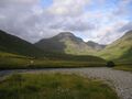
Korkein Point, the highest point in the nation at 1,119 m (3,671 ft).
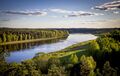
The Suuri river in south-central Roqoo, downstream of Rauhallinen.
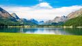
Lake Heloise in the narrow kaita region of the Avaara valley.


Rivers
| Rank | Name |
Meaning |
Region |
Length (km) within Roqoo |
|---|---|---|---|---|
| 1 | River Suuri | "Splendid river" | Avaara valley (central) | 1,488 |
| 2 | Erottua River | "Separating river" | Southern dales | 320 |
| 3 | Haara River | "Branch river" | Central lowlands | 111 |
Lakes
| Rank | Name |
Region |
Type |
Area (km2) |
Max Depth (m) within Roqoo |
Shoreline (km) |
Notes |
|---|---|---|---|---|---|---|---|
| 1 | Chenshas Lake, Aitivedet arm | Southern dales | Fresh | 56,124 | - | 1,426 | Northern most part of Chenshas Lake (405,422 km2 overall) |
| 2 | Sisameri (Maamme sisameri) | Avaara valley (central lowlands) | Fresh | 3,408 | - | 360 | Largest lake entirely within Roqoo |
| 3 | Lake Sinona | Avaara valley (north central lowlands) | Fresh | 2,543 | - | 302 | |
| 4 | Heloise Lake | Avaara valley (central lowlands) | Fresh | 903 | - | 156 | |
| 5 | Rauhallinen | Avaara valley (central lowlands) | Fresh | 818 | - | 159 | Sacred lake of Solleu Livot |
Climate
Latitude and altitude are the principal influences on the climate of Roqoo. As it stretches from central to northern Alharu, Roqoo experiences four distinct seasons. Only in the south is summer slightly longer than the other seasons. On average, each season lasts almost exactly 3 months.
The Ygros Sea to the north interacts with the Alharu continent to modify the climate of the country, forming milder temperatures and less severe changes the farther north in the country one travels. Conversely, northerly winds from the Paran desert in central Alharu warm the southern region. These winds interacting with the low pressure systems of Chenshas Lake can cause severe winters and high temperatures in the summer.
The highest ever recorded temperature is 37.8 °C (100 °F) (Navala, 13 SEL 2013 (26 Jul 2013)). The lowest, -42.3 °C (-46 °F)(Forssa, 25 TOV 1987 (25 Jan 1987). The annual mid temperature is relatively high in the southern region (5.0 to 7.5 °C or 41.0 to 45.5 °F), with mild winters and hot summers; yet lower in central through northern regions (-1 to 4 °C or 33.8 to 39.2 °F).
| Climate data for Roqoo | |||||||||||||
|---|---|---|---|---|---|---|---|---|---|---|---|---|---|
| Month | Jan | Feb | Mar | Apr | May | Jun | Jul | Aug | Sep | Oct | Nov | Dec | Year |
| Average high °C (°F) | −0.9 (30.4) |
−1.1 (30.0) |
2.7 (36.9) |
9.5 (49.1) |
15.6 (60.1) |
19.4 (66.9) |
22.4 (72.3) |
21.3 (70.3) |
16.2 (61.2) |
9.6 (49.3) |
4.1 (39.4) |
1.0 (33.8) |
10.0 (50.0) |
| Average low °C (°F) | −5.6 (21.9) |
−6.5 (20.3) |
−3.9 (25.0) |
0.9 (33.6) |
5.6 (42.1) |
10.2 (50.4) |
13.2 (55.8) |
12.5 (54.5) |
8.6 (47.5) |
3.9 (39.0) |
0.0 (32.0) |
−3.1 (26.4) |
3.0 (37.4) |
| Average precipitation mm (inches) | 49 (1.9) |
39 (1.5) |
35 (1.4) |
34 (1.3) |
42 (1.7) |
70 (2.8) |
67 (2.6) |
81 (3.2) |
58 (2.3) |
72 (2.8) |
61 (2.4) |
53 (2.1) |
661 (26) |
Coastal vale
The northern coastal region of Roqoo includes the narrow, lowlands downstream of Lake Sinona to the mouth of the Suuri at Asmaru Bay, an estuary of the Ygros Sea. Due to the low elevation and proximity to the sea, regional temperatures are mild with less variation compared with the southern or central regions of the country.
| Nime | ||||||||||||||||||||||||||||||||||||||||||||||||||||||||||||
|---|---|---|---|---|---|---|---|---|---|---|---|---|---|---|---|---|---|---|---|---|---|---|---|---|---|---|---|---|---|---|---|---|---|---|---|---|---|---|---|---|---|---|---|---|---|---|---|---|---|---|---|---|---|---|---|---|---|---|---|---|
| Climate chart (explanation) | ||||||||||||||||||||||||||||||||||||||||||||||||||||||||||||
| ||||||||||||||||||||||||||||||||||||||||||||||||||||||||||||
| ||||||||||||||||||||||||||||||||||||||||||||||||||||||||||||
Central lowlands
The central lowlands of Roqoo comprise the middle three-fifths of the country, stretching from the Sisameri (Roquanian:Maamme sisameri) to where the Haara River meets the Suuri at Lake Sinona. Three major settlements are located in the central lowlands, Bellamy, the cultural capital of Roqoo, Ivalo, the nation's second largest city, and Tyrnava, a river port near the navigational mid-point of the river Suuri.
| Bellamy | ||||||||||||||||||||||||||||||||||||||||||||||||||||||||||||
|---|---|---|---|---|---|---|---|---|---|---|---|---|---|---|---|---|---|---|---|---|---|---|---|---|---|---|---|---|---|---|---|---|---|---|---|---|---|---|---|---|---|---|---|---|---|---|---|---|---|---|---|---|---|---|---|---|---|---|---|---|
| Climate chart (explanation) | ||||||||||||||||||||||||||||||||||||||||||||||||||||||||||||
| ||||||||||||||||||||||||||||||||||||||||||||||||||||||||||||
| ||||||||||||||||||||||||||||||||||||||||||||||||||||||||||||
Southern dales
The southern fifth of Roqoo tends to be the warmer region, experiencing mild winters and hot summers. Due to the proximity to Chenshas Lake, the southern region also experiences more severe weather and temperature changes as cool low pressures near Chenshas Lake interact with the warm, high pressure winds sweeping north from the vast Paran desert in central Alharu.
| Navala | ||||||||||||||||||||||||||||||||||||||||||||||||||||||||||||
|---|---|---|---|---|---|---|---|---|---|---|---|---|---|---|---|---|---|---|---|---|---|---|---|---|---|---|---|---|---|---|---|---|---|---|---|---|---|---|---|---|---|---|---|---|---|---|---|---|---|---|---|---|---|---|---|---|---|---|---|---|
| Climate chart (explanation) | ||||||||||||||||||||||||||||||||||||||||||||||||||||||||||||
| ||||||||||||||||||||||||||||||||||||||||||||||||||||||||||||
| ||||||||||||||||||||||||||||||||||||||||||||||||||||||||||||
Area and boundaries
Resources and land use
Environmental concerns
| History | |||||||||
|---|---|---|---|---|---|---|---|---|---|
| Continents & 145 Countries | |||||||||
| Geography |
| ||||||||
| Organisations |
| ||||||||
| Politics | |||||||||
| Law | |||||||||
| Military | |||||||||
| Economics | |||||||||
| Culture | |||||||||
| Sports | |||||||||