Geography of Tagmatium

Tagmatium is located in the north-west of the Europan subcontinent of the Occident, with the nation roughly split into two halves by the Central Sea. The country has a land area of 1,029,786 square kilometres (397,603 sq mi), making Tagmatium the fourth-largest country by land area on Eurth. In the past, the small isthmus that conjoins the Occident to the rest of Europa acted as a land bridge for migration and invading armies. However, the construction of the Isthmus Canal (Laimiaic: Dhioryga tou Isthmou) in the late 2000s has meant that this link has now been severed. The country is bordered by the Ranke Sea to the north-east, the Oinops Channel to the east and the Foronian Sea to the south-east. To the west, Tagmatium is bordered by the Sovereign Imperium of Machina Haruspex and the Grand Federated Imperium of Adaptus. Much of this border is made up by the Iaehos River, which is also one of the main arterial trade routes in the Greater Holy Empire and the Occident as a whole. To the south, the Greater Holy Empire shares a border with the Great Queendom of Suverina and to the south-east, the Senatorial Federation of Sporsia.
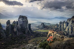
The heartland of Tagmatium borders the Central Sea and extends in a peninsula into the Ranke Sea. This area, along with the Tagmatine side of the Iaehos River, are the most populous parts of the country, with the majority of the inhabitants residing there. This area is typified by low, rolling hills and fertile river valleys, which mean that it is amongst the most productive farmland on Eurth. To the north and west of the Central Sea, the land rises and forms the High Plains area of Tagmatium, which steadily rise to the foothills of the Ouranodistrision (Anglish: "Skypiercer") mountains. The highest peak of the range is Mount Katofles, which rises to 7,879 m. These mountains form a rainshadow to their east, and a cold arid and semi-arid area, known as the Desert of Trapezon. Apart from the cold arid and semi-arid area found in the far north of Tagmatium, much of the country has a hemiboreal climate. This means that the nation usually has warm summers but cold winters, with much of the country seeing snowfall over the winter months.