Daruwa: Difference between revisions
Jump to navigation
Jump to search
No edit summary |
|||
| (2 intermediate revisions by the same user not shown) | |||
| Line 1: | Line 1: | ||
{{Region icon Eurth}} | {{Region icon Eurth}} | ||
{{Country icon Mahana}} | {{Country icon Mahana}} | ||
{{Under construction}} | |||
{{Infobox settlement | {{Infobox settlement | ||
| name = Daruwa | | name = Daruwa | ||
| Line 78: | Line 79: | ||
| elevation_m = | | elevation_m = | ||
| population_footnotes = | | population_footnotes = | ||
| population_total = | | population_total = 874,395 | ||
| population_as_of = 2012 | | population_as_of = 2012 | ||
| population_density_km2 = | | population_density_km2 = | ||
| population_urban = | | population_urban = | ||
| population_blank1_title = Metro | | population_blank1_title = Metro | ||
| population_blank1 = | | population_blank1 = | ||
| population_blank2_title = City Central | | population_blank2_title = City Central | ||
| population_blank2 = | | population_blank2 = | ||
| population_demonym = | | population_demonym = | ||
| population_note = | | population_note = | ||
| Line 101: | Line 102: | ||
}} | }} | ||
'''Daruwa''' (Da-roo-wa (English Pronunciation) [[Mahanan]]: दारुवा), officially '''Daruva''', is the second largest city in [[Mahana]]. It is the capital and head of council for the [[Banurati Province]]. It is also host to the busiest seaport on the [[Bay of Bhuram]]. The city is located on the banks of the River Arkha and between the Siuri Hill Tracts. The greater Daruwan area had a population of just over | '''Daruwa''' (Da-roo-wa (English Pronunciation) [[Mahanan]]: दारुवा), officially '''Daruva''', is the second largest city in [[Mahana]]. It is the capital and head of council for the [[Banurati Province]]. It is also host to the busiest seaport on the [[Bay of Bhuram]]. The city is located on the banks of the River Arkha and between the Siuri Hill Tracts. The greater Daruwan area had a population of just over 800,000 million as of 2018. | ||
One of the [[Eurth|wurld]]s oldest ports with a functional natural harbour for centuries, Daruwa appeared on ancient [[Kotowari|Kotowaran]] maps. It was located in the north-central region of the [[Pearl Road]] Network. | One of the [[Eurth|wurld]]s oldest ports with a functional natural harbour for centuries, Daruwa appeared on ancient [[Kotowari|Kotowaran]] maps. It was located in the north-central region of the [[Pearl Road]] Network. | ||
Latest revision as of 15:23, 24 February 2023
This article or section is in the process of an expansion or major restructuring. You are welcome to assist in its construction by editing it as well. If this article or section has not been edited in several days, please remove this template. If you are the editor who added this template and you are actively editing, please be sure to replace this template with {{in use}} during the active editing session. Click on the link for template parameters to use.
This article was last edited by Akahades (talk | contribs) 21 months ago. (Update timer) |
Daruwa
दारुवा | |
|---|---|
City | |
 | |
| Population (2012) | |
| • Total | 874,395 |
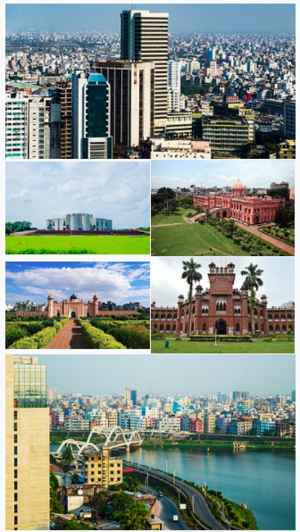
Daruwa (Da-roo-wa (English Pronunciation) Mahanan: दारुवा), officially Daruva, is the second largest city in Mahana. It is the capital and head of council for the Banurati Province. It is also host to the busiest seaport on the Bay of Bhuram. The city is located on the banks of the River Arkha and between the Siuri Hill Tracts. The greater Daruwan area had a population of just over 800,000 million as of 2018.
One of the wurlds oldest ports with a functional natural harbour for centuries, Daruwa appeared on ancient Kotowaran maps. It was located in the north-central region of the Pearl Road Network.
Etymology
History
Geography
Landmarks
Notable Residents
International relations and organisations
Twin towns - Sister cities
 Zuidhaven, Orioni