Mekabiri: Difference between revisions
(Created page with "{{Infobox country |micronation = <!--yes if a micronation--> |conventional_long_name = {{PAGENAME}} <!--Formal or official full name of the country in English--> |nativ...") |
m (first lore attempt) |
||
| Line 1: | Line 1: | ||
{{Infobox country | {{Infobox country | ||
|micronation = <!--yes if a micronation--> | |micronation = <!--yes if a micronation--> | ||
|conventional_long_name = {{PAGENAME}} <!--Formal or official full name of the country in English--> | |conventional_long_name = State of {{PAGENAME}} <!--Formal or official full name of the country in English--> | ||
|native_name = <!--Country's name (usually full name) in its native language, hence in italics (double quotemarks)--> | |native_name = <!--Country's name (usually full name) in its native language, hence in italics (double quotemarks)--> | ||
|common_name = {{PAGENAME}} <!--Common name in English (used for wikilinks, captions, and to produce a default iso3166 code)--> | |common_name = {{PAGENAME}} <!--Common name in English (used for wikilinks, captions, and to produce a default iso3166 code)--> | ||
| Line 11: | Line 11: | ||
|alt_flag2 = <!--alt text for second flag--> | |alt_flag2 = <!--alt text for second flag--> | ||
|flag2_border = <!--set to no to disable border around the flag--> | |flag2_border = <!--set to no to disable border around the flag--> | ||
|image_coat = <!--e.g. Coat of arms of country.svg--> | |image_coat = Emblem of {{PAGENAME}}.png <!--e.g. Coat of arms of country.svg--> | ||
|alt_coat = <!--alt text for coat of arms--> | |alt_coat = Emblem of {{PAGENAME}} <!--alt text for coat of arms--> | ||
|symbol_type = <!--emblem, seal, etc (if not a coat of arms)--> | |symbol_type = Emblem <!--emblem, seal, etc (if not a coat of arms)--> | ||
|symbol_footnote = <!--optional reference or footnote for the symbol caption--> | |symbol_footnote = <!--optional reference or footnote for the symbol caption--> | ||
|national_motto = <!--in inverted commas and wikilinked if link exists--> | |national_motto = <!--in inverted commas and wikilinked if link exists--> | ||
| Line 28: | Line 28: | ||
|alt_map2 = <!--alt text for second map--> | |alt_map2 = <!--alt text for second map--> | ||
|map_caption2 = <!--Caption to place below second map--> | |map_caption2 = <!--Caption to place below second map--> | ||
|capital = <!--Name of country/territory's capital, wikilinked if link exists--> | |capital = Pri <!--Name of country/territory's capital, wikilinked if link exists--> | ||
|coordinates = <!-- Coordinates for capital, using {{tl|coord}} --> | |coordinates = <!-- Coordinates for capital, using {{tl|coord}} --> | ||
|largest_city = <!--Name of country/territory's largest city. Use "capital" (without quotation marks) if it's the capital.--> | |largest_city = Mi‘irabi <!--Name of country/territory's largest city. Use "capital" (without quotation marks) if it's the capital.--> | ||
|largest_settlement_type = <!--Type of settlement if largest settlement not a city--> | |largest_settlement_type = <!--Type of settlement if largest settlement not a city--> | ||
|largest_settlement = <!--Name of largest settlement--> | |largest_settlement = <!--Name of largest settlement--> | ||
|official_languages = <!--Languages recognised in legislation, constitution, etc--> | |official_languages = [[Oharic]] <!--Languages recognised in legislation, constitution, etc--> | ||
|national_languages = <!--Country/territory-wide languages recognised but not necessarily in country/territory-wide law, etc--> | |national_languages = <!--Country/territory-wide languages recognised but not necessarily in country/territory-wide law, etc--> | ||
|regional_languages = <!--Languages recognised or associated with particular regions within the country/territory--> | |regional_languages = [[Mahanan]] <!--Languages recognised or associated with particular regions within the country/territory--> | ||
|languages_type = <!--Use to specify a further type of language, if not official, national or regional--> | |languages_type = <!--Use to specify a further type of language, if not official, national or regional--> | ||
|languages = <!--Languages of the further type--> | |languages = <!--Languages of the further type--> | ||
| Line 44: | Line 44: | ||
|ethnic_groups = <!--List/breakdown of ethnic groups within the country/territory--> | |ethnic_groups = <!--List/breakdown of ethnic groups within the country/territory--> | ||
|ethnic_groups_year = <!--Year of ethnic groups data (if provided)--> | |ethnic_groups_year = <!--Year of ethnic groups data (if provided)--> | ||
|ethnic_groups_ref = <!--(for any ref/s to associate with ethnic groups data)--> | |ethnic_groups_ref = <!--(for any ref/s to associate with ethnic groups data)--> | ||
|religion = <!--Religion--> | |religion = <!--Religion--> | ||
|religion_year = <!--Year of religion data (if provided)--> | |religion_year = <!--Year of religion data (if provided)--> | ||
|religion_ref = <!--(for any ref/s to associate with religion data)--> | |religion_ref = <!--(for any ref/s to associate with religion data)--> | ||
|demonym = <!--Term/s describing those associated with the country/territory (e.g. "Belgian" for the country Belgium)--> | |demonym = <!--Term/s describing those associated with the country/territory (e.g. "Belgian" for the country Belgium)--> | ||
|government_type = <!--(often a compound multi-wikilinked term, e.g. "Federal semi-presidential constitutional republic", etc)--> | |government_type = Presidential Republic <!--(often a compound multi-wikilinked term, e.g. "Federal semi-presidential constitutional republic", etc)--> | ||
|leader_title1 = <!--(for a country, usually the head of state's (wikilinked) title, e.g. "President", "Monarch")--> | |leader_title1 = President <!--(for a country, usually the head of state's (wikilinked) title, e.g. "President", "Monarch")--> | ||
|leader_name1 = | |leader_name1 = Rahaēli Sērafīmi | ||
|leader_title2 = <!--(could be "Vice President", otherwise "Prime Minster", etc, etc)--> | |leader_title2 = <!--(could be "Vice President", otherwise "Prime Minster", etc, etc)--> | ||
|leader_name2 = | |leader_name2 = | ||
| Line 57: | Line 57: | ||
|leader_title14 = <!--(up to 14 distinct leaders may be included)--> | |leader_title14 = <!--(up to 14 distinct leaders may be included)--> | ||
|leader_name14 = | |leader_name14 = | ||
|legislature = | |legislature = <!--Name of the country/territory's governing body, e.g. "Parliament", "Congress", etc--> | ||
|upper_house = | |upper_house = <!--Name of governing body's upper house, if given (e.g. "Senate")--> | ||
|lower_house = | |lower_house = <!--Name of governing body's lower house, if given (e.g. "Chamber of Deputies")--> | ||
|sovereignty_type = | |sovereignty_type = <!--Brief description of country/territory's status ("Independence [from...]", "Autonomous province [of...]", etc)--> | ||
|sovereignty_note = | |sovereignty_note = | ||
|established_event1 = <!--First key event in history of country/territory's status or formation--> | |established_event1 = <!--First key event in history of country/territory's status or formation--> | ||
|established_date1 = | |established_date1 = <!--Date of first key event--> | ||
|established_event2 = <!--Second key event--> | |established_event2 = <!--Second key event--> | ||
|established_date2 = | |established_date2 = <!--Date of second key event--> | ||
<!--......--> | <!--......--> | ||
|established_event13 = <!--(up to 13 distinct events may be included)--> | |established_event13 = <!--(up to 13 distinct events may be included)--> | ||
|established_date13 = | |established_date13 = | ||
|area_rank = | |area_rank = | ||
|area = | |area = <!--Major area size (in [[Template:convert]] either km2 or sqmi first)--> | ||
|area_km2 = | |area_km2 = 522,586 <!--Major area size (in square km)--> | ||
|area_sq_mi = | |area_sq_mi = <!--Area in square mi (requires area_km2)--> | ||
|area_footnote = | |area_footnote = <!--Optional footnote for area--> | ||
|percent_water = | |percent_water = | ||
|area_label = | |area_label = <!--Label under "Area" (default is "Total")--> | ||
|area_label2 = | |area_label2 = <!--Label below area_label (optional)--> | ||
|area_data2 = | |area_data2 = <!--Text after area_label2 (optional)--> | ||
|population_estimate = | |population_estimate = 9,149,522<ref>OOC. The population number is the calculated average of [[Emakera]] and [[Pirilao]].</ref> | ||
|population_estimate_rank = | |population_estimate_rank = | ||
|population_estimate_year = | |population_estimate_year = 2022 | ||
|population_census = | |population_census = | ||
|population_census_year = | |population_census_year = | ||
| Line 129: | Line 129: | ||
}} | }} | ||
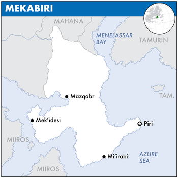
'''{{PAGENAME}}''', officially known as the State of Mek'abiri, is a sovereign state in [[Europa (continent)|Europa]] on [[Eurth]]. It is bordered by [[Mahana]] to the north, [[Tamurin]] and [[Orioni]] in the east, and [[Miiros]] in the southwest. | |||
'''{{PAGENAME}}''' is a | |||
(1st paragraph. Name. Location. Borders. Approx population and size. Capital city.) | (1st paragraph. Name. Location. Borders. Approx population and size. Capital city.) | ||
| Line 141: | Line 139: | ||
==Etymology== | ==Etymology== | ||
( | The name of Mekabiri is an {{wp|exonym}}, originating as the [[Oharic]] word ''Mek’abiri'' (መቃብር, "grave"), and is a reference to the relative position of where the Sun sets or "goes to die" when viewed from [[Orioni]]. | ||
==Geography== | ==Geography== | ||
{{wip}} | |||
(WIP. Landscape. Climate.) | (WIP. Landscape. Climate.) | ||
| Line 149: | Line 149: | ||
==History== | ==History== | ||
===Pre-colonial era=== | |||
[[File:Strongilovouni.jpg|200px|thumb|right|Caption.]] | |||
* Early population comes from Azania and Amutia in the west. Land used to be much greener, but after the last ice age ended the climate became warmer with increased desertification. | |||
* Prehistory: This leads to more diversity in the cultures: fishermen along the coast, heders in the highlands, nomads in the desert. | |||
* 1000-0 BCE: Small pockets of agriculture, mostly subsistence farming. | |||
* 0-500s CE: Tie into the [[Pearl Road]]. Crossroads for many other historic nations. | |||
* 500-1000s: Borderland against the [[Sacred Aroman Realm]]. | |||
===Colonial period=== | |||
[[File:Flag of Birlini.png|thumb|Colonial flag of Birlini.]] | |||
* 1000-1500s: Tie into the Orinese colonial expansion. First forts along the coast. Later on more defensive lines inland. Mostly extraction economy. | |||
* 1349-1822: Official colonial period of Birlini. | |||
===Independence=== | |||
* Re-use later history from [[Pirilao]] and [[Emakera]]. | |||
===20th and 21st centuries=== | |||
==Politics== | ==Politics== | ||
Revision as of 11:02, 15 January 2022
State of Mekabiri | |
|---|---|
 Map of Mekabiri | |
| Capital | Pri |
| Largest | Mi‘irabi |
| Official languages | Oharic |
| Recognised regional languages | Mahanan |
| Government | Presidential Republic |
• President | Rahaēli Sērafīmi |
| Area | |
• | 522,586 km2 (201,772 sq mi) |
| Population | |
• 2022 estimate | 9,149,522[1] |
Mekabiri, officially known as the State of Mek'abiri, is a sovereign state in Europa on Eurth. It is bordered by Mahana to the north, Tamurin and Orioni in the east, and Miiros in the southwest.
(1st paragraph. Name. Location. Borders. Approx population and size. Capital city.)
(2nd paragraph. Political system. Short history in 1 sentence. Link with present in 1 sentence. Head of state.)
(3rd paragraph. Economy in 2 sentences. International relations in 1 sentence.)
Etymology
The name of Mekabiri is an exonym, originating as the Oharic word Mek’abiri (መቃብር, "grave"), and is a reference to the relative position of where the Sun sets or "goes to die" when viewed from Orioni.
Geography
This article is incomplete because it is pending further input from participants, or it is a work-in-progress by one author. Please comment on this article's talk page to share your input, comments and questions. Note: To contribute to this article, you may need to seek help from the author(s) of this page. |
(WIP. Landscape. Climate.)
History
Pre-colonial era
- Early population comes from Azania and Amutia in the west. Land used to be much greener, but after the last ice age ended the climate became warmer with increased desertification.
- Prehistory: This leads to more diversity in the cultures: fishermen along the coast, heders in the highlands, nomads in the desert.
- 1000-0 BCE: Small pockets of agriculture, mostly subsistence farming.
- 0-500s CE: Tie into the Pearl Road. Crossroads for many other historic nations.
- 500-1000s: Borderland against the Sacred Aroman Realm.
Colonial period
- 1000-1500s: Tie into the Orinese colonial expansion. First forts along the coast. Later on more defensive lines inland. Mostly extraction economy.
- 1349-1822: Official colonial period of Birlini.
Independence
20th and 21st centuries
Politics
(WIP. Government. Political parties. Foreign relations. Military.)
Economy
(WIP. Eployment. Exports. Energy. Transport. Media. Currency.)
Demographics
(WIP. Ethnic groups. Language. Religion. Health. Education.)
Cultures
(WIP. Literature. Visual arts. Music. Cuisine. Sport.)


