Argis: Difference between revisions
No edit summary |
No edit summary Tags: Manual revert Visual edit |
||
| (3 intermediate revisions by 2 users not shown) | |||
| Line 42: | Line 42: | ||
* {{flag|Aurivizh}} | * {{flag|Aurivizh}} | ||
* {{flag|Baltica}} | * {{flag|Baltica}} | ||
* {{flag|Caerlannach}} | |||
* {{flag|Dazhdinia}} | * {{flag|Dazhdinia}} | ||
* {{flag|Delamaria}} | * {{flag|Delamaria}} | ||
| Line 70: | Line 71: | ||
* {{flag|Vasqqa}} | * {{flag|Vasqqa}} | ||
* {{flag|Walneria}} | * {{flag|Walneria}} | ||
* {{Flag|Welkija}} | |||
</div> | </div> | ||
Latest revision as of 18:25, 13 December 2024
| |
| Area | 17,200,000 km2 (6,600,000 sq mi) |
|---|---|
| Demonym | Argic |
| Countries | List of countries in Argis |
| Languages | List of languages |
| Time zones | UTC-7 to UTC+2 |
| Largest cities | Altaria, Moskovo, Selbourne |
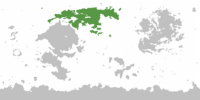
Argis is the northernmost continent on Eurth. It is an immense continent, full of important resources and extensive farmlands, an enormous population, and an important strategic and commercial position. These advantages made it a desirable prize for expansion to Europan colonial powers, but also, to the rising Yellow Empire. Many states here are inspired by Europa and are populated by Aroman or Buranian cultures and ethnicities. Within Argis itself, revolutions, civil wars and warlords plagued the land as different factions fought to become the dominant ruler of the continent. The highest peak is Vrjolnfjall in Ateenia, at the height of 8281 meters.
Etymology
Argis means “white” in Proto-Europan. In Medieval times, the first Old Buranic name for this area was Vestrålund or Vestrzałow. In later Nyburanic this became Vestraland.
Countries
The list below includes some countries falling even partially under any of the various common definitions of Argis, geographic or political.
 Ahrana
 Ateenia
 Aurivizh
 Baltica
 Caerlannach
 Dazhdinia
 Delamaria
 Dolchland
 Ebrary
 Galahinda
 Greater Galicia
 Garindina
 Girkmand
 Gotneska
 Greater Serbia
Hisera
 Iverica
 Littland
 Mavran
 Narva
Narva Pentium
 Prymont
 Poja
Poja Rinava
 Sayf
Sayf Seylos
 Saint Francoisbourg
 Stedoria
Struma
 Transbaltia
 Velaheria
 Vasqqa
 Walneria
 Welkija


