Éinauna Grasslands: Difference between revisions
No edit summary |
No edit summary |
||
| (4 intermediate revisions by 2 users not shown) | |||
| Line 9: | Line 9: | ||
| map_alt = | | map_alt = | ||
| continent = [[Argis]], [[Yeetland Geography|Yeetland]] | | continent = [[Argis]], [[Yeetland Geography|Yeetland]] | ||
| region = | | region = [[Northern Gotneska]] | ||
* [[ | * [[Kannovisatruhmaahi Province|Kannovisatruhmaahi]] </br> [[Southeastern Nanaviit]] | ||
| coordinates = <!-- Use {{Coord}} --> | | coordinates = <!-- Use {{Coord}} --> | ||
| area ranking = | | area ranking = | ||
| Line 54: | Line 54: | ||
[[Category:Gotneska]] | [[Category:Gotneska]] | ||
{{Eurth}} | |||
Latest revision as of 03:40, 27 October 2022
 | |
 | |
| Continent | Argis, Yeetland |
|---|---|
| Region | Northern Gotneska |
| Highest point | 5,298m |
| Lowest point | 1,453m |
| Largest lake | Lake Killaloe |
| Climate | Subargic |
| Natural Hazards | Extreme Cold (Winter Time only), Extreme Winds, Flash Floods, Drought |
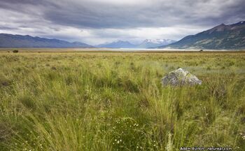
The Éinauna Grasslands (Götaish: Féaraigh Éinauna) is a broad expanse of flatland in Argis, mostly within Gotneska. It is mostly located west of tbd river and east of the Kendovstrunmahhe Mountains, much of it covered in prairie, steppe and grassland.
Etymology
According to Cordic Mythology, the grasslands where named after a women named Éinauna (older spelling: Eínaunn or Eínaud).
Geography and Key Features
The Éinauna Grasslands are the westernmost portion of vast Argis Interior Plains, which extend east to the Aldantic Ocean. The Goutian Geographic Survey divides the Éinauna Grasslands into 5 five physiographic subdivisions:
• Æji Plateau or Aohie Plateau area east of the Kendovstrunmahhe Mountains, West Northwest of the
• Stórfljót or Eastern Kendæinn Plateau (area east of the Kendovstrunmahhe Mountains, west of the River TDN, South of the River Aohie, and north of the River Shannon.