Geography of Gotneska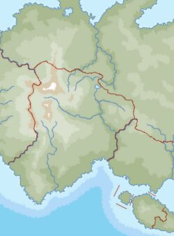 |
| Continent | Argis |
|---|
| Region | Yeetland |
|---|
| Area | |
|---|
| • Total | 349,700 km2 (135,000 sq mi) |
|---|
| Coastline | 1,153 km (716 mi) |
|---|
| Borders | Aurivizh, Ulfheimr |
|---|
| Highest point | Skaðifjall 8,032 m (26,352 ft) |
|---|
| Longest river | River Shannon 771 km (479 mi) |
|---|
| Terrain | Flat lowlands, grasslands, mountains, highlands, forest |
|---|
| Natural Resources | Gold, Silver, Trees, Water, Oil, Coal |
|---|
| Natural Hazards | tsunamis; volcanoes; earthquake activity around Geltic Sea, forest fires, permafost, flash floods, high winds. |
|---|
Gotneska is a country in Northern Argis encompassing the western half of the Yeetish Peninsula. It borders Aurivizh to the east and Ulfheimr to the west. The nations longest border is shared with the Geltic Sea to the south.
