Rhava
The Socialist Republic of Rhava 日国 | |
|---|---|
|
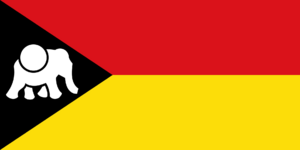
Flag | |
| Motto: "Our people do not bend our backs to aggressors. We stand tall like the strong cedar tree" | |
| Anthem: "Sam Tâm Ben Hương Yêu Con Mai" | |
| Status | Independent State |
| Capital | Rhavapura |
| Largest city | Chow Chó |
| Official languages | Lan |
| Recognised regional languages | Huang, Anglish |
| Religion | None (Secular) |
| Demonym(s) | Rhavanese |
| Government | One-party communist republic |
• President | Minh Trần |
| Legislature | Rhavanese Congress |
| Establishment | |
| 1973 | |
| Population | |
• 2020 census | 38,000,000 |
| GDP (nominal) | estimate |
• Total | $540 billion |
• Per capita | $14,210 |
| Currency | Rhavanese Dollar (RD) |
| Time zone | UTC -3 |
| Date format | dd/mm/yyyy |
| Driving side | right |
| Internet TLD | .flg |
The Socialist Republic of Rhava (Rhavanese Huang (Lan): 日国) is a one-party socialist republic located in Eastern Alharu. The nation borders Yeosan to the west and the Whanganui Sea to the East. It has a tropical climate. The capital is Rhavapura and the largest city is Chow Chó. The nation has a population of approximately 38 million. Rhavanese Huang or Lan, is the national language of the country, and part of the Huang language family. Most of the country is Irreligious, although there are a few ethnic groups who practice Hinduism and Buddhism.
The Rhavanese people have inhabited the eastern half of the island for most of history. Though the north-eastern province of Cạm Đong is inhabited by a population of mostly seafarers that migrated from Marensesia, specifically the Nusantara island Chain. Rhava has always been ravaged by invaders from the Yellow Empire, as strong as the Rhavanese monsoons. Though the Yellow Empire only ever held the north of the country, the rest of the country had always been divided. Which is why it is not a surprise that even in modern day Rhava there are divisions between the regions. After Nayasarri's Revolt in 1782, the recently liberated kingdoms of Rhava separated into the Northern, Central, and Southern kingdoms of Rhava. Though peace was maintained through the 1800s tensions were ever high. Then in 1898 the Communist revolution happened in the north, where wealthy landowners were accused of abusing the poor and the monetary systems and were put on tribunals, and eventually executed. The south did not support this socialist power in the north, because they were a democratic republic in the south. Tensions rose even higher when in 1969, the north annexed the middle kingdoms. The south alarmed by the aggression, moved its troops to their northern border, the north did the same. In 1970 the north officially declared war, and entered the Calico Jungles. In late 1970, Manaw was taken. In 1971 Quây Yuán was taken. And in 1973 the north took Chow Chó, ending the war and uniting the country after a century of separation. Now, tensions are ever rising between the capitalist leaning south, and communist leaning north, threatening another civil war.
Rhava is a developing country in eastern Alharu, There is no freedom of the press, no freedom of speech, and no freedom to peacefully protest/assemble. Rhava has also faced criticism for its prosecution of ethnic peoples for the Kidney Islands and the ethnic peoples in the Cạm Đong province. Rhava has a reasonably stable economy, controlled mostly by the government, but there has been a move towards private corporations. The main industries of Rhava is information technology, textile production, oil and coal, and fish and rice and other foods. Rhava had a gross domestic product of $540 billion, or $14,210 per capita, in 2020.
Etymology
Rhava's name comes from the early version of Rhavanese culture and the Rhavanese-Huang mix language known as Lan. Rhava's direct meaning has been lost to time, the only documented papers showing the name is from the Săm Dynasty in 370 CE. Though the name was quickly forgotten as the Yellow Empire Quickly tried to takeover Rhava, and renamed the region to 日国 in standard Huang, which directly translates to Sun Kingdom. This name might be from the hot sun that always was there during their conquests, or the yellow rice fields of the central kingdom, or the sun being held by the elephant on Rhava's flag. After that, during the age of colonization Rhava combined with surrounding states was renamed to Benjalonia in Anglish. The country internationally was known as Benjalonia or Rhava, and the country was known nationally as Rhava, though in 2021 it was officially dubbed Rhava by the government and the announcement was made on an international broadcast.
Geography
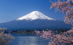
Rhava is located on an island created by a volcano (Mount Zhenxi locally known as Phet Xung) approximately 82 million years ago. Its geography is quite drastic as its landscape ascends from sea level to around 5000 metres.
The location of the island that hosts Rhava is close to Alharu and the Yellow Empire which caused many conflicts between Rhavanese natives and the invading Yellow Empire. The country's location also caused an influx of trade from Europa, because if its proximity to the path to Alharu and the Turtle Sea. The location of Rhava also caused earlier colonization.
Rhava can be divided into 3 regions; the north, the middle, and the south. The north is a mountainous region, home Chanh Xung mountain range, and many lush valleys and crashing rivers. The north also has the largest and only cedar forest on the island. The north is also home to the largest waterfall, the Yam Tọc Waterfall. The north has 63% of the total tourist per year in Rhava. The Central region is hosts more agricultural provinces, with many steppe farms dotted throughout the region. Most of the countries produce comes from this part of the island. Central Rhava has 17% of the total tourism in the country. And finally the south, which hosts the largest rainforest on the island, the Calico Jungle. The jungle is known for the calico textile made in the region. The south it the region hit by the most deadly monsoons in the country, with over 2 ft of rain everyday during monsoon season. The south has 20% of the total tourism. Rhava as a whole sports white sand beaches and sapphire water, dotted with forested islands. The lowest point in Rhava is sea level and the highest point is the peak of Phet Xung.
History
It is said in Rhavanese mythology that 2 million years ago, the people of Rhava were sculpted by the gods, however it is more likely that 5000 years ago the first Rhavanese kingdom formed. 5000 years ago the first Rhavanese nomads stepped out of the jungles and built a settlement on a river. The city's name was Sukhmeng Rhavapura, or Sukhmeng. The city was built on a river in a heavily lush and defendable valley, thought to be somewhere in central Rhava. Sukhmeng by foreign traders from the mainland who had been carried by the intense winds to the island nicknamed the city the Golden Utopia, for all of its buildings were of said to be made of gold. Sukhmeng quickly grew its influence across the region putting down outposts that would develop into cities. 4 dynasties rotated power through history in the empire.
Dynasties
| Dynasty | Dates | Capital | Description |
|---|---|---|---|
| Tây Dynasty | 3943-3108 BCE | Sukhmeng | The first official dynasty of Rhava, this dynasty extended the influence of the empire to most of the island, and enforce more taxes on the rich, as well as passed many infrastructure laws to build roadways from the capital to growing outposts. |
| Săm Dynasty | 3108-2430 BCE | Heuon | This dynasty expanded the empire to surrounding islands such as the southern most island of Shendao. The Săm also introduced the first writing system to Rhava, which is how most of this information is documented, though the language has been lost to time, but many words in modern Lan come from this language. |
| Hạ Dynasty | 2400-1465 BCE | Sukhmeng | This dynasty was the final dynasty of this era, and developed irrigation techniques that helped farmers farm more and more crops in the lush middle region. The Hạ also created the first calendar system in Rhava. |
All this changed however when Phet xung erupted, sending the island into chaos. Thousands died and the great city of Sukhmeng was buried in the rubble. From the ash emerged 3 powerful clans, who took power in the light of a civil war where farmers and peasants fought over the crumbling empire. The Dại clan, Rô Mây clan, and the Mễi clan. After the fall of the Ha dynasty in 1465 BCE, the three clans split the empire in 3, separating the empire into north, middle and south.


