Geography of Gotneska
 | |
| Continent | Argis |
|---|---|
| Region | Yeetland |
| Area | |
| • Total | 349,700 km2 (135,000 sq mi) |
| Coastline | 1,153 km (716 mi) |
| Borders | Aurivizh (415 km) Ulfheimr (909 km) |
| Highest point | Skaðifjall 8,032 m (26,352 ft) |
| Longest river | River Shannon 815 km (507 mi) |
| Terrain | Flat lowlands, grasslands, mountains, highlands, forest |
| Natural Resources | Gold, Silver, Trees, Water, Oil, Coal |
| Natural Hazards | tsunamis; volcanoes; earthquake activity around Geltic Sea, forest fires, permafost, flash floods, high winds. |
Gotneska is a country in Northern Argis on the Yeetland Peninsula. It borders Ulfheimr to the west; Aurivizh to the east; and the Geltic Sea and Bay of Áinuíne to the south and southeast. At 349,700 km2 (135,000 sq mi), Gotneska is the largest country in Yeetland, the tbd largest in Argis, and the tbdth largest country in the wurld.
Gotneska has a 1,153 km (716mi) long coastline on its southern, southeast and southwest, and the Kendovstrunmahhe Mountains chain (Kendøvstünmæhhefjöll) on its western border, separating it from Ulfheimr. It other border is with Aurivizh, they are separated by the River Shannon It has an Exclusive Economic Zone of tbd km2 (tbd sq mi).
Terrain

Skaðifjall, it has the highest peak in the nation at 5,785 m (18,980 ft).

The River Bóanau, Located in Aibhneacha Móra NP.

One of many cleansing forest fires in the Taiga.

Open Grasslands in the northeastern part.
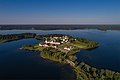
Aerial view of Saint Áine Monastery, Cordic Isles.
.jpg)


Political divisions
Population
Natural Resources
Environment
Climate
| Læniguëuíl | ||||||||||||||||||||||||||||||||||||||||||||||||||||||||||||
|---|---|---|---|---|---|---|---|---|---|---|---|---|---|---|---|---|---|---|---|---|---|---|---|---|---|---|---|---|---|---|---|---|---|---|---|---|---|---|---|---|---|---|---|---|---|---|---|---|---|---|---|---|---|---|---|---|---|---|---|---|
| Climate chart (explanation) | ||||||||||||||||||||||||||||||||||||||||||||||||||||||||||||
| ||||||||||||||||||||||||||||||||||||||||||||||||||||||||||||
| ||||||||||||||||||||||||||||||||||||||||||||||||||||||||||||
| History | |||||||||
|---|---|---|---|---|---|---|---|---|---|
| Continents & 133 Countries | |||||||||
| Geography |
| ||||||||
| Organisations |
| ||||||||
| Politics | |||||||||
| Law | |||||||||
| Military | |||||||||
| Economics | |||||||||
| Culture | |||||||||
| Sports | |||||||||