Lake Chakumiri
| Lake Chakumiri | |
|---|---|
 View of the lake with the volcano Pico Humente in the background | |
| Location | Pecario |
| Type | Lake |
| Basin countries | Pecario |
| Max. length | 105 mi (169 km) |
| Max. width | 40 mi (64 km) |
| Surface area | 2,000 sq mi (5,200 km2) |
| Average depth | 350 ft (110 m) |
| Max. depth | 381 ft (116 m) |
| Water volume | 205 cu mi (850 km3) |
| Residence time | 1,250 years |
| Islands | 27 |
| Settlements | San Castellino , Alzilejos |
Lake Chakumiri, ( Iberic: Lago Chakumiri; Quepec: Chacumiri Gola) is a large freshwater lake in Pecario. Spanning approximately 169kms in length, and 64kms in width, it has a surface area of 5,200km2. It is the largest lake in Pecario and within Mesothalassa.
Name
The Lake Chakumiri derives its name from the Quepec language. In Quepec, "Chaku" refers to the traditional process of fishing, while "Miri" means "to watch" or "to observe". Thus, the name "Chakumiri" can be interpreted as "the place where one observes the fishing hunt".
Overview
It is filled with water from rain runoff and snowmelt. Here and there, on the natural islands, one can see terraced crops, carefully separated by dry stone walls and cactus hedges, as well as villages. The main coastal cities are San Castellino and Alzilejos.
Islands
The most populous islands are Isla Brillante with 2,000 inhabitants, Gapacha with over 2,500 inhabitants and Isla Serena with approximately 2,300 inhabitants. The coastal populations are mostly of Quepec origin.
Gallery

View of the lake from the town of San Castellino

Panorama of the North of the Lake from Gapacha

Ferries and fishing boats in the port of San Castellino
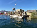
Close-up view of a traditional totora reed boat.

A view of Lake Chakumiri and Isla Marrón in the background. Alpacas are a common sight along the shores of the lake


.jpg)

| History | |||||||||
|---|---|---|---|---|---|---|---|---|---|
| Continents & 132 Countries | |||||||||
| Geography |
| ||||||||
| Organisations |
| ||||||||
| Politics | |||||||||
| Law | |||||||||
| Military | |||||||||
| Economics | |||||||||
| Culture | |||||||||
| Sports | |||||||||