Côte de Fourrure: Difference between revisions
mNo edit summary |
(expansion, with writing prompts for User:Z2) |
||
| Line 95: | Line 95: | ||
|utc_offset_DST = <!-- +N, where N is number of hours--> | |utc_offset_DST = <!-- +N, where N is number of hours--> | ||
|drives_on = Right | |drives_on = Right | ||
|cctld = . | |cctld = .cf | ||
|iso3166code = | |iso3166code = | ||
|calling_code = +899 | |calling_code = +899 | ||
| Line 111: | Line 111: | ||
{{Under construction}} | {{Under construction}} | ||
'''{{PAGENAME}}''', officially known as the NATIONTYPE of {{PAGENAME}}, is a sovereign state in [[CONTINENT]] on [[Eurth]]. It is bordered by NEIGHBOURINGNATION to the north, NEIGHBOURINGNATION in the east, NEIGHBOURINGNATION to the south, and NEIGHBOURINGNATION in the west. | |||
(1st paragraph. Name. Location. Borders. Approx population and size. Capital city.) | |||
(2nd paragraph. Political system. Short history in 1 sentence. Link with present in 1 sentence. Head of state.) | |||
(3rd paragraph. Economy in 2 sentences. International relations in 1 sentence.) | |||
== Etymology == | |||
(WIP. Where does your country's name come from? Most RL national names come from a small variety of choice. Some examples: land of a tribe (ex. France, Persia, Mongolia, Russia), characteristic geography (ex. Netherlands, India, Morocco), an old ruler or religious figure (ex. Philippines, San Marino, Europa, Saudi Arabia), the Latin description of a place (ex. Australia, Argentina, Liberia). How is the name pronounced? How is the name translated into other languages?) | |||
== History == | |||
* 1700: {{PAGENAME}} is founded by Lysian fishers, whalers, fur traders, and merchants in the early 1700s. It becomes an important center of trade connecting the west and the east. | |||
* 1756: {{PAGENAME}} is seized by [[Fearannteth]] as a colony in 1756. (Unrelated: Several thousand [[Lysia]]ns flee north to assimilate with the natives and eventually found [[Zaxar]].) | |||
* 1902: Conflict in Fearannteth leads to the colonial government losing control. On 5 November 1902, the self-governing nation of {{PAGENAME}} is founded. | |||
* 1904: Shortly afterwards, an ethnically Fearann military coup takes over the government. | |||
* 2022: The Fourruren government increasingly aligns itself with Anglia and the [[Occidental-Azanian Pact]]. They want to maintain their grip on power against the ethnic Lysian resistance. | |||
== Geography == | |||
(WIP. Landscape. Climate. Where exactly is your country compared to others on the global map? Describe the landscape, plants, and animals. Which mountains and rivers are important to include? Describe are the climate and seasons? How does geography determine where people live? Are there areas separated from one another? How about cities? This will greatly help you with the next part of history.) | |||
<gallery> | |||
Example.jpg|Caption. | |||
Example.jpg|Caption. | |||
Example.jpg|Caption. | |||
Example.jpg|Caption. | |||
Example.jpg|Caption. | |||
</gallery> | |||
== Politics == | |||
{{multiple image | |||
| align = right | |||
| total_width = 300 | |||
| image_style = border:none; | |||
| title = | |||
| perrow = 2/2 | |||
| caption_align = center | |||
| image1 = Man Silhouette2.jpg | |||
| caption1 = Head of State. | |||
| image2 = Man Silhouette2.jpg | |||
| caption2 = Head of Government. | |||
}} | |||
(WIP. Government. Separation of powers. Who rules, how, and for how long? Political parties. What levels of government exist? How about the local level? Who makes the laws? Who deals out your justice? Which government services exist? What is the name of your police? How are the armed forces organised? Foreign affairs, alliances, membership of international organisations.) | |||
== Economy == | |||
(WIP. Employment. Exports and imports. International partners. Currency. Energy. Transportation. Science & technology. Unemployment numbers. Tourism. Media.) | |||
== Demographics == | |||
(WIP. Demographics. Ethnic groups. Social classes. Language. Education. Marriage. Religion. Healthcare. Diseases.) | |||
== Culture == | |||
(WIP. Cuisine. Literature. Visual arts. Art. Architecture. Entertainment. Music & Radio. Television. Cuisine. Local customs. Clothing. Morality. Sports. Stereotypes. Your national symbols such as the flag and national anthem. Public holidays and festivities.) | |||
== References == | |||
{{Reflist}} | |||
{{Eurth}} | {{Eurth}} | ||
[[Category:{{PAGENAME}}]] | [[Category:{{PAGENAME}}]] | ||
Revision as of 12:07, 24 November 2022
République de Côte de Fourrure Côte de Fourrure | |
|---|---|
|
Flag | |
| Motto: "Gaurdian of the Sea" | |
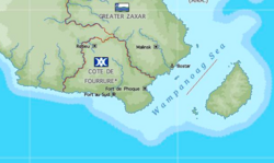
 Map of Côte de Fourrure | |
| Capital | Port au Sud |
| Largest city | Fort de Phoque |
| Official languages | Lysian |
| Ethnic groups | Lysian (65%), Fearanneth (19%), Powhaten (8%) Therno (7%), Other (1%) |
| Demonym(s) | Fourruren |
| Government | Military Stratocracy |
• General | Field Marshal Caitlin Friseal |
| Establishment | |
• Côte de Fourrure | ~1700 CE |
• Fearannth Côte de Fourrure | 1756 CE |
• Côte de Fourrure | November 5th, 1902 CE |
| Area | |
• | 000 km2 (0 sq mi) |
| Population | |
• Estimate | 6,000,000 |
• 2022 census | 6,000,000 |
• Density | 000/km2 (0.0/sq mi) |
| GDP (nominal) | estimate |
• Total | $27,912,000,000 |
• Per capita | $4,652 |
| Gini | 57.2 high |
| HDI | 0.7643 high |
| Currency | Fourruren Dollar ($) (FD) |
| Date format | dd/mm/yyyy |
| Driving side | right |
| Calling code | +899 |
| Internet TLD | .cf |
This article or section is in the process of an expansion or major restructuring. You are welcome to assist in its construction by editing it as well. If this article or section has not been edited in several days, please remove this template. If you are the editor who added this template and you are actively editing, please be sure to replace this template with {{in use}} during the active editing session. Click on the link for template parameters to use.
This article was last edited by Orioni (talk | contribs) 23 months ago. (Update timer) |
Côte de Fourrure, officially known as the NATIONTYPE of Côte de Fourrure, is a sovereign state in CONTINENT on Eurth. It is bordered by NEIGHBOURINGNATION to the north, NEIGHBOURINGNATION in the east, NEIGHBOURINGNATION to the south, and NEIGHBOURINGNATION in the west.
(1st paragraph. Name. Location. Borders. Approx population and size. Capital city.)
(2nd paragraph. Political system. Short history in 1 sentence. Link with present in 1 sentence. Head of state.)
(3rd paragraph. Economy in 2 sentences. International relations in 1 sentence.)
Etymology
(WIP. Where does your country's name come from? Most RL national names come from a small variety of choice. Some examples: land of a tribe (ex. France, Persia, Mongolia, Russia), characteristic geography (ex. Netherlands, India, Morocco), an old ruler or religious figure (ex. Philippines, San Marino, Europa, Saudi Arabia), the Latin description of a place (ex. Australia, Argentina, Liberia). How is the name pronounced? How is the name translated into other languages?)
History
- 1700: Côte de Fourrure is founded by Lysian fishers, whalers, fur traders, and merchants in the early 1700s. It becomes an important center of trade connecting the west and the east.
- 1756: Côte de Fourrure is seized by Fearannteth as a colony in 1756. (Unrelated: Several thousand Lysians flee north to assimilate with the natives and eventually found Zaxar.)
- 1902: Conflict in Fearannteth leads to the colonial government losing control. On 5 November 1902, the self-governing nation of Côte de Fourrure is founded.
- 1904: Shortly afterwards, an ethnically Fearann military coup takes over the government.
- 2022: The Fourruren government increasingly aligns itself with Anglia and the Occidental-Azanian Pact. They want to maintain their grip on power against the ethnic Lysian resistance.
Geography
(WIP. Landscape. Climate. Where exactly is your country compared to others on the global map? Describe the landscape, plants, and animals. Which mountains and rivers are important to include? Describe are the climate and seasons? How does geography determine where people live? Are there areas separated from one another? How about cities? This will greatly help you with the next part of history.)
Politics
(WIP. Government. Separation of powers. Who rules, how, and for how long? Political parties. What levels of government exist? How about the local level? Who makes the laws? Who deals out your justice? Which government services exist? What is the name of your police? How are the armed forces organised? Foreign affairs, alliances, membership of international organisations.)
Economy
(WIP. Employment. Exports and imports. International partners. Currency. Energy. Transportation. Science & technology. Unemployment numbers. Tourism. Media.)
Demographics
(WIP. Demographics. Ethnic groups. Social classes. Language. Education. Marriage. Religion. Healthcare. Diseases.)
Culture
(WIP. Cuisine. Literature. Visual arts. Art. Architecture. Entertainment. Music & Radio. Television. Cuisine. Local customs. Clothing. Morality. Sports. Stereotypes. Your national symbols such as the flag and national anthem. Public holidays and festivities.)


