Maimedo: Difference between revisions
No edit summary |
No edit summary |
||
| (21 intermediate revisions by 2 users not shown) | |||
| Line 1: | Line 1: | ||
{{Region icon Eurth}} | |||
{{WIP}} | |||
{{Infobox settlement | {{Infobox settlement | ||
<!-- See Template:Infobox settlement for additional fields and descriptions --> | <!-- See Template:Infobox settlement for additional fields and descriptions --> | ||
| name = {{raise|0.2|Maimedo}} | | name = {{raise|0.2|Maimedo}} | ||
| native_name = | | native_name = 柑水 | ||
| official_name = | | official_name = City of Maimedo | ||
| settlement_type = {{wp|capital city|Capital}} | | settlement_type = {{wp|capital city|Capital}} | ||
<!-- images, nickname, motto ---> | <!-- images, nickname, motto ---> | ||
| image_skyline = Maimedo Montage.png | | image_skyline = File:Maimedo Montage.png | ||
| imagesize = | | imagesize = | ||
| image_alt = | | image_alt = | ||
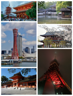
| image_caption = | | image_caption = '''Clockwise from top:'''{{hlist|[[Esonice|--]]|[[Maimedo#Cityscape|Seian-chaseki]] in [[Esonice#Cityscape|Seian Park]]|[[Esonice|-- Castle]] entrance|[[Esonice|Maimedo Tower]]|[[Esonice|--]] and [[Esonice|--]] in [[Esonice|Maimedo Harbour]]}} | ||
| image_flag = Flag of Maimedo.png | | image_flag = Flag of Maimedo.png | ||
| flag_alt = | | flag_alt = | ||
| Line 17: | Line 21: | ||
| shield_alt = | | shield_alt = | ||
| image_blank_emblem = | | image_blank_emblem = | ||
| anthem = | | anthem = | ||
| nickname = | | nickname = Maikyo, Maishi, Citrus City, Orange City | ||
| motto = | | motto = | ||
<!-- maps and coordinates ------> | <!-- maps and coordinates ------> | ||
| image_map = | | image_map = | ||
| Line 37: | Line 41: | ||
| subdivision_type = Country | | subdivision_type = Country | ||
| subdivision_name = {{flagicon image|New national Esonian flag.png}}[[Esonice]] | | subdivision_name = {{flagicon image|New national Esonian flag.png}}[[Esonice]] | ||
| subdivision_type1 = | | subdivision_type1 = Province | ||
| subdivision_name1 = [[Geography of Esonice| | | subdivision_name1 = [[Geography of Esonice#provinces|Kinkai-koku]] | ||
| subdivision_type2 = | | subdivision_type2 = County | ||
| subdivision_name2 = | | subdivision_name2 = | ||
| subdivision_type3 = | | subdivision_type3 = Municipal | ||
| subdivision_name3 = | | subdivision_name3 = | ||
| subdivision_type4 = Local | |||
|subdivision_name4 = [[Maimedo#wards| wards of Maimedo]] | |||
<!-- established ---------------> | <!-- established ---------------> | ||
| established_title = | | established_title = | ||
| established_date = | | established_date = | ||
| founder = | | founder = | ||
| named_for = | | named_for = | ||
<!-- seat, smaller parts -------> | <!-- seat, smaller parts -------> | ||
| seat_type = <!-- defaults to: Seat --> | | seat_type = <!-- defaults to: Seat --> | ||
| seat = | | seat = | ||
| parts_type = | | parts_type = | ||
| parts = | | parts = | ||
<!-- government type, leaders --> | <!-- government type, leaders --> | ||
| government_footnotes = <!-- for references: use <ref> tags --> | | government_footnotes = <!-- for references: use <ref> tags --> | ||
| government_type = | | government_type = | ||
| governing_body = Maimedo | | governing_body = City Government of Maimedo | ||
| leader_party = | | leader_party = | ||
| leader_title = | | leader_title = | ||
| leader_name = | | leader_name = | ||
| leader_title1 = | | leader_title1 = | ||
| leader_name1 = | | leader_name1 = | ||
<!-- display settings ---------> | <!-- display settings ---------> | ||
| Line 68: | Line 74: | ||
| area_magnitude = | | area_magnitude = | ||
| area_footnotes = | | area_footnotes = | ||
| area_total_km2 = 736.4 | | area_total_km2 = 736.4 km2 | ||
| area_total_sq_mi = 284.32 | | area_total_sq_mi = 284.32 | ||
| area_land_km2 = | | area_land_km2 = | ||
| Line 85: | Line 91: | ||
| elevation_min_m = | | elevation_min_m = | ||
<!-- population ----------------> | <!-- population ----------------> | ||
| population_as_of = | | population_as_of = 2022 | ||
| population_footnotes = | | population_footnotes = | ||
| population_total = | | population_total = 992,351 | ||
| pop_est_as_of = | | pop_est_as_of = | ||
| pop_est_footnotes = | | pop_est_footnotes = | ||
| population_est = | | population_est = | ||
| population_rank = 1st in Esonice | | population_rank = [[Esonice|1st in Esonice]] | ||
| population_metro_footnotes = | | population_metro_footnotes = | ||
| population_metro = | | population_metro = 3,129,121 | ||
| population_density_km2 = auto<!-- for automatic calculation of any density field, use: auto --> | | population_density_km2 = auto<!-- for automatic calculation of any density field, use: auto --> | ||
| population_density_sq_mi= | | population_density_sq_mi= | ||
| Line 99: | Line 105: | ||
| population_density_rank = | | population_density_rank = | ||
| population_blank1_title = Total | | population_blank1_title = Total | ||
| population_blank1 = | | population_blank1 = 4,121,472 | ||
| population_demonym = | | population_demonym = Maimedoite | ||
| population_density_blank1_km2 = | | population_density_blank1_km2 = | ||
| population_density_blank1_sq_mi= | | population_density_blank1_sq_mi= | ||
<!-- time zone(s) --------------> | <!-- time zone(s) --------------> | ||
| timezone1 = | | timezone1 = | ||
| utc_offset1 = -8 | | utc_offset1 = -8 | ||
<!-- postal codes, area code ---> | <!-- postal codes, area code ---> | ||
| postal_code_type = | | postal_code_type = Post Code | ||
| postal_code = ES-132 | | postal_code = ES-132 | ||
| area_code_type = | | area_code_type = | ||
| Line 118: | Line 124: | ||
| blank2_info_sec1 = | | blank2_info_sec1 = | ||
<!-- blank fields (section 2) --> | <!-- blank fields (section 2) --> | ||
| blank_name_sec2 = | | blank_name_sec2 = Flower | ||
| blank_info_sec2 = | | blank_info_sec2 = {{wp|Wisteria brachybotrys|Silky wisteria}} | ||
| blank1_name_sec2 = | | blank1_name_sec2 = Food | ||
| blank1_info_sec2 = | | blank1_info_sec2 = Sushi donut | ||
| footnotes = | | blank2_name_sec2 = Tree | ||
| blank2_info_sec2 = {{wp|Prunus campanulata|Bellflower cherry}} | |||
| footnotes = | |||
}} | }} | ||
Maimedo is the capital city of [[Esonice| | Maimedo (maɪmɛdəʊ; [[Esonian language|Esonian]]: 柑水, maimɛdɔ), also semi-officially known as Maikyo (maɪkiəʊ; [[Esonian language|Esonian]]: 柑京, maikʲoː), officially the Capital City of Maimedo is the {{wp|capital city|national capital}} and largest city in [[Esonice|Esonice]] with an estimated population of 992,351. The {{wp|metropolitan area|metropolitan area}} which includes an estimated population of 3,129,121 brings the greater city’s metropolitan population to 4,121,472 inhabitants. For nearly a millennia since the 12th century, Maimedo was and continues to be Esonice’s beating political and cultural heart. It’s a centre of traditional and modern Esonian [[Culture of Esonice|fashion]], [[Maimedo#cuisine|cuisine]], [[Maimedo#literature|literature]] and [[Maimedo#art and galleries|art]]. It’s also an important centre of {{wp|finance|finance}} and commerce in the nation. Because of its many orange {{wp|terracotta|terracotta}} and {{wp|clay|clay}} tile ladenned roofs including copper coloured {{wp|limestone|limestone}} buildings, Maimedo became known in Esonian poetic literature as the “Orange City”, hence its nickname. | ||
Maimedo is tied with [[Marusonya|Marusonya]] on the {{wp|standard of living|highest standard of living}} in [[Esonice|Esonice]], however it's beaten by Marusonya in {{wp|quality of life|quality of life}}, coming in second though still closely behind. | |||
==Etymology== | ==Etymology== | ||
WIP | |||
==History== | ==History== | ||
===Origins=== | |||
[[File:Hradiště Hostivař, model (03).jpg|200px|thumb|Model of the Yasic gord that stood on what is now the Orange Palace in Nakagusa ward.]] | |||
===12th and 19th centuries=== | |||
===Decay and destruction=== | |||
===Contemporary period=== | |||
==Geography== | ==Geography== | ||
{{multiple image | |||
| align = right | |||
| total_width = 350 | |||
| image_style = border:none; | |||
| image1 = Prunus campanulata (46807258921).jpg | |||
| alt1 = | |||
| caption1 = {{wp|Prunus campanulata|''Prunus campanulata''}}, known as the bellflower cherry is Maimedo's city tree and has been used to breed several other types of cherry blossoms in Esonice. | |||
| image2 = Wisteria brachybotrys.jpg | |||
| alt2 = | |||
| caption2 = {{wp|Wisteria brachybotrys|''Wisteria brachybotrys''}}, known as the silky wisteria is a very popular plant in Maimedo can be seen climbing various buildings across the city, it's why it was made the city's flower. | |||
}} | |||
WIP | |||
==Government== | |||
WIP | |||
===Wards=== | |||
Nakagusa is the administrative centre of Maimedo. | |||
{| class="wikitable sortable" | |||
! rowspan="2" | name | |||
! colspan="3" | Full name | |||
! rowspan="2" | Population | |||
|- | |||
! <small>[[Esonian language|Esonian]]</small> || <small>Transcription</small> || <small>Translation</small> | |||
|- | |||
|[[Maimedo#Government|Nakagusa]] | |||
|中草区 || Nakagusa-vu || Nakagusa Ward || 101,792 | |||
|- | |||
|[[Maimedo#Government|Ōzō]] | |||
|旺蔵区 || Ōzō-vu || Ōzō Ward || 83,399 | |||
|- | |||
|[[Maimedo#Government|Seian]] | |||
|静苑区 || Seian-vu || Seian Ward || 103,426 | |||
|- | |||
|[[Maimedo#Government|Kābashi]] | |||
|幸橋区 || Kābashi-vu || Kābashi Ward || 94,623 | |||
|- | |||
|[[Maimedo#Government|Momosaka]] | |||
|桃坂区 || Momosaka-vu || Momosaka Ward || 81,364 | |||
|- | |||
|[[Maimedo#Government|Saito]] | |||
|西門区 || Saito-vu || Saito Ward || 112,598 | |||
|- | |||
|[[Maimedo#Government|Aumata]] | |||
|青復区 || Aumata-vu || Aumata Ward || 52,975 | |||
|- | |||
|[[Maimedo#Government|Sasabo]] | |||
|笹保区 || Sasabo-vu || Sasabo Ward || 78,191 | |||
|- | |||
|[[Maimedo#Government|Tanto]] | |||
|東門区 || Tanto-vu || Tanto Ward || 136,577 | |||
|- | |||
|[[Maimedo#Government|Nara]] | |||
|楢区 || Nara-vu || Nara Ward || 57,728 | |||
|- | |||
|[[Maimedo#Government|Kehara]] | |||
|毛原区 || Kehara-vu || Kehara Ward || 89,678 | |||
|} | |||
==Cityscape== | ==Cityscape== | ||
=== | ===Urbanism and architecture=== | ||
[[File:Akasaka Palace 5.jpg|200px|thumb|The Seian Palace State Guest House located on the north eastern end of Seian park is an example of the short Neoclassical period of Maimedo introduced by Iverican architects in the 1940s and early 1950s during Maimedo's reconstruction]] | |||
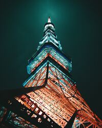
[[File:Maimedo tower at night.jpeg|200px|thumb|left|Maimedo Tower constructed in the 1970s, originally widely criticised as a hideosity in Maimedo's skies has since become an accepted icon of the city]] | |||
WIP | |||
WIP | |||
===Green spaces=== | |||
[[File:Edo Castle (江戸城) East Garden 2 by Don Ramey Logan.jpg|200px|thumb|Seian Park, Silent Gardens Park is the largest park in Esonice.]] | |||
WIP | |||
WIP | |||
==Transport== | ==Transport== | ||
===Trams=== | ===Trams=== | ||
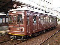
[[File:KeifukuMobo27.JPG|200px|thumb|---]] | |||
WIP | |||
WIP | |||
==Economy== | ==Economy== | ||
===Finance=== | |||
[[File:Tokyo Station at night, Chiyoda, Tokyo; April 2021 (01).jpg|200px|thumb|Taito is the financial district of Maimedo.]] | |||
WIP | |||
WIP | |||
===Tourism=== | |||
==Education== | ==Education== | ||
WIP | |||
==Culture== | ==Culture== | ||
===Art and galleries=== | |||
===Liturature=== | |||
====Local folklore==== | |||
===Local festivals=== | ===Local festivals=== | ||
=== | ===Cuisine=== | ||
=== | ===Sport=== | ||
==Demographics== | |||
===Religion=== | |||
Maimedo has 21 Buddhist temples and 127 Shinshi shrines | |||
== | ===Minority communities=== | ||
==International relations== | ==International relations== | ||
WIP | |||
===Twin towns - sister cities - partnerships=== | ===Twin towns - sister cities - partnerships=== | ||
WIP | |||
{{Div col|colwidth=10em}} | |||
* [[Victoires]], [[Advocatius]] | |||
* [[Penzance]], [[Gaellicia]] | |||
* [[O'polis]], [[Orioni]] | |||
* [[Parsa]], [[Garindina]] | |||
* [[Kauhime|Kauhime]], [[Mito]] | |||
* [[Pavat|Pavat]], [[Cashar]] | |||
* [[Porto Altaria]], [[Iverica]] | |||
* [[Læniguëuíl|Laenigueuil]], [[Gotneska]] | |||
{{Div col end}} | |||
==See also== | ==See also== | ||
Latest revision as of 23:45, 15 October 2023
This article is incomplete because it is pending further input from participants, or it is a work-in-progress by one author. Please comment on this article's talk page to share your input, comments and questions. Note: To contribute to this article, you may need to seek help from the author(s) of this page. |
Maimedo
柑水 | |
|---|---|
| City of Maimedo | |
 Clockwise from top:
| |
| Nickname(s): Maikyo, Maishi, Citrus City, Orange City | |
| Country | |
| Province | Kinkai-koku |
| Local | wards of Maimedo |
| Government | |
| • Body | City Government of Maimedo |
| Area | |
| • Capital | 736.4 km2 km2 (284.32 sq mi) |
| Population (2022) | |
| • Capital | 992,351 |
| • Rank | 1st in Esonice |
| • Density | 1,300/km2 (3,500/sq mi) |
| • Metro | 3,129,121 |
| • Total | 4,121,472 |
| Demonym | Maimedoite |
| Time zone | UTC-8 |
| Post Code | ES-132 |
| Flower | Silky wisteria |
| Food | Sushi donut |
| Tree | Bellflower cherry |
Maimedo (maɪmɛdəʊ; Esonian: 柑水, maimɛdɔ), also semi-officially known as Maikyo (maɪkiəʊ; Esonian: 柑京, maikʲoː), officially the Capital City of Maimedo is the national capital and largest city in Esonice with an estimated population of 992,351. The metropolitan area which includes an estimated population of 3,129,121 brings the greater city’s metropolitan population to 4,121,472 inhabitants. For nearly a millennia since the 12th century, Maimedo was and continues to be Esonice’s beating political and cultural heart. It’s a centre of traditional and modern Esonian fashion, cuisine, literature and art. It’s also an important centre of finance and commerce in the nation. Because of its many orange terracotta and clay tile ladenned roofs including copper coloured limestone buildings, Maimedo became known in Esonian poetic literature as the “Orange City”, hence its nickname.
Maimedo is tied with Marusonya on the highest standard of living in Esonice, however it's beaten by Marusonya in quality of life, coming in second though still closely behind.
Etymology
WIP
History
Origins
12th and 19th centuries
Decay and destruction
Contemporary period
Geography
WIP
Government
WIP
Wards
Nakagusa is the administrative centre of Maimedo.
| name | Full name | Population | ||
|---|---|---|---|---|
| Esonian | Transcription | Translation | ||
| Nakagusa | 中草区 | Nakagusa-vu | Nakagusa Ward | 101,792 |
| Ōzō | 旺蔵区 | Ōzō-vu | Ōzō Ward | 83,399 |
| Seian | 静苑区 | Seian-vu | Seian Ward | 103,426 |
| Kābashi | 幸橋区 | Kābashi-vu | Kābashi Ward | 94,623 |
| Momosaka | 桃坂区 | Momosaka-vu | Momosaka Ward | 81,364 |
| Saito | 西門区 | Saito-vu | Saito Ward | 112,598 |
| Aumata | 青復区 | Aumata-vu | Aumata Ward | 52,975 |
| Sasabo | 笹保区 | Sasabo-vu | Sasabo Ward | 78,191 |
| Tanto | 東門区 | Tanto-vu | Tanto Ward | 136,577 |
| Nara | 楢区 | Nara-vu | Nara Ward | 57,728 |
| Kehara | 毛原区 | Kehara-vu | Kehara Ward | 89,678 |
Cityscape
Urbanism and architecture
WIP
WIP
Green spaces
WIP
WIP
Transport
Trams
WIP
WIP
Economy
Finance
WIP
WIP
Tourism
Education
WIP
Culture
Art and galleries
Liturature
Local folklore
Local festivals
Cuisine
Sport
Demographics
Religion
Maimedo has 21 Buddhist temples and 127 Shinshi shrines
Minority communities
International relations
WIP
Twin towns - sister cities - partnerships
WIP


