Aurelia: Difference between revisions
Jump to navigation
Jump to search
TheRandomHat (talk | contribs) m (→List of States) |
|||
| Line 174: | Line 174: | ||
| Sefesia | | Sefesia | ||
|- | |- | ||
| | | {{flag|United Republic of Aurelia|United Republic}} | ||
| URA | | URA | ||
| style="text-align:right;" | 347,450 | | style="text-align:right;" | 347,450 | ||
Revision as of 14:17, 14 September 2023
 | |
| Area | 13,500,000 km2 (5,200,000 sq mi) |
|---|---|
| Demonym | Aurelian |
| Countries | List of countries in Aurelia |
| Languages | List of languages |
| Time zones | UTC-8 to UTC-4 |
| Largest cities | Yulaa, Bílehora, Port-Réel, Wanaveraʻa, Miyako |
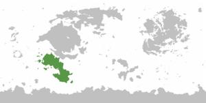
Aurelia is a continent of Eurth, situated south of the continent of Alharu with which it shares a land border, east of Thalassa west of Marenesia and north of Antargis. The Aurelian League is the predominant organization tying the major nation-states of the continent together on matters of defence, economic cooperation, environmental protection, and cultural exchange.
Etymology
History
Ancient Era
- 700 BCE: Rise of Tengrol Empire.
- 218 CE: Fall of Tengrol Empire. Disease from Aroman settlers?
- 300 CE: Aroman settlers come in.
Imperial Era
- 700: Xiseka takes northern Aurelia colonies.
- 1000: Aurelia retakes north.
- 1300-1500: Aurelia decentralises.
- 1515-1535: Mito comes in to take Auriel.
- Xio Kingdom plays off Mito and Auriel and gains independence.
Colonial Era
- Early 1500s: Lysian colonies in southern Aurelia.
- 1525: Aurelian empire formally falls.
- Mid 1550s: Mantellan colonies in southern Aurelia.
- 1580: Taurapetra breaks from Mito. Age of empire on the mainland falls.
- 1594: Dolchland and Rhodellia appear in the Auriel and mainland. Settle in fallen Aurelian provinces.
Early Modern Era
- 1640s onwards: Rhodellia begins to grow. Age of Empire comes to an end.
- 1734: Empire of Great Xio centralised.
- Late 1700s: Anglian colonies in Shfakien region.
- 1800s: First Aurelian War (Napoleonic Kirvina?).
Contemporary Era
- 1926-2000: Flaxzar war.
- 1930s: Second Aurelian War (Mito is a meanie).
- 1938: Formation of the Aurelian League. Direct response to 2nd Aurelian War. Originally a peace organisation.
Geography
- Aurelian Wastes (western Aurelian desert & steppe).
- North Aurelian Plain (large highland region between Wananga and Sfakien mountains).
- Shfakien River Valleys
- Aurelian Shield (island chains across western Aurelia).
- Auriel (southern Aurelia).
Politics
List of States
The list below includes all states under any of the various common definitions of Aurelia, geographic or political.
| Name | ISO 3 Letter Code | Area (km2) |
Population |
Capital | Name(s) in official language(s) |
|---|---|---|---|---|---|
| ADV | 262,174 | 37,421,360 | Victoires | Avouélos | |
| ANA | 235,122 | 34,230,970 | Solisea | Anatea | |
| COT | 302,665 | 6,000,000 | Port au Sud | Qorar | |
| XIO | 793,812 | 8,829,200 | Pashae | Xiohane | |
| ION | 265,644 | 26,768,932 | San Foca | Ionio | |
| KAS | 2,020 | 232,054 | Kaseka | Kaseka | |
| KIR | 558,218 | 37,030,000 | Akhileia | Kirvínastíria | |
| KOL | 245,858 | 39,534,000 | Vakor | Qorar | |
| LRM | 341,869 | 361,225 | Manaca City | Manamaná | |
| Native Aurelian Free State | NAS | 237,682 | 10,000,000 | Klingenfelder | Unknown |
| Proncawi'chi | PRO | 321,300 | 38,000,000 | Unknown | Proncawi'chi |
| RHO | 239,341 | 10,000,000 | Friedrichstadt | Rödelia | |
| SEF | 227,600 | 28,000,000 | Tartessus | Sefesia | |
| URA | 347,450 | 27,000,000 | Grant D.C | United Republic of Aurelia |
Cultures
References
