Lotus Sea: Difference between revisions
No edit summary |
No edit summary |
||
| Line 2: | Line 2: | ||
| name = Lotus Sea | | name = Lotus Sea | ||
| image = Lotus_sea.png | | image = Lotus_sea.png | ||
| other_name = | | other_name = Mar de loto<br>Mer de Lotus | ||
| caption = Lotus Sea | | caption = Lotus Sea | ||
| image_bathymetry = Lotus_Barty_resized.png | | image_bathymetry = Lotus_Barty_resized.png | ||
| Line 20: | Line 18: | ||
| volume = later | | volume = later | ||
}} | }} | ||
The sea | The Lotus Sea is a sea on [[Eurth]] connected to the [[Eurth#Oceans|Oriental Ocean]], surrounded by the [[Aurelia|Aurelian Shield]], [[Alharu|Cashari Island]], Hei Sea, [[Alharu|South-Western Alharan Coast]] and the [[Aurelia|Northern Aurelian Coast]]. The Lotus Sea covers an area of about X,XXX,XXX km2 (XXX,XXX sq mi), representing x% of the glubal ocean surface. The Lotus Sea encompasses a vast number of islands, some of them of volcanic origin. The Lotus Sea has an average depth of 2,950 m (9,678 ft) and the deepest recorded point is 5,102 m (16,738 ft) in the XXX, between [[Giokto]] and [[Goankok]]. | ||
The countries surrounding the Lotus and it's marginal seas in clockwise order are Florentia, Ocraly, Ymutz-Mizlan, Pecario, Manamana, Bushland, Kolhar, Mikochi, Goankok, Giokto and Esonice. In addition, the Maimi territory of Seylos and | The sea was an important route for merchants and travellers of ancient times, facilitating the trade and cultural exchange between the peoples of the region. The [[Sheng dynasty|Sheng Dynasty]] maintained hegemony over the sea for several centuries between . | ||
The countries surrounding the Lotus and it's marginal seas in clockwise order are [[Florentia]], Ocraly, [[Ymutztlaclan-Mizlanuzco|Ymutz-Mizlan]], [[Pecario]], [[Manamana]], Bushland, [[Kolhar]], [[Mikochi]], [[Goankok]], [[Giokto]] and [[Esonice]]. In addition, the [[Maimi]] territory of [[Seylos]] and [[Aurora|Isla de Rosario]] of [[Aurora]] also has a coastline on the Lotus Sea. The drainage basin of the Lotus Sea also extends into [[Great Xio]]. | |||
== Names and etymology == | == Names and etymology == | ||
| Line 34: | Line 33: | ||
'''Mikochinese''' | '''Mikochinese''' | ||
s'''Esonian''' | |||
s | |||
=== Huang === | === Huang === | ||
s | |||
=== Lysian === | === Lysian === | ||
| Line 61: | Line 62: | ||
'''Bahia Del Trebol''' | '''Bahia Del Trebol''' | ||
Bahia Del Trebol'''Manamana Bay''' | |||
Manamana bay | |||
=== Extent === | === Extent === | ||
| Line 72: | Line 74: | ||
=== Other Features === | === Other Features === | ||
=== | === Islands === | ||
A list of important islands in the Lotus Sea. | |||
{| class="wikitable sortable" | |||
|+Islands >= 1,000 km2 (780 sq mi) | |||
!Island | |||
!Area (km2) | |||
!Area (sq mi) | |||
!Population | |||
!Country | |||
|- | |||
|''Cashari Island*'' | |||
| | |||
| | |||
| | |||
|''Florentia, Aurora'' | |||
|- | |||
|Shimdō | |||
| | |||
| | |||
| | |||
|Esonice** | |||
|- | |||
|1 Below Eso | |||
| | |||
| | |||
| | |||
|Esonice | |||
|- | |||
|2 Below Eso | |||
| | |||
| | |||
| | |||
|Esonice | |||
|- | |||
|1 East Eso | |||
| | |||
| | |||
| | |||
| | |||
|- | |||
|2 East Eso | |||
| | |||
| | |||
| | |||
| | |||
|- | |||
|3 East Eso | |||
| | |||
| | |||
| | |||
| | |||
|- | |||
|4 East Eso | |||
| | |||
| | |||
| | |||
| | |||
|- | |||
|Hangoku | |||
| | |||
| | |||
| | |||
|Mikochi | |||
|- | |||
|Seinan | |||
| | |||
| | |||
| | |||
|Mikochi | |||
|- | |||
|1 Shield | |||
| | |||
| | |||
| | |||
| | |||
|- | |||
|2 Shield | |||
| | |||
| | |||
| | |||
| | |||
|- | |||
|Takarajima | |||
| | |||
| | |||
| | |||
|Mikochi | |||
|- | |||
|Kaiyushima | |||
| | |||
| | |||
| | |||
|Mikochi | |||
|- | |||
|Nijinoshima | |||
| | |||
| | |||
| | |||
|Mikochi | |||
|- | |||
|Mishima | |||
| | |||
| | |||
| | |||
|Mikochi | |||
|- | |||
|Aozorashima | |||
| | |||
| | |||
| | |||
|Mikochi | |||
|- | |||
|Giokto | |||
| | |||
| | |||
| | |||
|Giokto | |||
|- | |||
|Goankok Major | |||
| | |||
| | |||
| | |||
|Goankok | |||
|- | |||
|Goankok Minor | |||
| | |||
| | |||
| | |||
|Goa | |||
|- | |||
|Kolhar Major | |||
| | |||
| | |||
| | |||
|Kolhar | |||
|- | |||
|Kolhar Minor | |||
| | |||
| | |||
| | |||
|Kolhar | |||
|- | |||
|Satanaza | |||
| | |||
| | |||
| | |||
| | |||
|- | |||
|Isla de Rosario | |||
| | |||
| | |||
| | |||
|Aurelia | |||
|- | |||
|1 East Kolhar | |||
| | |||
| | |||
| | |||
| | |||
|- | |||
|Bushland Major | |||
| | |||
| | |||
| | |||
|Bushland | |||
|- | |||
|Bushland Minor | |||
| | |||
| | |||
| | |||
|Bushland | |||
|} | |||
<nowiki>*</nowiki>Although Cashari Island extends into the Lotus Sea, it was exluded from the study as it is classified as a subcontinent of Alharu. | |||
<nowiki>**</nowiki>Shimdō is also partially controlled by Seylos, Florentia, Motoharu and Yedo. | |||
=== Climate === | === Climate === | ||
== Biodiversity == | == Biodiversity == | ||
sharks | |||
=== Vegetation & Coral === | |||
[underwater plants, coastal plants, plants only in this area/predominantly, corals] | |||
=== Fauna === | |||
[sharks,fish, birds...] | |||
== Gallery == | == Gallery == | ||
<gallery> | <gallery> | ||
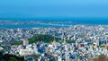
File:KagayakiCity1.jpg|Kagayaki City | File:KagayakiCity1.jpg|Kagayaki City in Mikochi, with the Lotus Sea in the background. | ||
</gallery> | </gallery> | ||
{{Eurth}} | {{Eurth}} | ||
Revision as of 12:48, 17 September 2024
| Lotus Sea | |
|---|---|
| Mar de loto Mer de Lotus | |
 Lotus Sea | |
 Bathymetry of the Lotus Sea | |
| Location | North-Western Aurelia
South-Western Alharu Eastern Thalassa |
| Coordinates | 0° 105°W |
| Type | Sea |
| Etymology | Lotus Flower |
| Average depth | 2,950 metres (9,678.478 ft) |
| Max. depth | 5,102 metres (16,738.85 ft) |
| Water volume | later |
| Shore length1 | later |
| Islands | Atleast 6 |
| 1 Shore length is not a well-defined measure. | |
The Lotus Sea is a sea on Eurth connected to the Oriental Ocean, surrounded by the Aurelian Shield, Cashari Island, Hei Sea, South-Western Alharan Coast and the Northern Aurelian Coast. The Lotus Sea covers an area of about X,XXX,XXX km2 (XXX,XXX sq mi), representing x% of the glubal ocean surface. The Lotus Sea encompasses a vast number of islands, some of them of volcanic origin. The Lotus Sea has an average depth of 2,950 m (9,678 ft) and the deepest recorded point is 5,102 m (16,738 ft) in the XXX, between Giokto and Goankok.
The sea was an important route for merchants and travellers of ancient times, facilitating the trade and cultural exchange between the peoples of the region. The Sheng Dynasty maintained hegemony over the sea for several centuries between .
The countries surrounding the Lotus and it's marginal seas in clockwise order are Florentia, Ocraly, Ymutz-Mizlan, Pecario, Manamana, Bushland, Kolhar, Mikochi, Goankok, Giokto and Esonice. In addition, the Maimi territory of Seylos and Isla de Rosario of Aurora also has a coastline on the Lotus Sea. The drainage basin of the Lotus Sea also extends into Great Xio.
Names and etymology
Anglian
Lotus Sea
Azumic
Mikochinese
sEsonian
s
Huang
s
Lysian
Mer de Lotus
Stillian
Mar de loto
History
Proto-Azumic Migrations
They moved from the desert
Sheng Dynasty and Medieval Era
They conquered
Aurelian Wars & Modern Era
They warred
Geography
Marginal Seas
Bahia Del Trebol
Bahia Del TrebolManamana Bay
Manamana bay
Extent
Exclusive Economic Zone
Coastal Cities
Other Features
Islands
A list of important islands in the Lotus Sea.
| Island | Area (km2) | Area (sq mi) | Population | Country |
|---|---|---|---|---|
| Cashari Island* | Florentia, Aurora | |||
| Shimdō | Esonice** | |||
| 1 Below Eso | Esonice | |||
| 2 Below Eso | Esonice | |||
| 1 East Eso | ||||
| 2 East Eso | ||||
| 3 East Eso | ||||
| 4 East Eso | ||||
| Hangoku | Mikochi | |||
| Seinan | Mikochi | |||
| 1 Shield | ||||
| 2 Shield | ||||
| Takarajima | Mikochi | |||
| Kaiyushima | Mikochi | |||
| Nijinoshima | Mikochi | |||
| Mishima | Mikochi | |||
| Aozorashima | Mikochi | |||
| Giokto | Giokto | |||
| Goankok Major | Goankok | |||
| Goankok Minor | Goa | |||
| Kolhar Major | Kolhar | |||
| Kolhar Minor | Kolhar | |||
| Satanaza | ||||
| Isla de Rosario | Aurelia | |||
| 1 East Kolhar | ||||
| Bushland Major | Bushland | |||
| Bushland Minor | Bushland |
*Although Cashari Island extends into the Lotus Sea, it was exluded from the study as it is classified as a subcontinent of Alharu.
**Shimdō is also partially controlled by Seylos, Florentia, Motoharu and Yedo.
Climate
Biodiversity
Vegetation & Coral
[underwater plants, coastal plants, plants only in this area/predominantly, corals]
Fauna
[sharks,fish, birds...]
Gallery
Kagayaki City in Mikochi, with the Lotus Sea in the background.
