Lotus Sea: Difference between revisions
mNo edit summary |
mNo edit summary |
||
| Line 33: | Line 33: | ||
'''Esonian''' | '''Esonian''' | ||
In the Esonian language, the Lotus Sea is known as ''Ryankai'' (蓮海 | In the Esonian language, the Lotus Sea is known as ''Ryankai'' (蓮海, literally 'Lotus Sea'). The name ''Ryankai'', Lotus Sea in Esonice has been in use for several centuries, first being mentioned in texts of the emergent Serene Kingdom in the late 10th century. It is believed that the name 'Lotus Sea' entered the Anglish language through Esonian to refer to the sea. | ||
'''Mitonese''' | '''Mitonese''' | ||
Latest revision as of 13:25, 18 September 2024
| Lotus Sea | |
|---|---|
| Mar de loto Mer de Lotus | |
 Lotus Sea | |
 Bathymetry of the Lotus Sea | |
| Location | North-Western Aurelia
South-Western Alharu Eastern Thalassa |
| Coordinates | 0° 105°W |
| Type | Sea |
| Etymology | Nelumbo nucifera, lotus |
| Average depth | 2,950 metres (9,678.478 ft) |
| Max. depth | 5,102 metres (16,738.85 ft) |
| Water volume | later |
| Shore length1 | later |
| Islands | Atleast 6 |
| 1 Shore length is not a well-defined measure. | |
The Lotus Sea is a sea on Eurth connected to the Oriental Ocean, surrounded by the Aurelian Shield, Cashari Island, Hei Sea, South-Western Alharan Coast and the Northern Aurelian Coast. The Lotus Sea covers an area of about X,XXX,XXX km2 (XXX,XXX sq mi), representing x% of the glubal ocean surface. The Lotus Sea encompasses a vast number of islands, some of them of volcanic origin. The Lotus Sea has an average depth of 2,950 m (9,678 ft) and the deepest recorded point is 5,102 m (16,738 ft) in the XXX, between Giokto and Goankok.
The sea was an important route for merchants and travellers of ancient times, facilitating the trade and cultural exchange between the peoples of the region. The Sheng Dynasty maintained hegemony over the sea for several centuries between .
The countries surrounding the Lotus and it's marginal seas in clockwise order are Florentia, Ocraly, Ymutz-Mizlan, Pecario, Manamana, Bushland, Kolhar, Mikochi, Goankok, Giokto and Esonice. In addition, the Maimi territory of Seylos, the Yedo territory of Garindina, and Isla de Rosario of Aurora also has a coastline on the Lotus Sea. The drainage basin of the Lotus Sea also extends into Great Xio.
Names and etymology
Anglian
The Anglish name for the sea is speculated to originate from Esonian sources through trade.
Azumic Languages
Esonian
In the Esonian language, the Lotus Sea is known as Ryankai (蓮海, literally 'Lotus Sea'). The name Ryankai, Lotus Sea in Esonice has been in use for several centuries, first being mentioned in texts of the emergent Serene Kingdom in the late 10th century. It is believed that the name 'Lotus Sea' entered the Anglish language through Esonian to refer to the sea.
Mitonese
The official name for the sea in Mitonese and most Azumic is Hasu-kai (蓮の海), or sometimes Rōtasu shī (ロータス・シー)
Mikochinese
In Mikochinese, the name for the Lotus Sea has changed several times, however is currently named Hasu-kai (蓮の海). In early Mikochinese literature, the sea was referred to as Chuo-kai (中海), taking influence from Sheng geographers. The name stuck until 16XX, when Hakkei Yuji reunified Mikochi. He declared the name of the sea to become Miko-kai (海越の海), literally translating to Sea of Mikochi, as part of the greater Hakkei goal to assert dominance in the Lotus Sea.
Huang
During the Sheng era, the Lotus Sea was referred to as Tionghái (中海), literally meaning Middle Sea.
Lanang
In Lanang, like Huang during the Sheng era, the Lotus Sea was referred to as the 'Middle Sea', in Lanang Tiong-hái. In later centuries however, Lanang speakers also made the switch to the name 'Lotus Sea', in Lanang Liân-hái.
Lysian
Mer de Lotus (WIP)
Stillian
Mar de Loto (WIP)
History
Proto-Azumic Migrations
They moved from the desert (WIP)
Sheng Dynasty and Medieval Era
They conquered (WIP)
Aurelian Wars & Modern Era
They warred (WIP)
Geography
Marginal Seas
Bahia Del Trebol
Bahia Del Trebol (WIP)
Manamana Bay
Manamana bay (WIP)
Chidama Sea
The Chidama Sea, in Esonian Chidama-kai (千珠海, 'Sea of a Thousand Pearls') is located between Esonice and the Eastern Islands, also known as the Sanshu Islands (三州島々, literally 'Three Province Islands'). The sea historically played and continues to play a important role in the economy of Esonice and the Sanshu Islands from trade to fishing, the sea being an outlet to Nagihaya Bay in which Esonice's historic economic heart lays, the city of Maruguchi. The sea got its name due to its role in pearl-harvesting, hence it being called 'The Thousand Pearl Sea' in Esonian.
Extent
(WIP)
Exclusive Economic Zone
(WIP)
Major Cities
| City | Population | Country |
|---|---|---|
| Umikyo | Mikochi | |
| Akahama | Mikochi | |
| Kagayaki | Mikochi | |
| Sakurazaki | Mikochi | |
| Kinko | Mikochi | |
| Sisimto | Goankok | |
| Sushu | 1,646,473 | Esonice |
| Maruguchi | 2,285,038 | Esonice |
| Maimedo | 4,121,472 | Esonice |
| Okado | 1,902,872 | Esonice |
| Maimi | 326,524 | Seylos |
| Ryuguchi | 1,084,667 | Esonice |
| Yedo | 215,130 | Garindina |
| Motoharu-chu | Motoharu | |
| Belleville | Florentia | |
| Mouvant | Florentia | |
| Teldore | Florentia | |
| Sademi | Sademi-Mihura | |
| Solmarina | Pecario | |
| San Cristobal | Manamana | |
| Coltington | Bushland |
Other Features
(WIP)
Islands
A list of important islands in the Lotus Sea.
| Island | Area (km2) | Area (sq mi) | Population | Country |
|---|---|---|---|---|
| Cashari Island* | Florentia, Aurora | |||
| Shimdo | Esonice** | |||
| Ajima | Esonice | |||
| Hushima | Esonice | |||
| Nisushima | ||||
| Kunzan | ||||
| Tyudo | ||||
| Kimtsu | ||||
| Hangoku | Mikochi | |||
| Seinan | Mikochi | |||
| 1 Shield | ||||
| 2 Shield | ||||
| Takarajima | Mikochi | |||
| Kaiyushima | Mikochi | |||
| Nijinoshima | Mikochi | |||
| Mishima | Mikochi | |||
| Aozorashima | Mikochi | |||
| Giokto | Giokto | |||
| Goankok Major | Goankok | |||
| Luminara | Goankok | |||
| Kolhar Major | Kolhar | |||
| Kolhar Minor | Kolhar | |||
| Satanaza | ||||
| Isla de Rosario | Aurelia | |||
| 1 East Kolhar | ||||
| Bushland Major | Bushland | |||
| Bushland Minor | Bushland |
*Although Cashari Island extends into the Lotus Sea, it was exluded from the study as it is classified as a subcontinent of Alharu.
**While most of Shimdo is part of Esonice, Seylos, Florentia and Garindina possess coastal territories on the island. Esonice also shares the island with the independent citystate of Motoharu.
Climate
Biodiversity
Vegetation & Coral
[underwater plants, coastal plants, plants only in this area/predominantly, corals]
Fauna
[sharks,fish, birds...]
Gallery
Kagayaki City in Mikochi, with the Lotus Sea in the background.

Maimi, Autonomous Territory of Seylos on Shimdo.

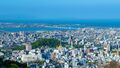
Maruguchi, the second largest city of Esonice

Sushu, capital of Nanzan Province in Esonice


