Geography of Roqoo
Jump to navigation
Jump to search
| Continent | Alharu |
|---|---|
| Region | North-central Alharu |
| Area | |
| • Total | 325,020 km2 (125,490 sq mi) |
| • Land | 97%% |
| • Water | Expression error: Unrecognized punctuation character "%".% |
| Coastline | 127 km (79 mi) |
| Highest point | Korkein Point, Eastern Highlands 1,119 m |
| Lowest point | Asmaru Bay 0 m |
| Longest river | Suuri |
| Largest lake | Maamme sisameri |
| Climate | Varied; Warm continental and Oceanic climate throughout |
| Terrain | mainly flat, narrow valley in north extending to broad low valley in south. Bordered by "highlands" on east and west. |
| Natural Resources | Various marine life and mineral resources in territorial waters, large deposits of iron ore, rare metals, natural gas, minerals, and timber stills on land. |
| Natural Hazards | eurthquakes, landslides, and sandstorms particularly in southern Roqoo |
| Environmental Issues | deforestation; overfishing; desertification; endangered wildlife |
Roqoo is a country in North-Central Alharu stretching along the low Avaara valley of the Suuri river, which connects Chenshas Lake, an inland sea and largest freshwater lake on Eurth, in the south, to Asmaru Bay on the Ygros Sea in the north. Roqoo is bordered by Alharic highlands to the east and west. At 325,620 km2 (125,700 sq mi), Roqoo is the seventh largest nation in Alharu. Roqoo has a short 127 km coastline in the north and a 426 km shoreline on theAitivedet arm (lit: "mother waters) of Chenshas Lake in the south. It claims a small Exclusive Economic Zone of 40,386 km2 (15,593 sq mi).
Terrain
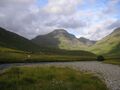
Korkein Point, the highest point in the nation at 1,119 m (3,671 ft).
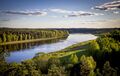
The Suuri river in south-central Roqoo.


Natural Resources
Environment
Climate
Coastal
| Læniguëuíl | ||||||||||||||||||||||||||||||||||||||||||||||||||||||||||||
|---|---|---|---|---|---|---|---|---|---|---|---|---|---|---|---|---|---|---|---|---|---|---|---|---|---|---|---|---|---|---|---|---|---|---|---|---|---|---|---|---|---|---|---|---|---|---|---|---|---|---|---|---|---|---|---|---|---|---|---|---|
| Climate chart (explanation) | ||||||||||||||||||||||||||||||||||||||||||||||||||||||||||||
| ||||||||||||||||||||||||||||||||||||||||||||||||||||||||||||
| ||||||||||||||||||||||||||||||||||||||||||||||||||||||||||||
Highlands
| History | |||||||||
|---|---|---|---|---|---|---|---|---|---|
| Continents & 133 Countries | |||||||||
| Geography |
| ||||||||
| Organisations |
| ||||||||
| Politics | |||||||||
| Law | |||||||||
| Military | |||||||||
| Economics | |||||||||
| Culture | |||||||||
| Sports | |||||||||