UBPSSIF Protected Marine Reserve: Difference between revisions
mNo edit summary |
m (→References: +Category:Thalassa) |
||
| (7 intermediate revisions by the same user not shown) | |||
| Line 3: | Line 3: | ||
| iucn_category = Ia | | iucn_category = Ia | ||
| photo = Bunaken Marine Park.JPG | | photo = Bunaken Marine Park.JPG | ||
| photo_alt = | | photo_alt = UBPSSIF Protected Marine Reserve | ||
| photo_caption = | | photo_caption = | ||
| location = [[Thalassa]], [[Eurth]] | | location = [[Thalassa]], [[Eurth]] | ||
| nearest_city = [[Burkini#Geography|Cronulla]], [[Burkini]] | | nearest_city = [[Burkini#Geography|Cronulla]], [[Burkini]] | ||
| coordinates=<!-- for documentation page only - not general practice --> | | coordinates = <!-- for documentation page only - not general practice --> | ||
| scale = | | scale = | ||
| | | area_km2 = 4,805,167.171 | ||
| established = {{start date|2017| | | established = {{start date|2017|03|19}}<ref>[https://www.europans.com/topic/4305-map-v4-applications-releases/?do=findComment&comment=40012869 Map of Eurth] (19 March 2017)</ref> | ||
| visitation_num = | | visitation_num = 17 | ||
| visitation_year = | | visitation_year = 2020 | ||
| governing_body = | | governing_body = [[Civil Administration of Oriental States]] | ||
| world_heritage_site = | | world_heritage_site = | ||
| url = | | url = | ||
}} | }} | ||
The '''UBPSSIF Protected Marine Reserve''' is a {{wp|marine protected area}} in the [[Oriental Ocean]] of North [[Thalassa]]. A {{wp|marine reserve}} provides | The '''UBPSSIF Protected Marine Reserve''' is a {{wp|marine protected area}} in the [[Oriental Ocean]] of North [[Thalassa]]. The northern edge is marked by the Dobbarrier Reef.<ref>[https://www.europans.com/topic/4305-map-v4-applications-releases/?do=findComment&comment=40013197 Map of Eurth] (26 April 2019)</ref> A {{wp|marine reserve}} provides “maximum protection” for all biodiversity. Resource removals and all but light human removals are strictly prohibited. | ||
The area is home to dense native ecosystems where only scientific study, environmental monitoring and education are allowed. The UBPSSIF is a favourite migration route of many whale species. Most whales prefer the colder waters of the northern and southern hemispheres, and migrate to the equator to give birth. The long north-south layout allows whales to migrate undisturbed from the colder North Pole region to the tropical archipelago of [[Sunset Sea Islands]]. | The area is home to dense native ecosystems where only scientific study, environmental monitoring and education are allowed. The UBPSSIF is a favourite migration route of many whale species. Most whales prefer the colder waters of the northern and southern hemispheres, and migrate to the equator to give birth. The long north-south layout allows whales to migrate undisturbed from the colder North Pole region to the tropical archipelago of [[Sunset Sea Islands]]. | ||
| Line 27: | Line 27: | ||
Rotjan - Enderbury Day 1 - 2nd half (62).JPG|Coral reefs near the southern edge of the reserve. | Rotjan - Enderbury Day 1 - 2nd half (62).JPG|Coral reefs near the southern edge of the reserve. | ||
Great Barrier Reef (aerial view).JPG|The Dobbarrier Reef is clearly visible from an aircraft. | Great Barrier Reef (aerial view).JPG|The Dobbarrier Reef is clearly visible from an aircraft. | ||
Acropora latistella (Table coral).jpg|Table coral ''{{wp|Acropora|Acropora latistella}}''. | |||
Pink soft coral Nick Hobgood.jpg|Pink soft coral. | |||
Nembrotha kubaryana.jpg|''{{wp|Nembrotha kubaryana}}''. | |||
Christmas tree worms.jpg|{{wp|Christmas tree worm}}s (''Spirobranchus giganteus''). | |||
Parrotfish turquoisse.jpg|{{wp|Parrotfish}}. | |||
Solenostomus paradoxus (Harlequin ghost pipefish).jpg|{{wp|Solenostomus paradoxus|Harlequin ghost pipefish}}. | |||
Anemone purple anemonefish.jpg|{{wp|Anemonefish}} (''Amphiprion ocellaris''). | |||
White eyed moray eel.jpg|White-eyed moray eel (''Gymnothorax thyrsoideus''). | |||
Lakshadweep - Agatti Islands.jpg|Beautiful turquoise waters, white sands and waving coconut trees on {{wp|Agatti Island|Itagi Island}}. | |||
</gallery> | </gallery> | ||
== Controversy == | |||
According to leaked [[Black Hat]] documents, in a calculated move planned in 2017, the [[Sunset Sea Islands]] proposed that the UBPSSIF become a “marine reserve” with the aim of preventing the former inhabitants from returning to the islands.<ref>Wikileaks, [https://wikileaks.org/plusd/cables/09LONDON1156_a.html HMG floats proposal for marine reserve covering the Chagos archipelago] (15 May 2009)</ref> A summary of the leaked cable mentions how: | |||
<blockquote>The government wants to establish a closed “marine nature park” to provide broad environmental protection to the reefs and waters of the UBPSSIF. The secondary objective of establishing this enormous marine park to prevent the former inhabitants from returning to or pursuing their claim for resettlement in the area. Careful negotiation was advised to achieve the tertiary objective: safeguarding SSI interests and the strategic value of the UBPSSIF, including military purposes.</blockquote> | |||
The leaked document shows that this plan was dreamt up by government officials to preserve the area as a military outpost, and prevent the native people from returning. In response, multiple MPs from the [[Sunset Sea Islands|SSI]] spoke out and claimed they were tricked into supporting the creation of this marine reserve. | |||
== References == | |||
{{Reflist}} | |||
{{Eurth}} | {{Eurth}} | ||
[[Category:Thalassa]] | |||
Latest revision as of 17:18, 11 December 2023
| UBPSSIF Protected Marine Reserve | |
|---|---|
IUCN category Ia (strict nature reserve) | |
 | |
| Location | Thalassa, Eurth |
| Nearest city | Cronulla, Burkini |
| Area | 4,805,167.171 km2 (1,855,285.417 sq mi) |
| Established | March 19, 2017[1] |
| Visitors | 17 (in 2020) |
| Governing body | Civil Administration of Oriental States |
The UBPSSIF Protected Marine Reserve is a marine protected area in the Oriental Ocean of North Thalassa. The northern edge is marked by the Dobbarrier Reef.[2] A marine reserve provides “maximum protection” for all biodiversity. Resource removals and all but light human removals are strictly prohibited.
The area is home to dense native ecosystems where only scientific study, environmental monitoring and education are allowed. The UBPSSIF is a favourite migration route of many whale species. Most whales prefer the colder waters of the northern and southern hemispheres, and migrate to the equator to give birth. The long north-south layout allows whales to migrate undisturbed from the colder North Pole region to the tropical archipelago of Sunset Sea Islands.
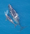
A whale with her calf.
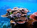
A variety of colourful corals.

Coral reefs near the southern edge of the reserve.

The Dobbarrier Reef is clearly visible from an aircraft.
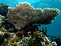
Table coral Acropora latistella.

Pink soft coral.

Christmas tree worms (Spirobranchus giganteus).

Anemonefish (Amphiprion ocellaris).

White-eyed moray eel (Gymnothorax thyrsoideus).

Beautiful turquoise waters, white sands and waving coconut trees on Itagi Island.


.JPG)
.JPG)
.jpg)


.jpg)


Controversy
According to leaked Black Hat documents, in a calculated move planned in 2017, the Sunset Sea Islands proposed that the UBPSSIF become a “marine reserve” with the aim of preventing the former inhabitants from returning to the islands.[3] A summary of the leaked cable mentions how:
The government wants to establish a closed “marine nature park” to provide broad environmental protection to the reefs and waters of the UBPSSIF. The secondary objective of establishing this enormous marine park to prevent the former inhabitants from returning to or pursuing their claim for resettlement in the area. Careful negotiation was advised to achieve the tertiary objective: safeguarding SSI interests and the strategic value of the UBPSSIF, including military purposes.
The leaked document shows that this plan was dreamt up by government officials to preserve the area as a military outpost, and prevent the native people from returning. In response, multiple MPs from the SSI spoke out and claimed they were tricked into supporting the creation of this marine reserve.
References
- ↑ Map of Eurth (19 March 2017)
- ↑ Map of Eurth (26 April 2019)
- ↑ Wikileaks, HMG floats proposal for marine reserve covering the Chagos archipelago (15 May 2009)
| History | |||||||||
|---|---|---|---|---|---|---|---|---|---|
| Continents & 133 Countries | |||||||||
| Geography |
| ||||||||
| Organisations |
| ||||||||
| Politics | |||||||||
| Law | |||||||||
| Military | |||||||||
| Economics | |||||||||
| Culture | |||||||||
| Sports | |||||||||