Hodrea: Difference between revisions
m (→History) |
|||
| Line 56: | Line 56: | ||
==Geography== | ==Geography== | ||
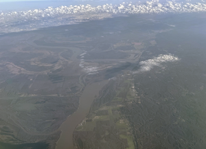
[[File:Hodrea_air.png|left|thumb|The Ket River in the northern part of the country from the air.]] | |||
Hodrea is split between its southern highlands and its northern lowlands. The Innere Mountain Range dominates southern Hodrea, stretching across almost all of its border with the [[Sentist State]]. | Hodrea is split between its southern highlands and its northern lowlands. The Innere Mountain Range dominates southern Hodrea, stretching across almost all of its border with the [[Sentist State]]. | ||
The mountains of Hodrea is where the majority of forested land is still found. Most of the land is unsuitable for buildling, and as a result there are few large population centers. However there are many smaller communities that dot the mountains and highlands with economies built mostly off of natural resource aquisition. In the southwest of the country, is a smaller land area away from the mountains that contains much larger cities as the mountains give away. | The mountains of Hodrea is where the majority of forested land is still found. Most of the land is unsuitable for buildling, and as a result there are few large population centers. However there are many smaller communities that dot the mountains and highlands with economies built mostly off of natural resource aquisition. In the southwest of the country, is a smaller land area away from the mountains that contains much larger cities as the mountains give away. | ||
The Hodrean north is mostly dominated by open fields. Long ago the land was heavily forested, however as human settlement expanded much of the tree cover of the north was stripped away. By 2020 much of those fields, primarily used for agriculture, has suffered significant losses in nutrients as poor land management took its toll. | The Hodrean north is mostly dominated by open fields. Long ago the land was heavily forested, however as human settlement expanded much of the tree cover of the north was stripped away. By 2020 much of those fields, primarily used for agriculture, has suffered significant losses in nutrients as poor land management took its toll. | ||
Revision as of 20:08, 4 September 2022
Hodrean Provisional State Hodrea | |
|---|---|
| Motto: | |
 | |
| Status | Independent State |
| Capital | Liechnenfax |
| Largest city | Halver |
| Official languages | Anglish, Dolch |
| Religion | (No official religion) |
| Demonym(s) | Hodrean |
| Government | Democratic Provisional Government |
• Provisional President | Derren Werner |
| Legislature | Hodrean Provisional Government |
| Establishment | |
• Hodrean Kingdom | 1618 |
| Population | |
• (2022 Estimate) census | 13,456,00 |
| GDP (nominal) | estimate |
• Total | $61.843 Billion |
• Per capita | $4596 |
| HDI (2018) | .68 medium |
| Currency | Seylosian Pound (Temporary) (KSP) |
| Time zone | GMT -0 |
| Driving side | right |
| Calling code | +789 |
| Internet TLD | .hd |
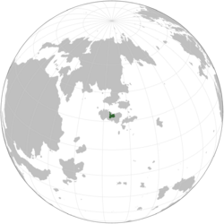
The Hodrean Provisional State, commonly known as Hodrea, is a sovereign state in north central Ceris in Southern Argis.
History
The original settlers of Ceris originaly came from the north across the Dolch Sea from the now Dolchland around 670 CE. These settlers readily populated the western and northern coasts of the island forming several tribal organizations. During this time there were several Geltic tribes in the east of Ceris. The Dolch and Gelts however had only sproadic contact as most Dolch migrations were focused on the mainland of Argis and the Gelt population in the island of Seylos was already so small that little filtered into Ceris.
By the 1600s however the situation in Ceris changed radically as Seylosian settlement was in ernest and Dolch settlers readily made their way into Ceris. Eventually the first major nation that appeared in Ceris would be the Hodrean Kingdom, and it would capitalize on its size by quickly dominating most Ceriser politics. By the mid 1700s, all of Ceris, save several small eastern states close to Seylos, was completely under the control of the Hodrean Kingdom. For almost the next two hundred years the Hodrean Kingdom would exist in a form of middle prosperity when eventually hit a period of decline in the early 1900s. By the 1950s they were in a severely weakened state, with corruption apparent in most levels of government. Eventually the Seylosian Mandate, seeking to dominate the island, began its invasion of the country and fully conquered it. The island was occupied for several years under Mandate rule before the Seylosian Monarchy took control of Seylos again.
After the war, the Hodrean Kingdom was given its former territories back, but lacked any form of real control over them. In 1958, the first in a series of violent civil wars would spread across the island fracturing the Kingdom. By the late 1960s, all that remained of the Kingdom was where modern day Hodrea and Rewhain exist. The last civil war happened in 1963, where the now indpendent Rewhain fought bitterly against the Hodreans for five years until peace was settled. With the failure of another conflict over their heads, the Hodrean monarchy was deposed by an authoritarian strongman, Sebastian Bösch, and sent into exile. Hodrea would maintain its authoritarian government until the beginning of the Sentist War, when most of its leadership fled.
Geography
Hodrea is split between its southern highlands and its northern lowlands. The Innere Mountain Range dominates southern Hodrea, stretching across almost all of its border with the Sentist State.
The mountains of Hodrea is where the majority of forested land is still found. Most of the land is unsuitable for buildling, and as a result there are few large population centers. However there are many smaller communities that dot the mountains and highlands with economies built mostly off of natural resource aquisition. In the southwest of the country, is a smaller land area away from the mountains that contains much larger cities as the mountains give away.
The Hodrean north is mostly dominated by open fields. Long ago the land was heavily forested, however as human settlement expanded much of the tree cover of the north was stripped away. By 2020 much of those fields, primarily used for agriculture, has suffered significant losses in nutrients as poor land management took its toll.
