Geography of Esonice: Difference between revisions
No edit summary |
(reverting vandalism) |
||
| (18 intermediate revisions by 4 users not shown) | |||
| Line 1: | Line 1: | ||
== | {{short description|Geographical features of Esonice}} | ||
{{Infobox country geography | |||
| name = Esonice | |||
| map = | |||
| continent = [[Alharu|Alharu]] | |||
| region = [[Alharu|West Alharu]], [[Thalassa|Eastern Thalassa]] | |||
| coordinates = | |||
| area ranking = | |||
| km area = 354,835 | |||
| percent land = | |||
| km coastline = | |||
|exclusive economic zone = | |||
| geographic center = | |||
| highest point = | |||
| lowest point = | |||
| longest river = | |||
| largest lake = [[Geography of Esonice#Lakes|Lake Gamari]] | |||
| climate = Varied; {{wp|humid subtropical|Wet subtropical}} to the east, transitioning in the west to {{wp|tropical savanna climate|tropical savannah}}, and then {{wp|semi-arid climate|dry semi-arid}} to the north western coasts, with mountainous places being {{wp|Oceanic climate|subtropical oceanic climates}} with rare snow | |||
| terrain = mainly flat with volcanic and mountainous features | |||
| natural resources = Large {{wp|ore|deposits}} of various {{wp|gemstones|gems}}, {{wp|marine life|marine life}} and {{wp|mineral|mineral}} {{wp|resource|resources}} in {{wp|territorial waters|territorial waters}}, deposits of {{wp|iron|iron}}, {{wp|gold|gold}}, {{wp|silver|silver}}, {{wp|zinc|zinc}}, {{wp|copper|copper}} and minerals on {{wp|land|land}}, including {{wp|kaolin|kaolin}}, {{wp|marble|marble}} and {{wp|limestone|limestone}} | |||
| natural hazards = {{wp|volcanic eruption|volcanic eruptions}}, {{wp|sandstorm|sandstorms|}}, {{wp|tsunami|tsunamis}}, {{wp|earthquake|eurthquakes}}, [[Geography of Esonice#psuedo-monsoons|psuedo monsoons]], {{wp|drought|droughts}} | |||
| environmental issues = {{wp|air pollution|air pollution}}; {{wp|deforestation|deforestation}}; {{wp|overfishing|overfishing}}; {{wp|desertification|desertification}}; {{wp|freshwater acidification|acidification}} of lakes and reservoirs; {{wp|endangered species|endangered wildlife}} | |||
}} | |||
[[Esonice|Esonice]] is an {{wp|Island nation|island nation}} situated in the Esonian archipelago, surrounded by the [[Eurth#Oceans|Tiauhai Sea]], which Esonians call 'the Sea of the Moon' (Esonian: Motsu no Koshin) and the [[Eurth#Oceans|Sea of the Rising Sun]] (Esonian: Motsu no ---) in the [[Eurth#Oceans|North Oriental Ocean]], compromising of an {{wp|archipelago|archipelago}} of 4 major {{wp|Island|islands}}, 3 minor islands and --- smaller islands. The major island Esonice occupies is the island of [[Esonian archipelago#Hirosho|Hirosho]], which is the biggest island in the archipelago, and two smaller but noticeable islands in the south that are the islands of [[Esonian archipelago#Mibiveshi|Mibiveshi]] and [[Esonian archipelago#Lisharishi|Lisharishi]]. All together, Esonice holds 254 in its possession; but only 20 of those are inhabited permanently. There are 234 remote islands with no inhabitants, 48 of those were turned into {{wp|nature reserve|protected wildlife reserves}}. | |||
All together, Esonice's territory covers 354,835 km2 (137,003 sq mi), making it the - largest island nation, and the - largest {{wp|nation|nation}} in the wulrd. It is the 2nd largest island nation in both [[Alharu|Alharu]] and [[Thalassa|Thalassa]]. | |||
==Regions & provinces== | |||
Esonice has historically been divided into 8 regions, those regions being: | |||
* Vellisia(Velisya | |||
* Yatoshi | |||
* Dahomi | |||
* Alodia(Alodya) | |||
* Juraba | |||
* Chiyashi | |||
* Kumiko | |||
* --- | |||
==Topography, geology and geographical features== | ==Topography, geology and geographical features== | ||
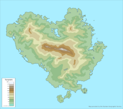
[[File:Topographic map of Esonice.png|250px|thumb|{{wp|Topography|Topgraphic map}} of Esonice]] | |||
===Lakes=== | ===Lakes=== | ||
{| class="wikitable sortable" | |||
|- | |||
! class="unsortable"|Rank | |||
! Name<br /> | |||
! Region<br /> | |||
!Type | |||
! class="unsortable"|{{wp|Salinity|Water}} | |||
! Area<br />(km<sup>2</sup>) | |||
! Max Depth<br />(m) | |||
|- | |||
| 1 || Gamari yeshō || Velisya || {{wp|Ancient lake|Ancient lake}}, {{wp|Lake|tectonic}}, {{wp|freshwater|freshwater}}|| Fresh || 2,137 || 107 | |||
|- | |||
| 2 || Nandan yeshō || Yatoshi || {{wp|freshwater|freshwater}}|| Fresh || --- || --- | |||
|} | |||
===Rivers=== | ===Rivers=== | ||
{| class="wikitable sortable" | |||
|- | |||
! class="unsortable"|Rank | |||
! Name<br /> | |||
! Region<br /> | |||
! Length<br />(sq<sup>2</sup>) | |||
|- | |||
| 1 || --- || --- || | |||
|} | |||
===Tectonic plates=== | ===Tectonic plates=== | ||
===Volcanos=== | |||
===Islands=== | |||
{| class="wikitable sortable" | |||
|- | |||
! class="unsortable"|Rank | |||
! Name<br /> | |||
! Area<br />(km<sup>2</sup>) | |||
|- | |||
| 1 || [[Esonian archipelago#Hirosho|Hirosho]] || 350,187 | |||
|- | |||
| 2 || [[Esonian archipelago#Mibiveshi|Mibiveshi]] || 2,319 | |||
|- | |||
| 3 || [[Esonian archipelago#Lisharishi|Lisharishi]] || 2,328 | |||
|- | |||
| 4 || [[Esonian archipelago#Katomei|Katomei]] || --- | |||
|- | |||
| 5 || [[Esonian archipelago#Makoshi|Makoshi]] || --- | |||
|} | |||
==Population distribution== | ==Population distribution== | ||
=== | ===The 3 clusters=== | ||
==Climate== | ==Climate== | ||
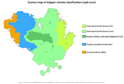
[[File:Esonice Köppen classification map.png|250px|thumb|{{wp|Köppen climate classification|Köppen climate classification}} map of Esonice]] | |||
===Humid subtropical=== | |||
Esonice's eastern and southern regions, which are located in the {{wp|humid subtropical|subtropical climate}} are the most wet parts of the country and include the majority of Esonice's {{wp|biodiversity|biodiversity}}. They include the majority of Esonice's total population at around 81%. | |||
Eastern & southern Esonice, unlike the north-west portion of the country, have 4 distinct seasonal variations. Those seasons are winter which characteristics consist of temperatures are colder than most of the year and less amounts of rain. Spring or what in Esonice it is known as the 'floral bloom' season were flowers across the nation start blooming. Summer which characteristics consist of warm to hot temperatures and mass amounts of rainfall, this is were the Esonian [[Geography of Esonice#psuedo-monsoons|psuedo monsoons]] take place in the year. | |||
{{Template:Eastern Esonian climate data}} | |||
===Subtropical highlands=== | ===Subtropical highlands=== | ||
| Line 36: | Line 127: | ||
===Fruits and vegetables=== | ===Fruits and vegetables=== | ||
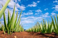
[[File:Aloe Vera plantation.jpeg|200px|thumb|{{wp|Aloe Vera|Aloe Vera}} plantation in ---, important in medicine and Esonian cuisine]] | |||
==Natural resources== | ==Natural resources== | ||
===Gem deposits=== | |||
==Natural hazards== | ==Natural hazards== | ||
=== | ===Esonian psuedo-monsoons=== | ||
===Earthquakes and tsunamis=== | |||
===Sandstorms=== | |||
{{Eurth}} | |||
[[Category:Esonice]] | [[Category:Esonice]] | ||
[[Category:Countries]] | [[Category:Countries]] | ||
[[Category:Alharu]] | [[Category:Alharu]] | ||
Latest revision as of 15:30, 22 January 2023
| Continent | Alharu |
|---|---|
| Region | West Alharu, Eastern Thalassa |
| Area | |
| • Total | 354,835 km2 (137,003 sq mi) |
| Largest lake | Lake Gamari |
| Climate | Varied; Wet subtropical to the east, transitioning in the west to tropical savannah, and then dry semi-arid to the north western coasts, with mountainous places being subtropical oceanic climates with rare snow |
| Terrain | mainly flat with volcanic and mountainous features |
| Natural Resources | Large deposits of various gems, marine life and mineral resources in territorial waters, deposits of iron, gold, silver, zinc, copper and minerals on land, including kaolin, marble and limestone |
| Natural Hazards | volcanic eruptions, sandstorms, tsunamis, eurthquakes, psuedo monsoons, droughts |
| Environmental Issues | air pollution; deforestation; overfishing; desertification; acidification of lakes and reservoirs; endangered wildlife |
Esonice is an island nation situated in the Esonian archipelago, surrounded by the Tiauhai Sea, which Esonians call 'the Sea of the Moon' (Esonian: Motsu no Koshin) and the Sea of the Rising Sun (Esonian: Motsu no ---) in the North Oriental Ocean, compromising of an archipelago of 4 major islands, 3 minor islands and --- smaller islands. The major island Esonice occupies is the island of Hirosho, which is the biggest island in the archipelago, and two smaller but noticeable islands in the south that are the islands of Mibiveshi and Lisharishi. All together, Esonice holds 254 in its possession; but only 20 of those are inhabited permanently. There are 234 remote islands with no inhabitants, 48 of those were turned into protected wildlife reserves.
All together, Esonice's territory covers 354,835 km2 (137,003 sq mi), making it the - largest island nation, and the - largest nation in the wulrd. It is the 2nd largest island nation in both Alharu and Thalassa.
Regions & provinces
Esonice has historically been divided into 8 regions, those regions being:
- Vellisia(Velisya
- Yatoshi
- Dahomi
- Alodia(Alodya)
- Juraba
- Chiyashi
- Kumiko
- ---
Topography, geology and geographical features

Lakes
| Rank | Name |
Region |
Type | Water | Area (km2) |
Max Depth (m) |
|---|---|---|---|---|---|---|
| 1 | Gamari yeshō | Velisya | Ancient lake, tectonic, freshwater | Fresh | 2,137 | 107 |
| 2 | Nandan yeshō | Yatoshi | freshwater | Fresh | --- | --- |
Rivers
| Rank | Name |
Region |
Length (sq2) |
|---|---|---|---|
| 1 | --- | --- |
Tectonic plates
Volcanos
Islands
| Rank | Name |
Area (km2) |
|---|---|---|
| 1 | Hirosho | 350,187 |
| 2 | Mibiveshi | 2,319 |
| 3 | Lisharishi | 2,328 |
| 4 | Katomei | --- |
| 5 | Makoshi | --- |
Population distribution
The 3 clusters
Climate

Humid subtropical
Esonice's eastern and southern regions, which are located in the subtropical climate are the most wet parts of the country and include the majority of Esonice's biodiversity. They include the majority of Esonice's total population at around 81%.
Eastern & southern Esonice, unlike the north-west portion of the country, have 4 distinct seasonal variations. Those seasons are winter which characteristics consist of temperatures are colder than most of the year and less amounts of rain. Spring or what in Esonice it is known as the 'floral bloom' season were flowers across the nation start blooming. Summer which characteristics consist of warm to hot temperatures and mass amounts of rainfall, this is were the Esonian psuedo monsoons take place in the year.
| Climate data for Eastern Esonice | |||||||||||||
|---|---|---|---|---|---|---|---|---|---|---|---|---|---|
| Month | Jan | Feb | Mar | Apr | May | Jun | Jul | Aug | Sep | Oct | Nov | Dec | Year |
| Average high °C (°F) | 21 (70) |
23 (73) |
25 (77) |
32 (90) |
31 (88) |
32 (90) |
37 (99) |
34 (93) |
33 (91) |
32 (90) |
31 (88) |
27 (81) |
30 (86) |
| Daily mean °C (°F) | 14 (57) |
15 (59) |
18 (64) |
22 (72) |
26 (79) |
28 (82) |
29 (84) |
29 (84) |
27 (81) |
27 (81) |
24 (75) |
20 (68) |
16 (61) |
| Average low °C (°F) | 8 (46) |
9 (48) |
11 (52) |
15 (59) |
18 (64) |
19 (66) |
20 (68) |
22 (72) |
18 (64) |
16 (61) |
12 (54) |
10 (50) |
8 (46) |
| Average rainfall mm (inches) | 45.32 (1.78) |
48.43 (1.91) |
48.97 (1.93) |
100.64 (3.96) |
122.42 (4.82) |
432.83 (17.04) |
328.38 (12.93) |
248.72 (9.79) |
168.23 (6.62) |
118.85 (4.68) |
87.65 (3.45) |
60.23 (2.37) |
1,810.67 (71.28) |
| Average rainy days | 7 | 7 | 8 | 10 | 13 | 23 | 21 | 17 | 14 | 12 | 10 | 9 | 151 |
| Average relative humidity (%) | 72 | 74 | 76 | 80 | 81 | 93 | 88 | 86 | 83 | 78 | 75 | 73 | 80 |
| Mean monthly sunshine hours | 221.3 | 215.7 | 212.2 | 192.8 | 142.4 | 58.5 | 67.8 | 134.4 | 172.7 | 197.3 | 202.5 | 211.2 | 2,028.8 |
| Source 1: Esonian atmospheric science department (EASD) | |||||||||||||
| Source 2: Esostatics weather statistics | |||||||||||||
Subtropical highlands
Tropical savannah
Semi-arid
Rainfall
Fauna
Land
Marine
Flora
Flowers
Fruits and vegetables
