Wajoka: Difference between revisions
mNo edit summary |
m (code cleanup) |
||
| (3 intermediate revisions by the same user not shown) | |||
| Line 1: | Line 1: | ||
{{Infobox country | {{Infobox country | ||
|micronation = <!--yes if a micronation--> | |micronation = <!--yes if a micronation--> | ||
|conventional_long_name = {{PAGENAME}} <!--Formal or official full name of the country in English--> | |conventional_long_name = Himaya of {{PAGENAME}} <!--Formal or official full name of the country in English--> | ||
|native_name = <!--Country's name (usually full name) in its native language, hence in italics (double quotemarks)--> | |native_name = <!--Country's name (usually full name) in its native language, hence in italics (double quotemarks)--> | ||
|common_name = {{PAGENAME}} <!--Common name in English (used for wikilinks, captions, and to produce a default iso3166 code)--> | |common_name = {{PAGENAME}} <!--Common name in English (used for wikilinks, captions, and to produce a default iso3166 code)--> | ||
| Line 11: | Line 11: | ||
|alt_flag2 = <!--alt text for second flag--> | |alt_flag2 = <!--alt text for second flag--> | ||
|flag2_border = <!--set to no to disable border around the flag--> | |flag2_border = <!--set to no to disable border around the flag--> | ||
|image_coat = <!--e.g. Coat of arms of country.svg--> | |image_coat = Featheredserpentnotchedplatevol2mississip86.png <!--e.g. Coat of arms of country.svg--> | ||
|alt_coat = <!--alt text for coat of arms--> | |alt_coat = <!--alt text for coat of arms--> | ||
|symbol_type = <!--emblem, seal, etc (if not a coat of arms)--> | |symbol_type = <!--emblem, seal, etc (if not a coat of arms)--> | ||
| Line 21: | Line 21: | ||
|other_symbol_type = <!--Use if a further symbol exists, e.g. hymn--> | |other_symbol_type = <!--Use if a further symbol exists, e.g. hymn--> | ||
|other_symbol = | |other_symbol = | ||
|image_map = | |image_map = <!--e.g. LocationCountry.svg--> | ||
|loctext = <!--text description of location of country--> | |loctext = <!--text description of location of country--> | ||
|alt_map = Map of {{PAGENAME}} <!--alt text for map--> | |alt_map = Map of {{PAGENAME}} <!--alt text for map--> | ||
| Line 33: | Line 33: | ||
|largest_settlement_type = <!--Type of settlement if largest settlement not a city--> | |largest_settlement_type = <!--Type of settlement if largest settlement not a city--> | ||
|largest_settlement = <!--Name of largest settlement--> | |largest_settlement = <!--Name of largest settlement--> | ||
|official_languages = <!--Languages recognised in legislation, constitution, etc--> | |official_languages = {{wp|Chaga languages|Kijoka}} <!--Languages recognised in legislation, constitution, etc--> | ||
|national_languages = <!--Country/territory-wide languages recognised but not necessarily in country/territory-wide law, etc--> | |national_languages = <!--Country/territory-wide languages recognised but not necessarily in country/territory-wide law, etc--> | ||
|regional_languages = <!--Languages recognised or associated with particular regions within the country/territory--> | |regional_languages = <!--Languages recognised or associated with particular regions within the country/territory--> | ||
| Line 48: | Line 48: | ||
|religion_year = <!--Year of religion data (if provided)--> | |religion_year = <!--Year of religion data (if provided)--> | ||
|religion_ref = <!--(for any ref/s to associate with religion data)--> | |religion_ref = <!--(for any ref/s to associate with religion data)--> | ||
|demonym = <!--Term/s describing those associated with the country/territory (e.g. "Belgian" for the country Belgium)--> | |demonym = Wajokan <!--Term/s describing those associated with the country/territory (e.g. "Belgian" for the country Belgium)--> | ||
|government_type = <!--(often a compound multi-wikilinked term, e.g. "Federal semi-presidential constitutional republic", etc)--> | |government_type = [[Himaya]] <!--(often a compound multi-wikilinked term, e.g. "Federal semi-presidential constitutional republic", etc)--> | ||
|leader_title1 = <!--(for a country, usually the head of state's (wikilinked) title, e.g. "President", "Monarch")--> | |leader_title1 = <!--(for a country, usually the head of state's (wikilinked) title, e.g. "President", "Monarch")--> | ||
|leader_name1 = | |leader_name1 = | ||
| Line 78: | Line 78: | ||
|area_label2 = <!--Label below area_label (optional)--> | |area_label2 = <!--Label below area_label (optional)--> | ||
|area_data2 = <!--Text after area_label2 (optional)--> | |area_data2 = <!--Text after area_label2 (optional)--> | ||
|population_estimate = | |population_estimate = 10,494,000 | ||
|population_estimate_rank = | |population_estimate_rank = | ||
|population_estimate_year = | |population_estimate_year = | ||
| Line 141: | Line 141: | ||
== Etymology == | == Etymology == | ||
The name of which comes from the phrase ''Wapanda farasi wa Joka'' (“Riders of the Dragon”).<ref name= | The name of which comes from the phrase ''Wapanda farasi wa Joka'' (“Riders of the Dragon”).<ref name='rework'>[https://www.europans.com/topic/6188-v5-map-europa-discussion/#comment-40017710 Phase 2.3 – Nation Change List] (30 July 2021)</ref> | ||
== Geography == | == Geography == | ||
Wajoka is divided by the northern lightly populated desert and the central and southern savannah grasslands. In the south along the south-central valley are long stretches of savannah forests where much of the population and urbanisation of the country is found, along with the capital of Mungumji (City of Mungu/God).<ref name= | Wajoka is divided by the northern lightly populated desert and the central and southern savannah grasslands. In the south along the south-central valley are long stretches of savannah forests where much of the population and urbanisation of the country is found, along with the capital of Mungumji (City of Mungu/God).<ref name='rework'/> | ||
(WIP. Landscape. Climate. Where exactly is your country compared to others on the global map? Describe the landscape, plants, and animals. Which mountains and rivers are important to include? Describe are the climate and seasons? How does geography determine where people live? Are there areas separated from one another? How about cities? This will greatly help you with the next part of history.) | (WIP. Landscape. Climate. Where exactly is your country compared to others on the global map? Describe the landscape, plants, and animals. Which mountains and rivers are important to include? Describe are the climate and seasons? How does geography determine where people live? Are there areas separated from one another? How about cities? This will greatly help you with the next part of history.) | ||
<gallery> | <gallery> | ||
Map of {{PAGENAME}}.png|Map of {{PAGENAME}}. | |||
Komodo Dragon AdF.jpg|{{wp|Komodo dragon|Holado dragon}}, a large species of lizard, is native to the country. | |||
Example.jpg|Caption. | Example.jpg|Caption. | ||
Example.jpg|Caption. | Example.jpg|Caption. | ||
| Line 158: | Line 158: | ||
== History == | == History == | ||
{{multiple image | |||
| align = right | |||
| total_width = 300 | |||
| image_style = border:none; | |||
| title = | |||
| perrow = 2/2 | |||
| caption_align = center | |||
| image1 = Chongoni Rock-Art Area-110124.jpg | |||
| caption1 = Early {{wp|Chongoni Rock Art Area|rock art}}. | |||
| image2 = Teotihuacan Feathered Serpent (Jami Dwyer).jpg | |||
| caption2 = Dragon heads cover a temple in N'Vava. | |||
| image3 = Xiuhcoatl British Museum.jpg | |||
| caption3 = Dragon sculpture from N'Vava, now in the Gallambrian Museum. | |||
| image4 = Maria-Popovi Avanyu plate MRM.jpeg | |||
| caption4 = Modern pottery with Dragon motif. | |||
}} | |||
(WIP.) | (WIP.) | ||
| Line 167: | Line 184: | ||
* 1413 — However once it reached it's current modern borders by 1413, Wa Joka fell into a lull of territorial isolationism, only allowing foreigners into the country if they were merchants or diplomats. | * 1413 — However once it reached it's current modern borders by 1413, Wa Joka fell into a lull of territorial isolationism, only allowing foreigners into the country if they were merchants or diplomats. | ||
* 1800s — Even through the late modern period Wajoka (as it began to be called) remained semi-isolationist as a culture and as a people, only attempting to conquer Cabarria twice in 1849 and 1871. | * 1800s — Even through the late modern period Wajoka (as it began to be called) remained semi-isolationist as a culture and as a people, only attempting to conquer Cabarria twice in 1849 and 1871. | ||
* 2000s — It was only the arrival of the Europan | * 2000s — It was only the arrival of the [[Great Europan Collapse]] in the mid-2000s did Wajoka stir. The country was one of the few economically stable states due to its few connections to the outside wurld. Wajoka found itself as a new potential player in [[Azania]]n and even [[Adlantic]] politics, although has only made small moves in the form of expanding trade. Although with a growing urbanising population, if Wajoka was to ever seek out a modern empire. Now is the time.<ref name='rework'/> | ||
== Politics == | == Politics == | ||
| Line 184: | Line 201: | ||
}} | }} | ||
Wajoka is, by law, a Himaya, and does divide its empire into 12 tributaries and only the south-central valley being 'core Wa Joka'. But the nation is largely democratic and equal due to the little differences in culture between central Wa Joka and the wider Wajokan population. Every 8 years the population votes for members of the Tributary Council, a parliament/senate like body that acts as the main judiciary and legislative body of the Himaya. The Emperor of Wajoka rarely intervenes in politics, preferring to take a constitutional role in the nation.<ref name= | Wajoka is, by law, a Himaya, and does divide its empire into 12 tributaries and only the south-central valley being 'core Wa Joka'. But the nation is largely democratic and equal due to the little differences in culture between central Wa Joka and the wider Wajokan population. Every 8 years the population votes for members of the Tributary Council, a parliament/senate like body that acts as the main judiciary and legislative body of the Himaya. The Emperor of Wajoka rarely intervenes in politics, preferring to take a constitutional role in the nation.<ref name='rework'/> | ||
(WIP. Government. Separation of powers. Who rules, how, and for how long? Political parties. What levels of government exist? How about the local level? Who makes the laws? Who deals out your justice? Which government services exist? What is the name of your police? How are the armed forces organised? Foreign affairs, alliances, membership of international organisations.) | (WIP. Government. Separation of powers. Who rules, how, and for how long? Political parties. What levels of government exist? How about the local level? Who makes the laws? Who deals out your justice? Which government services exist? What is the name of your police? How are the armed forces organised? Foreign affairs, alliances, membership of international organisations.) | ||
| Line 192: | Line 209: | ||
A large proportion of Wajoka’s economy is derived from plant and pulp export, along with wood from its massive logging and palm oil / Soybean plantations. Much of it’s original Savannah forests have been deforested and replaced with said plantations. A secondary export is of dyes, particularly a very intense black dye used for ink pens, known as Joka Black. | A large proportion of Wajoka’s economy is derived from plant and pulp export, along with wood from its massive logging and palm oil / Soybean plantations. Much of it’s original Savannah forests have been deforested and replaced with said plantations. A secondary export is of dyes, particularly a very intense black dye used for ink pens, known as Joka Black. | ||
Wajoka is known to have large untapped oil reserves, with only 10% of it being actively drilled for.<ref name= | Wajoka is known to have large untapped oil reserves, with only 10% of it being actively drilled for.<ref name='rework'/> | ||
(WIP. Employment. Exports and imports. International partners. Currency. Energy. Transportation. Science & technology. Unemployment numbers. Tourism. Media.) | (WIP. Employment. Exports and imports. International partners. Currency. Energy. Transportation. Science & technology. Unemployment numbers. Tourism. Media.) | ||
| Line 201: | Line 218: | ||
* Primarily based off the {{wp|Swahili people}}, although replace Arabic influence with Latin from the [[Aroman Empire]] and English from [[Cabarria]]. | * Primarily based off the {{wp|Swahili people}}, although replace Arabic influence with Latin from the [[Aroman Empire]] and English from [[Cabarria]]. | ||
* The Wajokans follow a faith called Wajism, which can be summed up to be in a belief in a great eastern city, home to the Gods, situated where the Sun rises from the Eurth every day. It is fabled the sun’s rise comes out of some far eastern mountains known only as the ''Milima ya Mungu'' (“God’s Mountains”).<ref name= | * The Wajokans follow a faith called Wajism, which can be summed up to be in a belief in a great eastern city, home to the Gods, situated where the Sun rises from the Eurth every day. It is fabled the sun’s rise comes out of some far eastern mountains known only as the ''Milima ya Mungu'' (“God’s Mountains”).<ref name='rework'/> | ||
* | * Demographics shows two distinct cultural groups: | ||
** Inland dwellers: {{wp|Chaga people}}. | |||
** Seafaring: {{wp|Chagossians}} | |||
* Language | |||
** Person: Mjoka | |||
** People: Wajoka | |||
** Language: {{wp|Chaga languages|Kijoka language}} | |||
(WIP. Demographics. Ethnic groups. Social classes. Language. Education. Marriage. Religion. Healthcare. Diseases.) | (WIP. Demographics. Ethnic groups. Social classes. Language. Education. Marriage. Religion. Healthcare. Diseases.) | ||
| Line 212: | Line 235: | ||
OOC | OOC | ||
* Describe the RL subculture of nouveau riche {{wp|WaBenzi}}. | * Describe the RL subculture of nouveau riche {{wp|WaBenzi}}.<ref name='rework'/> | ||
== WIP sources == | |||
* Intro: https://www.europans.com/topic/916-the-nomadic-peoples-of-dragonryders/ | |||
* History: https://www.europans.com/topic/1769-the-treaty-of-a-thousand-years-ends/ | |||
* Military: https://www.europans.com/topic/1026-weaponry-catalogue/ | |||
* Media: https://www.europans.com/topic/1014-monswe-elor-regional-newspaper/ | |||
== References == | == References == | ||
Latest revision as of 18:00, 3 February 2024
Himaya of Wajoka | |
|---|---|
 Flag
 Coat of arms
| |
| Capital | Mungumji |
| Official languages | Kijoka |
| Demonym(s) | Wajokan |
| Government | Himaya |
| Legislature | Tributary Council |
| Population | |
• Estimate | 10,494,000 |
This article or section is in the process of an expansion or major restructuring. You are welcome to assist in its construction by editing it as well. If this article or section has not been edited in several days, please remove this template. If you are the editor who added this template and you are actively editing, please be sure to replace this template with {{in use}} during the active editing session. Click on the link for template parameters to use.
This article was last edited by Orioni (talk | contribs) 3 months ago. (Update timer) |
Wajoka, officially known as the NATIONTYPE of Wajoka, is a sovereign state in CONTINENT on Eurth. It is bordered by Zharr and Cabarria in the east, and Faramount and Noble Nykia to the south.
(1st paragraph. Name. Location. Borders. Approx population and size. Capital city.)
(2nd paragraph. Political system. Short history in 1 sentence. Link with present in 1 sentence. Head of state.)
(3rd paragraph. Economy in 2 sentences. International relations in 1 sentence.)
Etymology
The name of which comes from the phrase Wapanda farasi wa Joka (“Riders of the Dragon”).[1]
Geography
Wajoka is divided by the northern lightly populated desert and the central and southern savannah grasslands. In the south along the south-central valley are long stretches of savannah forests where much of the population and urbanisation of the country is found, along with the capital of Mungumji (City of Mungu/God).[1]
(WIP. Landscape. Climate. Where exactly is your country compared to others on the global map? Describe the landscape, plants, and animals. Which mountains and rivers are important to include? Describe are the climate and seasons? How does geography determine where people live? Are there areas separated from one another? How about cities? This will greatly help you with the next part of history.)
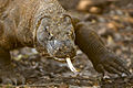
Holado dragon, a large species of lizard, is native to the country.

Caption.
Caption.
Caption.


History

.jpg)


(WIP.)
- Ancient history — Wajoka is an ancient power in Azania, with records of past Wajokan empires existing as far back as Aroman records.
- Medieval — Pre-1000s Wajoka was considered an expansionary power often attempted to conquer and annexed Cabarria and down south into modern day Faramount and Afropa.
- 1100s — However past 1100 the Wajokan Himayas collapsed into infighting and eventually completely dissolved into smaller tribal states.
- 1300s — From the early 1300s to early 1400s a new power, calling itself Wa Joka ("The Dragon") begin to rise out of the ashes of the dead Himayas to begin the reconquest and reformation of the Wajoka Himaya.
- 1413 — However once it reached it's current modern borders by 1413, Wa Joka fell into a lull of territorial isolationism, only allowing foreigners into the country if they were merchants or diplomats.
- 1800s — Even through the late modern period Wajoka (as it began to be called) remained semi-isolationist as a culture and as a people, only attempting to conquer Cabarria twice in 1849 and 1871.
- 2000s — It was only the arrival of the Great Europan Collapse in the mid-2000s did Wajoka stir. The country was one of the few economically stable states due to its few connections to the outside wurld. Wajoka found itself as a new potential player in Azanian and even Adlantic politics, although has only made small moves in the form of expanding trade. Although with a growing urbanising population, if Wajoka was to ever seek out a modern empire. Now is the time.[1]
Politics

Wajoka is, by law, a Himaya, and does divide its empire into 12 tributaries and only the south-central valley being 'core Wa Joka'. But the nation is largely democratic and equal due to the little differences in culture between central Wa Joka and the wider Wajokan population. Every 8 years the population votes for members of the Tributary Council, a parliament/senate like body that acts as the main judiciary and legislative body of the Himaya. The Emperor of Wajoka rarely intervenes in politics, preferring to take a constitutional role in the nation.[1]
(WIP. Government. Separation of powers. Who rules, how, and for how long? Political parties. What levels of government exist? How about the local level? Who makes the laws? Who deals out your justice? Which government services exist? What is the name of your police? How are the armed forces organised? Foreign affairs, alliances, membership of international organisations.)
Economy
A large proportion of Wajoka’s economy is derived from plant and pulp export, along with wood from its massive logging and palm oil / Soybean plantations. Much of it’s original Savannah forests have been deforested and replaced with said plantations. A secondary export is of dyes, particularly a very intense black dye used for ink pens, known as Joka Black.
Wajoka is known to have large untapped oil reserves, with only 10% of it being actively drilled for.[1]
(WIP. Employment. Exports and imports. International partners. Currency. Energy. Transportation. Science & technology. Unemployment numbers. Tourism. Media.)
Demographics
OOC
- Primarily based off the Swahili people, although replace Arabic influence with Latin from the Aroman Empire and English from Cabarria.
- The Wajokans follow a faith called Wajism, which can be summed up to be in a belief in a great eastern city, home to the Gods, situated where the Sun rises from the Eurth every day. It is fabled the sun’s rise comes out of some far eastern mountains known only as the Milima ya Mungu (“God’s Mountains”).[1]
- Demographics shows two distinct cultural groups:
- Inland dwellers: Chaga people.
- Seafaring: Chagossians
- Language
- Person: Mjoka
- People: Wajoka
- Language: Kijoka language
(WIP. Demographics. Ethnic groups. Social classes. Language. Education. Marriage. Religion. Healthcare. Diseases.)
Cultures
(WIP. Cuisine. Literature. Visual arts. Art. Architecture. Entertainment. Music & Radio. Television. Cuisine. Local customs. Clothing. Morality. Sports. Stereotypes. Your national symbols such as the flag and national anthem. Public holidays and festivities.)
OOC
WIP sources
- Intro: https://www.europans.com/topic/916-the-nomadic-peoples-of-dragonryders/
- History: https://www.europans.com/topic/1769-the-treaty-of-a-thousand-years-ends/
- Military: https://www.europans.com/topic/1026-weaponry-catalogue/
- Media: https://www.europans.com/topic/1014-monswe-elor-regional-newspaper/
References
| History | |||||||||
|---|---|---|---|---|---|---|---|---|---|
| Continents & 133 Countries | |||||||||
| Geography |
| ||||||||
| Organisations |
| ||||||||
| Politics | |||||||||
| Law | |||||||||
| Military | |||||||||
| Economics | |||||||||
| Culture | |||||||||
| Sports | |||||||||