Ceris: Difference between revisions
(Created page with "'''Ceris''' is an island located in the Adlantic Ocean. It is bordered by the Dolch Sea and Argis to the north, the Qingming Sea to the west, and Seylos to the east.") |
mNo edit summary |
||
| (8 intermediate revisions by 3 users not shown) | |||
| Line 1: | Line 1: | ||
'''Ceris''' is an island located in the [[Adlantic Ocean]]. It is bordered by the Dolch Sea and [[Argis]] to the north, the Qingming Sea to the west, and [[Seylos]] to the east. | {{Infobox islands | ||
| name = Ceris | |||
| native_name = <!-- or |local_name= --> | |||
| native_name_link = | |||
| native_name_lang = | |||
| sobriquet = <!-- or |nickname= --> | |||
| image_name = Map of Ceris.png | |||
| image_size = 200px | |||
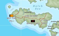
| image_caption = Map of Ceris | |||
| image_alt = Map of Ceris | |||
| image_map = | |||
| image_map_alt = | |||
| image_map_size = | |||
| image_map_caption = | |||
| pushpin_map = | |||
| pushpin_label = | |||
| pushpin_label_position = | |||
| pushpin_map_alt = | |||
| pushpin_relief = | |||
| pushpin_map_caption = | |||
| coordinates = <!-- {{coord|display=it}} --> | |||
| etymology = | |||
| location = [[Adlantic Ocean]]<!-- mandatory, body of water where located --> | |||
| grid_reference = <!-- UK only --> | |||
| archipelago = | |||
| waterbody = | |||
| total_islands = | |||
| major_islands = | |||
| area_km2 = <!-- or |area_m2= or |area_ha= --> | |||
| area_footnotes = | |||
| rank = | |||
| length_km = <!-- or |length_m= --> | |||
| length_footnotes = | |||
| width_km = <!-- or |width_m= --> | |||
| width_footnotes = | |||
| coastline_km = <!-- or |coastline_m= --> | |||
| coastline_footnotes = | |||
| elevation_m = | |||
| elevation_footnotes = | |||
| highest_mount = | |||
| country = <!-- mandatory --> | |||
| country_admin_divisions_title = | |||
| country_admin_divisions = | |||
| country_admin_divisions_title_1 = | |||
| country_admin_divisions_1 = | |||
| country_admin_divisions_title_2 = | |||
| country_admin_divisions_2 = | |||
| country_capital_type = | |||
| country_capital = | |||
| country_largest_city_type = | |||
| country_largest_city = | |||
| country_capital_and_largest_city = | |||
| country_largest_city_population = | |||
| country_leader_title = | |||
| country_leader_name = | |||
| country_area_km2 = <!-- or |country_area_m2= or |country_area_ha= --> | |||
| country1 = | |||
| country1_admin_divisions_title = | |||
| country1_admin_divisions = | |||
| country1_admin_divisions_title_1 = | |||
| country1_admin_divisions_1 = | |||
| country1_capital_type = | |||
| country1_capital = | |||
| country1_largest_city_type = | |||
| country1_largest_city = | |||
| country1_capital_and_largest_city = | |||
| country1_largest_city_population = | |||
| country1_leader_title = | |||
| country1_leader_name = | |||
| country1_area_km2 = <!-- or |country1_area_m2= or |country1_area_ha= --> | |||
| demonym = | |||
| population = | |||
| population_as_of = | |||
| population_footnotes = | |||
| population_rank = | |||
| population_rank_max = | |||
| density_km2 = | |||
| density_rank = | |||
| density_footnotes = | |||
| languages = Anglish, Dolch | |||
| ethnic_groups = | |||
| timezone1 = | |||
| utc_offset1 = | |||
| timezone1_DST = | |||
| utc_offset1_DST = | |||
| website = | |||
| additional_info = | |||
| footnotes = | |||
}} | |||
{{wip}} | |||
'''Ceris''' is an island located in the [[Adlantic Ocean]]. It is bordered by the [[Dolch Sea]] and [[Argis]] to the north, the [[Qingming Sea]] to the west, and [[Seylos]] to the east. | |||
Ceris is notably overpopulated, with famine, disease, poverty and conflict becoming ever more rampant, though international efforts following the [[Sentist War]] are working to end this, Ceris remains a region with low living standards, and migrations from the island are common. | |||
==Countries== | |||
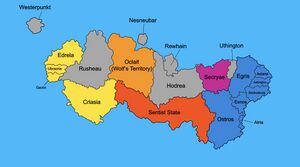
[[File:Political_map_of_ceris.jpg|right|thumb|Politcal map of Ceris.]] | |||
Ceris is home to over a dozen nations, many of which are part of either the [[North Adlantic Union]] or the West Ceris Federation. | |||
*[[North Adlantic Union]] | |||
**Ashington | |||
**Astaria | |||
**Atrya | |||
**Cenia | |||
**Corinium | |||
**Egris | |||
**Esnos | |||
**Ostros | |||
**Seskoaburg | |||
*[[West Ceris Federation]] | |||
**Criasia | |||
**Edrela | |||
**Ganlin | |||
**Ubraoria | |||
*[[Hodrea]] | |||
*Nesneubar | |||
*Oclait | |||
*Rewhain | |||
*Rusheau | |||
*[[Secryae]] | |||
*Uthington | |||
*Westerpunkt | |||
Nesneubar and Westerpunkt are not located on mainland Ceris, however are generally considered to be Ceriser countries. | |||
The [[Sentist State]] controls a large portion of Ceris, however is internationally unrecognised, as it is designated a terrorist group, and is responsible for the [[Sentist War]]. | |||
[[Category:Ceris]] | |||
{{Eurth}} | |||
Latest revision as of 03:40, 18 September 2022
 Map of Ceris | |
| Geography | |
|---|---|
| Location | Adlantic Ocean |
| Demographics | |
| Languages | Anglish, Dolch |
This article is incomplete because it is pending further input from participants, or it is a work-in-progress by one author. Please comment on this article's talk page to share your input, comments and questions. Note: To contribute to this article, you may need to seek help from the author(s) of this page. |
Ceris is an island located in the Adlantic Ocean. It is bordered by the Dolch Sea and Argis to the north, the Qingming Sea to the west, and Seylos to the east.
Ceris is notably overpopulated, with famine, disease, poverty and conflict becoming ever more rampant, though international efforts following the Sentist War are working to end this, Ceris remains a region with low living standards, and migrations from the island are common.
Countries
Ceris is home to over a dozen nations, many of which are part of either the North Adlantic Union or the West Ceris Federation.
- North Adlantic Union
- Ashington
- Astaria
- Atrya
- Cenia
- Corinium
- Egris
- Esnos
- Ostros
- Seskoaburg
- West Ceris Federation
- Criasia
- Edrela
- Ganlin
- Ubraoria
- Hodrea
- Nesneubar
- Oclait
- Rewhain
- Rusheau
- Secryae
- Uthington
- Westerpunkt
Nesneubar and Westerpunkt are not located on mainland Ceris, however are generally considered to be Ceriser countries.
The Sentist State controls a large portion of Ceris, however is internationally unrecognised, as it is designated a terrorist group, and is responsible for the Sentist War.
