Ruvian Autonomy: Difference between revisions
m (→Municipalities) |
mNo edit summary |
||
| (2 intermediate revisions by the same user not shown) | |||
| Line 19: | Line 19: | ||
| capital = [[Nebel]] | | capital = [[Nebel]] | ||
| largest_settlement = capital | | largest_settlement = capital | ||
| official_languages = | | official_languages = {{wpl|Frisian languages|Ruvian}} | ||
| ethnic_groups = {{hlist|[[Ethnic_groups_in_Littland#Ruvians|Ruvians]]|[[Ethnic_groups_in_Littland#Litts|Litts | | ethnic_groups = {{hlist|[[Ethnic_groups_in_Littland#Ruvians|Ruvians]]|[[Ethnic_groups_in_Littland#Litts|Litts]]}} | ||
| demonym = Ruvian | | demonym = Ruvian | ||
| government_type = {{wpl|Devolution|Devolved region}} within a {{wpl|Parliamentary system|parliamentary}} {{wpl|republic}} | | government_type = {{wpl|Devolution|Devolved region}} within a {{wpl|Parliamentary system|parliamentary}} {{wpl|republic}} | ||
| Line 26: | Line 26: | ||
| leader_name1 = [[Roan Baarda]] | | leader_name1 = [[Roan Baarda]] | ||
| legislature = [[Ruvian Council]] | | legislature = [[Ruvian Council]] | ||
| area_km2 = | | area_km2 = 10939 | ||
| area_sq_mi = auto | | area_sq_mi = auto | ||
| population_estimate = 2,248,000 | | population_estimate = 2,248,000 | ||
| population_estimate_year = 2021 | | population_estimate_year = 2021 | ||
| population_density_km2 = | | population_density_km2 = 205 | ||
| population_density_sq_mi = auto | | population_density_sq_mi = auto | ||
| GDP_nominal = 26.62 billion [[wikipedia:United States dollar|{{Hover title|dotted=no|Adapton Solidus|AD$}}]] | | GDP_nominal = 26.62 billion [[wikipedia:United States dollar|{{Hover title|dotted=no|Adapton Solidus|AD$}}]] | ||
| Line 42: | Line 42: | ||
| HDI_change = increase | | HDI_change = increase | ||
}} | }} | ||
The '''Ruvian Autonomy''' ({{wpl|Frisian languages|Ruvian}}: ''Ruvii Selsbestjoer'', {{wpl|Danish language|Littish}}: ''Ruviske Selvstyre'') or simply '''Ruvia''', is an {{wpl|autonomous}} region of [[Littland]] since 2004. It is inhabited by the [[Ethnic groups in Littland#Ruvians|Ruvian]] {{wpl|ethnic group}} with the offical | The '''Ruvian Autonomy''' ({{wpl|Frisian languages|Ruvian}}: ''Ruvii Selsbestjoer'', {{wpl|Danish language|Littish}}: ''Ruviske Selvstyre'') or simply '''Ruvia''', is an {{wpl|autonomous}} region of [[Littland]] since 2004. It is inhabited by the [[Ethnic groups in Littland#Ruvians|Ruvian]] {{wpl|ethnic group}} with the offical language being {{wpl|Frisian language|Ruvian}}. It covers an area of 9,596 square kilometers (3,705 sq mi) and has a population of 2,248,000 as of 2021. Ruvia is situated in the southern part of Littland, located along the [[Memmert Mountains]]. Over 32% of the population lives in the capital city of [[Nebel]], where the [[Ruvian Council]], acting as the regions parliament, resides. | ||
==History== | ==History== | ||
| Line 54: | Line 54: | ||
After the Civil War, rights for Ruvians and the recognition of majority-Ruvian areas were incorporated into the Constitution. | After the Civil War, rights for Ruvians and the recognition of majority-Ruvian areas were incorporated into the Constitution. | ||
In November 2003 a referendum for a new Constitution was held, with the major change being the establishment of a Ruvian autonomous region. The referendum passed with 68.6% voting for it and on 1 | In November 2003 a referendum for a new Constitution was held, with the major change being the establishment of a Ruvian autonomous region. The referendum passed with 68.6% voting for it and on 1 August 2004, the Ruvian Autonomy was established. | ||
==Geography== | ==Geography== | ||
{{See also|Geography of Littland}} | {{See also|Geography of Littland}} | ||
[[File:Velky_a_Maly_Roudny02.JPG|left|thumb|210px|Memmert Mountains|link=Geography of Littland]] | |||
The Ruvian Autonomy covers an area of 9,596 square kilometers (3,705 sq mi). Over 32% of the population lives within the capital of [[Nebel]]. The Ruvian landscape is characterized by the [[Memmert Mountains]], a mountain range that goes through a majority of the Ruvian Autonomy and parts of Littland. The highest point is "Sinneberch" (Sun Mountain) 793m above sea level, located north of [[Leens]]. The highlands of the mountains are drained by various smaller streams which runs into the [[Arup River]]. | |||
The climate in Ruvia is similar to the rest of Littland, having a {{wpl|Humid continental climate|temperate climate}} with cold winters warm summers. Due to its mountainous terrain, on average the temperature is lower in Ruvia than the rest of Littland. A large part of Ruvia is covered in forest, with only around 30% suitable for large scale agriculture. Many natural resources can be found in the mountains, {{wpl|lignite}}, {{wpl|graphite}} and {{wpl|coal}}. Over 70% of electricity produced from coal in Littland comes from coal mined in the [[Memmert Mountains|Memmerts]]. | |||
==Politics== | ==Politics== | ||
| Line 71: | Line 75: | ||
| caption2 = [[Littish Passport]] issued in the Ruvian Autonomy | | caption2 = [[Littish Passport]] issued in the Ruvian Autonomy | ||
}} | }} | ||
The Ruvian Autonomy is governed in accordance with Section 70 of the [[Constitution of Littland]], which guarantee the regions autonomy and the powers of the [[Ruvian Council]] and the [[Premier of Ruvia]], who acts as the government. Additionally the 'Act on Ruvian Autonomy and Status in Littish Politics' from 2008 further grants the region lawmaking power within certain areas such as education, social affairs and environment. The Act also gave parties in the Council the ability to stand for [[Folkekammer]] elections without the need to go through the normal process Littish parties have to. This has happened a few times, with | The Ruvian Autonomy is governed in accordance with Section 70 of the [[Constitution of Littland]], which guarantee the regions autonomy and the powers of the [[Ruvian Council]] and the [[Premier of Ruvia]], who acts as the government. Additionally the 'Act on Ruvian Autonomy and Status in Littish Politics' from 2008 further grants the region lawmaking power within certain areas such as education, social affairs and environment. The Act also gave parties in the Council the ability to stand for [[Folkekammer]] elections without the need to go through the normal process Littish parties have to. This has happened a few times, with the [[Ruvian National Party|National Party]], [[Ruvian Social Democrats|Social Democrats]] and [[People's Party of Ruvia|People's Party]] coming together to campaign as the [[Party for Ruvia]], it currently has no seats in the current Folkekammer. | ||
Since 2008 the Ruvian Autonomy has had its own flag and issued its own variant of the Littish passport. It also its own police force and law enforcement, but is a demilitarized area due to history of Littish oppression using the [[Forsvarsstyrken|Armed Forces]]. Before conscription was abolished in 2006, Ruvians were exempt from military service but could still volunteer. | Since 2008 the Ruvian Autonomy has had its own flag and issued its own variant of the Littish passport. It also its own police force and law enforcement, but is a demilitarized area due to history of Littish oppression using the [[Forsvarsstyrken|Armed Forces]]. Before conscription was abolished in 2006, Ruvians were exempt from military service but could still volunteer. | ||
| Line 118: | Line 122: | ||
===Municipalities=== | ===Municipalities=== | ||
{{See also|Administrative divisions of Littland}} | |||
There are 14 municipalities in the Ruvian Autonomy. | There are 14 municipalities in the Ruvian Autonomy. Over half of the population lives within the three largest cities, [[Borgsum]], [[Leens]] and the capital [[Nebel]] as of 2021. | ||
{{Div col|colwidth=15em}} | {{Div col|colwidth=15em}} | ||
* '''[[Nebel]]''' | * '''[[Nebel]]''' | ||
| Line 153: | Line 157: | ||
==Demographics== | ==Demographics== | ||
{{See also|Ethnic groups in Littland}} | {{See also|Ethnic groups in Littland}} | ||
[[File:Region Ruvian Decrease Map.png|right|thumb|400px|Areas inhabited by the Ruvian people over the last few centuries with borders of the Ruvian Autonomy shown.]] | [[File:Region Ruvian Decrease Map.png|right|thumb|400px|Areas inhabited by the Ruvian people over the last few centuries with borders of the Ruvian Autonomy shown.|link=Ethnic groups in Littland]] | ||
Most inhabitants speak {{wpl|Frisian languages|Ruvian}} as their first language, with 81% in 2020. The language in public schools is Ruvian, with Littish being a secondary school language. Despite there being over 4 million Ruvians in Littland, only roughly 1.9 million of them live in the Ruvian Autonomy. The rest is scattered across Littland with a considerable Ruvian exclave in the capital of [[Kaslund]]. | Most inhabitants speak {{wpl|Frisian languages|Ruvian}} as their first language, with 81% in 2020. The language in public schools is Ruvian, with Littish being a secondary school language. Despite there being over 4 million Ruvians in Littland, only roughly 1.9 million of them live in the Ruvian Autonomy. The rest is scattered across Littland with a considerable Ruvian exclave in the capital of [[Kaslund]]. | ||
{{Littland Navbox}} | {{Littland Navbox}} | ||
{{Eurth}} | {{Eurth}} | ||
Latest revision as of 13:04, 17 January 2023
Ruvian Autonomy | |
|---|---|
| Anthem: "Yn ús dellingen blau" (Ruvian) (English: "In our blue valleys") | |
 Location of the Ruvian Autonomy within Littland | |
| Sovereign state | Republic of Littland |
| Treaty of Kehlborg | 1702 |
| First Ruvian Council | 1809 |
| Autonomy Established | 1 August 2004 |
| Capital and largest city | Nebel |
| Official languages | Ruvian |
| Ethnic groups | |
| Demonym(s) | Ruvian |
| Government | Devolved region within a parliamentary republic |
• Premier | Roan Baarda |
| Legislature | Ruvian Council |
| Area | |
• Total | 10,939 km2 (4,224 sq mi) |
| Population | |
• 2021 estimate | 2,248,000 |
• Density | 205/km2 (530.9/sq mi) |
| GDP (nominal) | 2020 estimate |
• Total | 26.62 billion AD$ |
• Per capita | 11,841 AD$ |
| Gini (2021) | medium |
| HDI (2018) | high |
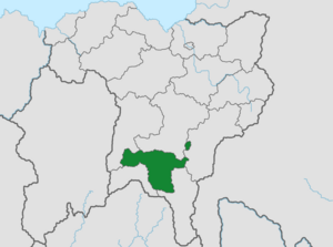
The Ruvian Autonomy (Ruvian: Ruvii Selsbestjoer, Littish: Ruviske Selvstyre) or simply Ruvia, is an autonomous region of Littland since 2004. It is inhabited by the Ruvian ethnic group with the offical language being Ruvian. It covers an area of 9,596 square kilometers (3,705 sq mi) and has a population of 2,248,000 as of 2021. Ruvia is situated in the southern part of Littland, located along the Memmert Mountains. Over 32% of the population lives in the capital city of Nebel, where the Ruvian Council, acting as the regions parliament, resides.
History
The Ruvians have been under control of Littland since the Treaty of Kehlborg in 1702.
The Ruvians first started coming together to discuss their place in Littland in the early 1800's, culminating in the First Ruvian Council in 1809. The Old Council as it's known, declared at Ruvians were different than Litts and as such, should be treated as such and with respect, dignity and care. Since 1702 Ruvians had seen oppression by ruling Littish monarchs.
The Dark Decade saw Ruvians oppressed by the Nordskov administration, deindustrializating the area and ignoring Ruvian pleas for political influence. During the Littish Civil War, the Old Council split over the issue of Nationalism or Socialism, with member unsure whether Ruvians had a better future as an independent state or under a socialist, and thus perceived, more equal Littland. This is still a topic of discussion today.
After the Civil War, rights for Ruvians and the recognition of majority-Ruvian areas were incorporated into the Constitution.
In November 2003 a referendum for a new Constitution was held, with the major change being the establishment of a Ruvian autonomous region. The referendum passed with 68.6% voting for it and on 1 August 2004, the Ruvian Autonomy was established.
Geography
The Ruvian Autonomy covers an area of 9,596 square kilometers (3,705 sq mi). Over 32% of the population lives within the capital of Nebel. The Ruvian landscape is characterized by the Memmert Mountains, a mountain range that goes through a majority of the Ruvian Autonomy and parts of Littland. The highest point is "Sinneberch" (Sun Mountain) 793m above sea level, located north of Leens. The highlands of the mountains are drained by various smaller streams which runs into the Arup River.
The climate in Ruvia is similar to the rest of Littland, having a temperate climate with cold winters warm summers. Due to its mountainous terrain, on average the temperature is lower in Ruvia than the rest of Littland. A large part of Ruvia is covered in forest, with only around 30% suitable for large scale agriculture. Many natural resources can be found in the mountains, lignite, graphite and coal. Over 70% of electricity produced from coal in Littland comes from coal mined in the Memmerts.
Politics
The Ruvian Autonomy is governed in accordance with Section 70 of the Constitution of Littland, which guarantee the regions autonomy and the powers of the Ruvian Council and the Premier of Ruvia, who acts as the government. Additionally the 'Act on Ruvian Autonomy and Status in Littish Politics' from 2008 further grants the region lawmaking power within certain areas such as education, social affairs and environment. The Act also gave parties in the Council the ability to stand for Folkekammer elections without the need to go through the normal process Littish parties have to. This has happened a few times, with the National Party, Social Democrats and People's Party coming together to campaign as the Party for Ruvia, it currently has no seats in the current Folkekammer.
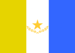
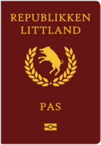
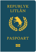
Since 2008 the Ruvian Autonomy has had its own flag and issued its own variant of the Littish passport. It also its own police force and law enforcement, but is a demilitarized area due to history of Littish oppression using the Armed Forces. Before conscription was abolished in 2006, Ruvians were exempt from military service but could still volunteer.
Parties
| Party | Council seats | Ideology | Leader | Comments | ||
|---|---|---|---|---|---|---|
| Ruvian National Party Ruvii Nasjonale Partij Det Ruviske National Parti |
15 / 45
|
Centre-right conservative party. In favor of staying with Littland. |
Roan Baarda | Sister party to the Christian Democrats | ||
| Ruvian Social Democrats Sosjaaldemokraten Ruviske Socialdemokrater |
13 / 45
|
Centre-left social democratic party. In favor of staying with Littland. |
Lourens Sjoerd | Sister party to the Labour Party | ||
| People's Party of Ruvia Folkspartij fan Ruvië Ruvisk Folkeparti |
9 / 45
|
Centrist party. In favor of greater autonomy. |
Pitter Tiede | |||
| Self Determination Party De Selsbeskikkingspartij Selvbestemmelsespartiet |
8 / 45
|
Catch-all nationalistic party. In favor of Ruvian independence. |
Fedde Dieuwer | Sometimes called the Independence Party | ||
Municipalities
There are 14 municipalities in the Ruvian Autonomy. Over half of the population lives within the three largest cities, Borgsum, Leens and the capital Nebel as of 2021.
- Nebel
- Population: 727,871
- Leens
- Population: 461,287
- Borgsum
- Population: 240,524
- Drage
- Population: 165,482
- Welt
- Population: 105,687
- Viöl
- Population: 103.751
- Hooge
- Population: 78,514
- Seeth
- Population: 76,418
- Stöde
- Population: 70,139
- Ockrup
- Population: 68,454
- Oldsum
- Population: 68,258
- Breküll
- Population: 67,985
- Arlelund
- Population: 59,784
- Engum
- Population: 53,516
Demographics
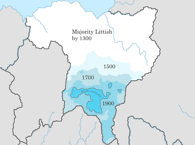
Most inhabitants speak Ruvian as their first language, with 81% in 2020. The language in public schools is Ruvian, with Littish being a secondary school language. Despite there being over 4 million Ruvians in Littland, only roughly 1.9 million of them live in the Ruvian Autonomy. The rest is scattered across Littland with a considerable Ruvian exclave in the capital of Kaslund.
