Geography of Littland: Difference between revisions
Jump to navigation
Jump to search
m (→Climate) |
mNo edit summary |
||
| (4 intermediate revisions by the same user not shown) | |||
| Line 19: | Line 19: | ||
==Topography== | ==Topography== | ||
===Islands=== | |||
== | ===Mountains=== | ||
===Rivers=== | |||
===National parks=== | |||
==Climate== | ==Climate== | ||
| Line 32: | Line 36: | ||
==Resources and land use== | ==Resources and land use== | ||
* '''Natural resources:''' | * '''Natural resources:''' {{wpl|coal}}, {{wpl|copper}}, {{wpl|iron}}, {{wpl|natural gas}}, {{wpl|limestone}}, timber, arable land | ||
* '''Land use:''' | * '''Land use:''' | ||
* '''{{wpl|Forests}} and {{wpl|woodlands}}:''' | * '''{{wpl|Forests}} and {{wpl|woodlands}}:''' | ||
* '''{{wpl|Irrigation|Irrigated}} land:''' | * '''{{wpl|Irrigation|Irrigated}} land:''' | ||
==Cities== | |||
{{Largest cities | |||
| class = nav | |||
| kind = cities | |||
| country = Littland | |||
| stat_ref = [[The Statistics Bank of Littland|Statistikbanken - De Statistyk Bank]] | |||
| div_link = Administrative divisions of Littland{{!}}Subdivision | |||
|city_1 = Kaslund | |||
|div_1 = Administrative divisions of Littland{{!}}Capital Region | |||
|pop_1 = 2,525,000 | |||
|img_1 = Neue_Skyline_Hamburg.JPG | |||
|city_2 = Aalhavn | |||
|div_2 = Administrative divisions of Littland{{!}}x | |||
|pop_2 = 1,047,920 | |||
|img_2 = Weserhb2.jpg | |||
|city_3 = Klintrup | |||
|div_3 = Administrative divisions of Littland{{!}}x | |||
|pop_3 = 972,929 | |||
|img_3 = Rostock_Panorama_Nikolaikirche_nach_Norden_2011-03-08.jpg | |||
|city_4 = Nebel | |||
|div_4 = Ruvian Autonomy | |||
|pop_4 = 727,871 | |||
|img_4 = StuttgartCentreWinter.jpg | |||
|city_5 = Halling | |||
|div_5 = Administrative divisions of Littland{{!}}x | |||
|pop_5 = 583,444 | |||
|city_6 = Kehlborg | |||
|div_6 = Administrative divisions of Littland{{!}}x | |||
|pop_6 = 546,859 | |||
|city_7 = Aadal | |||
|div_7 = Administrative divisions of Littland{{!}}x | |||
|pop_7 = 481,296 | |||
|city_8 = Leens | |||
|div_8 = Ruvian Autonomy | |||
|pop_8 = 461,287 | |||
|city_9 = | |||
|div_9 = Administrative divisions of Littland{{!}}x | |||
|pop_9 = 416,988 | |||
|city_10 = | |||
|div_10 = Administrative divisions of Littland{{!}}x | |||
|pop_10 = 400,990 | |||
}} | |||
{{Littland Navbox}} | {{Littland Navbox}} | ||
{{Eurth}} | {{Eurth}} | ||
Latest revision as of 21:19, 27 January 2023
| Continent | Argis |
|---|---|
| Region | Central Argis |
| Coastline | 885 km (550 mi) |
| Highest point | Sinneberch, 793 m (2,601 ft) |
| Longest river | Arup River, 513.4 km (319 mi) |
| Climate | Temperate climate |
| Terrain | Lowlands, heathland, hills, mountains, forests |
| Natural resources | coal, copper, iron, natural gas, limestone, timber, arable land |
Littland is a county located in Central Argis.
Topography
Islands
Mountains
Rivers
National parks
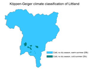
Climate

Köppen climate classification of Littland
Political geography
Historical regions
Resources and land use
- Natural resources: coal, copper, iron, natural gas, limestone, timber, arable land
- Land use:
- Forests and woodlands:
- Irrigated land:
Cities
| Rank | Subdivision | Pop. | |||||||
|---|---|---|---|---|---|---|---|---|---|
 Kaslund  Aalhavn |
1 | Kaslund | Capital Region | 2,525,000 |  Klintrup  Nebel | ||||
| 2 | Aalhavn | x | 1,047,920 | ||||||
| 3 | Klintrup | x | 972,929 | ||||||
| 4 | Nebel | Ruvian Autonomy | 727,871 | ||||||
| 5 | Halling | x | 583,444 | ||||||
| 6 | Kehlborg | x | 546,859 | ||||||
| 7 | Aadal | x | 481,296 | ||||||
| 8 | Leens | Ruvian Autonomy | 461,287 | ||||||
| 9 | [[]] | x | 416,988 | ||||||
| 10 | [[]] | x | 400,990 | ||||||
Articles about Littland | |||
|---|---|---|---|
| History |  | ||
| Geography | |||
| Politics | |||
| Economy | |||
| Society |
| ||
82 related articles • Part of Eurth Universe lore | |||
| History | |||||||||
|---|---|---|---|---|---|---|---|---|---|
| Continents & 132 Countries | |||||||||
| Geography |
| ||||||||
| Organisations |
| ||||||||
| Politics | |||||||||
| Law | |||||||||
| Military | |||||||||
| Economics | |||||||||
| Culture | |||||||||
| Sports | |||||||||