Geography of Littland
 | |
| Continent | Argis |
|---|---|
| Region | Central Argis |
| Area | |
| • Total | 198,000 km2 (76,000 sq mi) |
| Coastline | 1,836 km (1,141 mi) |
| Borders | 4,296 km (2,669 mi) |
| Highest point | Sol Mountain, 2,026 m (6,646 ft) |
| Lowest point | Nørrehuse, 3.8 m (12.4 ft) |
| Longest river | Arup River, 940.4 km (584.3 mi) |
| Climate | Temperate climate |
| Terrain | Lowlands, heathland, hills, mountains, forests |
| Natural resources | coal, copper, iron, natural gas, limestone, timber, arable land |
Topography
Land use
Biodiversity
Climate
Littland has a temperate climate. The southern mountain ranges are dominated by a climate climate area, the central and northern part of Littland experience a temperate climate year-round. Warm summers and chilly winters are characteristic of the Littish climate. The warmest part of Littland is the Aalhavn region while the coldest is the Malskland due to its elevation. Due to climate change, winters are becoming dryer and snow is rarer and rarer in the northern part of the country. Many plants and flora call Littland home and grow naturally. The most wide-spread type of tree in Littland are conifers such as spruce and pine.
| Climate data for Littland | |||||||||||||
|---|---|---|---|---|---|---|---|---|---|---|---|---|---|
| Month | Jan | Feb | Mar | Apr | May | Jun | Jul | Aug | Sep | Oct | Nov | Dec | Year |
| Average high °C (°F) | −0.9 (30.4) |
−1.1 (30.0) |
2.7 (36.9) |
9.5 (49.1) |
15.6 (60.1) |
19.4 (66.9) |
22.4 (72.3) |
21.3 (70.3) |
16.2 (61.2) |
9.6 (49.3) |
4.1 (39.4) |
1.0 (33.8) |
10.0 (50.0) |
| Average low °C (°F) | −5.6 (21.9) |
−6.5 (20.3) |
−3.9 (25.0) |
0.9 (33.6) |
5.6 (42.1) |
10.2 (50.4) |
13.2 (55.8) |
12.5 (54.5) |
8.6 (47.5) |
3.9 (39.0) |
0.0 (32.0) |
−3.1 (26.4) |
3.0 (37.4) |
| Average precipitation mm (inches) | 49 (1.9) |
39 (1.5) |
35 (1.4) |
34 (1.3) |
42 (1.7) |
70 (2.8) |
67 (2.6) |
81 (3.2) |
58 (2.3) |
72 (2.8) |
61 (2.4) |
53 (2.1) |
661 (26) |
| Source: Littisk Meteorologisk Institut | |||||||||||||
Political geography
Regions
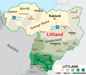
Historically Littland has been divided into many regions, culturally, politically, linguistically and economically. While these regions no longer exist de jure, they are still identifiable in the modern Littland.
- Ravvig, the area between Aalhavn and Klinstrup bordering the Amber Lake
- Snaremose, used to describe the area around the source of the Arup River, now mostly farmland
- Kehlet, old name for the Malskland, seen as a slur towards Malsks (known as "Kehlere"). Was primarily used following the 6 Year War
Some regions still in use today, in the form of counties are Aadal, Tronmark and Sønderland.

