Kotowari
People's Republic of Kotowari கோட்டோவாரி மக்கள் குடியரசு Kōṭṭōvāri Makkaḷ Kuṭiyaracu (Ramil) | |
|---|---|
 Flag | |
 Map of Kotowari | |
| Capital | Kotowari City |
| Recognised national languages | Ramil Telugu |
| Recognised regional languages | Mahanan Orinese Cristinese |
| Religion | 79.8% Hinduism 14.2% Buddhism 2.3% Gaism 1.7% Sikhism 0.7% Islam 0.4% Jainism 0.23% Unaffiliated 0.65% Others |
| Area | |
• | 640,456.47 km2 (247,281.63 sq mi) |
| Population | |
• 2022 estimate | 52,860,000 |
• 2018 census | 52,423,203 |
This article is incomplete because it is pending further input from participants, or it is a work-in-progress by one author. Please comment on this article's talk page to share your input, comments and questions. Note: To contribute to this article, you may need to seek help from the author(s) of this page. |
Kotowari (Ramil: கோட்டோவரி or Kōṭṭōvari), officially the People's Republic of Kotowari is a country in Oriental Europa. Bounded by the Jasmine Sea to the north, the Rosario Sea to the west and the Menelessar Inner Sea to the south, it shares land borders with Tamurin to the south-east and Mahana to the south-west. It is also within the vicinity of San Ba across the Jasmine Sea.
(1st paragraph. Name. Location. Borders. Approx population and size. Capital city.)
(2nd paragraph. Political system. Short history in 1 sentence. Link with present in 1 sentence. Head of state.)
(3rd paragraph. Economy in 2 sentences. International relations in 1 sentence.)
Etymology
(WIP.)
Geography
(WIP. Landscape. Climate.)
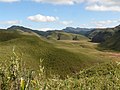
The $Name Valley has a temperate climate.

Caption
Caption
Caption


History
WIP.
- Look into Wari culture for similar climate.
- Consider relationship with the Pearl Road network, other Jasmine Sea countries, neighbouring Mahana / Tamurin.
- Joined the EOS in $year.
Politics
(WIP. Government. Political parties. Foreign relations. Military.)
Economy
(WIP. Eployment. Exports. Energy. Transport. Media. Currency.)
Demographics
(WIP. Ethnic groups. Language. Religion. Health. Education.)
Cultures
(WIP. Literature. Visual arts. Music. Cuisine. Sport.)
References
| History | |||||||||
|---|---|---|---|---|---|---|---|---|---|
| Continents & 135 Countries | |||||||||
| Geography |
| ||||||||
| Organisations |
| ||||||||
| Politics | |||||||||
| Law | |||||||||
| Military | |||||||||
| Economics | |||||||||
| Culture | |||||||||
| Sports | |||||||||