Mekabiri: Difference between revisions
m (→Geography: added climate map) |
m (updated intro and etymology) |
||
| Line 129: | Line 129: | ||
}} | }} | ||
'''{{PAGENAME}}''', officially known as the State of Mek'abiri, is a sovereign state in [[Europa (continent)|Europa]] on [[Eurth]]. | '''{{PAGENAME}}''', officially known as the State of Mekabiri and internally as Mek'abiri, is a sovereign state in Eastern [[Europa (continent)|Europa]] on [[Eurth]]. The country is bordered by [[Mahana]] to the north, [[Tamurin]] and [[Orioni]] in the east, and [[Miiros]] in the southwest. [[#Geography|Piri]] is the capital and Mi‘irabi is the largest city; other major towns include $ABC and $XYZ. Mekabiri is approximately {{convert|522,586|km2|sqmi|sp=us|abbr=on}} in size, without the territorial waters. The country is home to 9,149,522 inhabitants. | ||
Mekabiri is a bicameral presidential republic. The country's head of state is president [[#Politics|Rahaēli Sērafīmi]], supported by his Vice President Richard Haller. The territory that is now Mekabiri was first settled in prehistoric times. From the 14th century, it was a colony of [[Orioni]] until 1955 1822 the country gained its [[#History|independence]] as a fragile republic. Culturally, Mekabiri is still considered part of the [[Orinese]] diaspora. | |||
The country's wealth comes largely from the industrial and tourism sectors, with limited contributions from fishing and services. International cooperation with Orioni represents a large share of the country's domestic product. Mekabiri is part of several international and intergovernmental institutions, including the [[Assembled Nations]] and [[Entente of Oriental States]]. | |||
==Etymology== | ==Etymology== | ||
The name of Mekabiri is an {{wp|exonym}}, originating as the [[Oharic]] word ''Mek’abiri'' (መቃብር, "grave"), and is a reference to the relative position of where the Sun sets or "goes to die" when viewed from [[Orioni]]. During the [[#Colonial period|colonial period]] (1349-1822) the country was called | The name of Mekabiri is an {{wp|exonym}}, originating as the [[Oharic]] word ''Mek’abiri'' (መቃብር, "grave"), and is a reference to the relative position of where the Sun sets or "goes to die" when viewed from [[Orioni]]. During the [[#Colonial period|colonial period]] (1349-1822) the country was called Birlini. Other names have also been used, for example ''Mi'irabi'' ("west"), a term which applies to both Mekabiri and neighbouring [[Miiros]]. The name ''Merikebi'' ("ship" or "vessel") is a frequent misspelling, a reference to the many ships that once sailed back and forth between Mekabiri and Orioni. Late [[Aroma]]n historical sources have come to associate Mekabiri's hot and unforgiving climate with the ''{{wp|macabre}}'', a place that "having the quality of having a grim or ghastly atmosphere".{{citation needed}} | ||
==Geography== | ==Geography== | ||
Revision as of 10:42, 17 January 2022
State of Mekabiri | |
|---|---|
| Motto: Somnium vita est Life is a dream | |
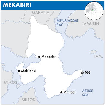
 Map of Mekabiri | |
| Capital | Piri |
| Largest | Mi‘irabi |
| Official languages | Oharic |
| Recognised regional languages | Mahanan, Tosyrai |
| Government | Presidential Republic |
• President | Rahaēli Sērafīmi |
• Vice President | Richard Haller |
| Area | |
• | 522,586 km2 (201,772 sq mi) |
| Population | |
• 2022 estimate | 9,149,522[1] |
| Antipodes | Bexshaw, Eulycea, Oyussa |
| Driving side | right |
| Internet TLD | .me |
Mekabiri, officially known as the State of Mekabiri and internally as Mek'abiri, is a sovereign state in Eastern Europa on Eurth. The country is bordered by Mahana to the north, Tamurin and Orioni in the east, and Miiros in the southwest. Piri is the capital and Mi‘irabi is the largest city; other major towns include $ABC and $XYZ. Mekabiri is approximately 522,586 km2 (201,772 sq mi) in size, without the territorial waters. The country is home to 9,149,522 inhabitants.
Mekabiri is a bicameral presidential republic. The country's head of state is president Rahaēli Sērafīmi, supported by his Vice President Richard Haller. The territory that is now Mekabiri was first settled in prehistoric times. From the 14th century, it was a colony of Orioni until 1955 1822 the country gained its independence as a fragile republic. Culturally, Mekabiri is still considered part of the Orinese diaspora.
The country's wealth comes largely from the industrial and tourism sectors, with limited contributions from fishing and services. International cooperation with Orioni represents a large share of the country's domestic product. Mekabiri is part of several international and intergovernmental institutions, including the Assembled Nations and Entente of Oriental States.
Etymology
The name of Mekabiri is an exonym, originating as the Oharic word Mek’abiri (መቃብር, "grave"), and is a reference to the relative position of where the Sun sets or "goes to die" when viewed from Orioni. During the colonial period (1349-1822) the country was called Birlini. Other names have also been used, for example Mi'irabi ("west"), a term which applies to both Mekabiri and neighbouring Miiros. The name Merikebi ("ship" or "vessel") is a frequent misspelling, a reference to the many ships that once sailed back and forth between Mekabiri and Orioni. Late Aroman historical sources have come to associate Mekabiri's hot and unforgiving climate with the macabre, a place that "having the quality of having a grim or ghastly atmosphere".[citation needed]
Geography
WIP
- Landscape. Mekabiri is characterized by its mountains and dry climate, and its lack of major rivers. There are many small forests along the southern coast, whose trees grow big and strong because of the righ soil.[2]
- Climate
- Southern coast is habitable. Rest is desert.
- Capital at an estuary, in a well-defensible position. Natural harbor? Ancient dock of the Pearl Road?
- Keep Emakera as a border province. Influence from nearby authoritarian Mantella, who attempted to detach this territory from Mekabiri by emphasising the north-south differences and exploit cultural differences.
History
Pre-colonial era
- Early population comes from Azania and Amutia in the west. Land used to be much greener, but after the last ice age ended the climate became warmer with increased desertification.
- Prehistory: This leads to more diversity in the cultures: fishermen along the coast, heders in the highlands, nomads in the desert.
- 1000-0 BCE: Small pockets of agriculture, mostly subsistence farming.
- 0-500s CE: Tie into the Pearl Road. Crossroads for many other historic nations.
- 500-1000s: Borderland against the Sacred Aroman Realm.
Colonial period
- 1000-1500s: Tie into the Orinese colonial expansion. First forts along the coast. Later on more defensive lines inland. Mostly extraction economy.
- 1349-1822: Official colonial period of Birlini.
- Area gives Orioni control of the Menelassar Sea.
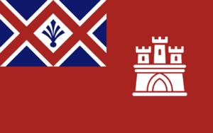
- Colonial flag with a tower refers to the typical colonial-era forts along the coast. These could also be further inland. From a strategic point of view, there need to be at least two "choke points" along each side of the northern mountain range.
Independence
20th and 21st centuries
Politics
WIP
- Government.
- Separation of Powers: Legislative, Judiciary, and Executive
- Federalist system. 7 provinces and the Capital district.
- Bicameral legistlative system. The Càmara dos Deputados has 100 members, directly elected by the people, which makes law projects and propositions. The Càmara dos Senadores has 100 members, also elected by the people, which vote for or against the law projects made by the deputados.[3]
- Political parties.
- Foreign relations. Mekabiri is a member of the Assembled Nations and the Entente of Oriental States. Previously a member of the Europan Commercial Alliance.
- Military.
Economy
WIP
- Looking into the economy of RL Morocco, which is also a mostly coastal country with a dry hinterland.
- Exports.
- Currency. Wanna use the Orinese Phi, but might also go with Miiros just to snub the old coloniser.
- Employment. Might opt for Moroccan unemployment numbers, so as no to overpower any neighbours.
- Energy.
- Transport.
- Media.
Demographics
WIP
Mekabiri's population consists mostly of Orinese settlers and native peoples, the Emakeran being the most known of them. Since intermarriage between the settlers and the natives is very usual in Emakera, most of the people have mixed ancestry in some degree. Everyone born in the country is treated as emakeran, independent of heritage, and racism is a unbailable crime.[2]
- Ethnic groups. All people born in Emakera are considered to be ethnically Emakeran. Major Minorities: Alentejanos , Algarvios and Alfacinhas
- Language. Portuguese is the only official language of Emakera, and there are few regional variances. It is virtually the only language used in schools, newspapers, radio and TV, and for all business and administrative purposes. The language spoken in Brazil (and thus, in Emakera too) is slightly different from that spoken in Portugal and other Portuguese-speaking countries. Brazilian Portuguese is more archaic than European Portuguese, and has some phonological and orthographic differences, although mutual comprehension is not affected.[2]
- Religion. Mekabiri is an secular state. Evangelical Protestant (45%), Roman Catholic (30%), Orinese faiths (15%), Islam (5%), Other Faiths (3%), No religion (2%).[3]
- Health.
Education.
- Mixture of Pirilao and Emakera. Adopt culture from both. Previously these two separate countries. But now they are a mixture of both. This forced colocation purposely undermines Mekabiri's internal stability. This is comparable to how Iraq was constructed out of 3 large, competing groups.
- Continue to build a shared lore with Mahana.
Cultures
WIP
- Literature.
- Visual arts.
- Music.
- Cuisine.
- Sport.
References
- ↑ OOC. The population number is the calculated average of Emakera and Pirilao.
- ↑ 2.0 2.1 2.2 NSwiki: Emakera (15 January 2006)
- ↑ 3.0 3.1 The Federative Popular Republic of Emakera (13 January 2006)


