Jutpandi: Difference between revisions
No edit summary |
No edit summary |
||
| (4 intermediate revisions by the same user not shown) | |||
| Line 11: | Line 11: | ||
| perrow = 1/2/2/2 | | perrow = 1/2/2/2 | ||
| image1 = 2015-03-08_Swayambhunath,_Katmandu,_Nepal.jpg | | image1 = 2015-03-08_Swayambhunath,_Katmandu,_Nepal.jpg | ||
| image2 = | | image2 = Kathmandu_Durbar_Market_2007.jpg | ||
| image3 = Laxmi_Vilas_Palace,_Baroda.jpg | | image3 = Laxmi_Vilas_Palace,_Baroda.jpg | ||
| image4 = Swayambhunath_2018.jpg | | image4 = Swayambhunath_2018.jpg | ||
| Line 18: | Line 18: | ||
| image7 = Evening_view_of_the_mountain_range_from_Patan,_Lalitpur.jpg | | image7 = Evening_view_of_the_mountain_range_from_Patan,_Lalitpur.jpg | ||
| color = white | | color = white | ||
| footer = '''From top, left to right''': Panorama of the Jutpandi Skyline, Jutpandi | | footer = '''From top, left to right''': Panorama of the Jutpandi Skyline, Jutpandi Bhirkot Square; [[Jutpandi Royal Palace]]; Bhunath; Resuri District; Mahanan Water Garden; View of the [[Samripe Mountain Range|Outer Samripes]] from Jutpandi | ||
}} | }} | ||
| image_alt = | | image_alt = | ||
| Line 63: | Line 63: | ||
| leader_party = | | leader_party = | ||
| leader_title = | | leader_title = | ||
| leader_name = | | leader_name = | ||
| leader_title1 = | | leader_title1 = | ||
| leader_name1 = | | leader_name1 = | ||
| Line 133: | Line 133: | ||
During the 16th century national reforms lead to a further economic growth period in the city, the same period of time that a lot of modern Mahanan architectural techniques began to appear with woodworking and ironworks becoming more advanced. The first foreign record of the city was by [[Feldora]]n explorer Joao Cabral in 1665 who passed through the valley and was welcomed by the king at the time on their way to [[Kotowari]] from the Byzantine Bay. | During the 16th century national reforms lead to a further economic growth period in the city, the same period of time that a lot of modern Mahanan architectural techniques began to appear with woodworking and ironworks becoming more advanced. The first foreign record of the city was by [[Feldora]]n explorer Joao Cabral in 1665 who passed through the valley and was welcomed by the king at the time on their way to [[Kotowari]] from the Byzantine Bay. | ||
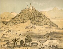
[[File:Kathmandu_durbar_square.jpg|250px|thumb|right|Jutpandi Bhirkot Square, 1843.]] | |||
In the 1750s almost a third of the cities population was wiped out in a famine which occurred due to a change in seasonal temperature following a large-scale earthquake. During the 1770s, Mahana had a period of heavy religious instability, mostly due to conflict between the [[Gaism|Gai]] and {{wp|Hindu}} populations. During this period the city experienced attacks on religious buildings, including the burning of a famous Stupa. At the end of 1798, the [[Jutpandi March]] took place which saw protests across the city inspired by [[Saroja Suwal]]'s actions in [[Veydu]]. This was one of the final events which lead to a gradual desegregation of religious groups in Mahana. | In the 1750s almost a third of the cities population was wiped out in a famine which occurred due to a change in seasonal temperature following a large-scale earthquake. During the 1770s, Mahana had a period of heavy religious instability, mostly due to conflict between the [[Gaism|Gai]] and {{wp|Hindu}} populations. During this period the city experienced attacks on religious buildings, including the burning of a famous Stupa. At the end of 1798, the [[Jutpandi March]] took place which saw protests across the city inspired by [[Saroja Suwal]]'s actions in [[Veydu]]. This was one of the final events which lead to a gradual desegregation of religious groups in Mahana. | ||
| Line 141: | Line 141: | ||
The city began to struggle yet again under the harsh monarcho rule of [[King Raju II]], aligning with the rest of the economic crisis in Mahana during the 1960s. In 1970 press was controlled by the monarchy and by 1971 press had been censored fully. Following this, in 1973 mass protests were held in the city as well as other major cities in the country to protest the totalitarian regime under the [[Misra dynasty|Misrans]]. In Jutpandi this was met with police resistance, ending in the deaths of an estimated 40 people in total, including 3 officers. Following the abdication of [[King Raju II]], the new king [[King Raju III|Raju III]] was the first monarch to not be corinated in the city, instead being coronated in [[Ghobari]]. | The city began to struggle yet again under the harsh monarcho rule of [[King Raju II]], aligning with the rest of the economic crisis in Mahana during the 1960s. In 1970 press was controlled by the monarchy and by 1971 press had been censored fully. Following this, in 1973 mass protests were held in the city as well as other major cities in the country to protest the totalitarian regime under the [[Misra dynasty|Misrans]]. In Jutpandi this was met with police resistance, ending in the deaths of an estimated 40 people in total, including 3 officers. Following the abdication of [[King Raju II]], the new king [[King Raju III|Raju III]] was the first monarch to not be corinated in the city, instead being coronated in [[Ghobari]]. | ||
During the [[Mahanan Civil War]] the city saw little fighting, with part of the [[Assembled Nations]] [[Assembled Nations Mission in Mahana|Mission in Mahana]] being tasked in protecting civilian areas from fighting. Despite this, parts of the city were damaged by the war, including parts of the Jutpandi Royal Palace and the Stupa. | |||
==Geography== | ==Geography== | ||
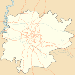
[[File:Jutpandi City Map.png|250px|thumb| | [[File:Jutpandi City Map.png|250px|thumb|left|A map of the roads of the city.]] | ||
Jutpandi is located on the foothills of the [[Samripe Mountain Range]]. | |||
==Demographics== | ==Demographics== | ||
==Government== | ==Government== | ||
The Jutpandi City Council (Juṭapāṇḍī Nagara Pariṣad) is the chief agency for the administration of Jutpandi. The municipality of Jutpandi was upgraded into a metripolitan city in 2001. | |||
The metripolitan city of Jutpandi is divided into 5 sections; the Inner City, East Jutpandi, North Jutpandi, South Jutpandi and West Jutpandi. The city is further divided into 35 administrative sectors. | |||
==International relations and organisations== | ==International relations and organisations== | ||
===Twin towns - Sister cities=== | ===Twin towns - Sister cities=== | ||
| Line 153: | Line 159: | ||
*{{flagicon|Aurivizh}} [[Alivezh]], Aurivizh | *{{flagicon|Aurivizh}} [[Alivezh]], Aurivizh | ||
*{{flagicon|Orioni}} [[O'polis]], Orioni | *{{flagicon|Orioni}} [[O'polis]], Orioni | ||
===Proposed Sister Cities=== | |||
*{{flagicon|Tamurin}} [[Alaghon]], Tamurin | |||
==References== | ==References== | ||
{{reflist}} | {{reflist}} | ||
[[Category:Mahana]] | [[Category:Mahana]] | ||
{{Eurth}} | {{Eurth}} | ||
Latest revision as of 10:52, 30 June 2023
Jutpandi
जुटपान्डी | |
|---|---|
City | |
From top, left to right: Panorama of the Jutpandi Skyline, Jutpandi Bhirkot Square; Jutpandi Royal Palace; Bhunath; Resuri District; Mahanan Water Garden; View of the Outer Samripes from Jutpandi | |
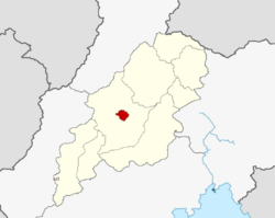
 Map of Jutpandi within the Nuragara Province. | |
| Population (2012) | |
| • Total | 1,674,394 |
| • Metro | 3.1 million |
| • Capital City | 856,494 |
| Website | www.visitjutpandi.ma |
Jutpandi (,Jot-Pan-Dee (English Pronounciation), Mahanan: जुटपान्डी), Officially the Jutpandi Metripolitan City, is the capital and most populous city of Mahana as well as the Nuragara Province with 1,600,000 people living in 350,000 houses as of 2021. The city is incredibly important as it is not only the home to the nations parliament and government but also the Gayin (leader of the Gaism religion) in the Karayanhiti Palace. It is located on the footsteps of the Samripes, with only two major access points through the M49 and M62 motorways from Ghobari and Battagara respectfully.
The city is one of the oldest continuously inhabited places in the world, founded in 10th century CE, however existing as Vaddkewatta since 433 BC. The city has historically been the capital city of great empires and nations such as the Aayan Empire, the Nadal Empire and, most recently, Mahana. The city was built in the historic region of Bāhirī, home historically to the Gaimreti people group who founded the city. Jutpandi became important as it was the only cosmopolitan urban civilisation in the Samripe foothills. As the historic capital of the Kingdom of Mahana, the city hosts great gardens, palaces and mansions which display the finest of Mahanan aristocracy. As well as this in more recent times the city has been one of two headquarters[1] of the Oriental Association for Regional Cooperation (OARC). Today, the city holds the seat of government for Mahana as well as the leader of the Gai religion.
For several centuries Jutpandi has acted as the centre for Mahana's art, literature, history, culture and economy. It contains a multi-ethnic and religious population, with followers of Hinduism, Gaism and Buddhism existing in large percentages within the city. Religious and cultural festivities make up a big part of the cities culture as well as the lives of the residents. Similarly to the rest of the country, Jutpandi's economy relies on a lot of the tourism that comes into the city.
Etymology
"Jutpandi" originates from the two names of the ancient halves of Vaddkewatta, Jutihit and Panupatinagar. Upon the rebuilding of the new city it became known as "Juptondee" representing the unification of the city.
History
The city of Vaddkewatta was founded by the Urduk people, an early predecessor to the Gaimreti people group of modern Mahana, in 433 BC. The old Urduk city was built on top of a hill, with the ancient Bhunath being built on top crowning the city. At this time the city was split in half between two halves, one called Jutihit and the other Panupatinagar. Between the 1st and 3rd century AD, the city prospered and grew due to the growing regional popularity of Gaism, which was headquartered in the city. This lead to it eventually dominating many of the city-states and other towns and municipalities around it. Due to this it became the capital of the Aayan Empire prior to it's collapse.
During the war between the Kurula Dynasty, the Nadal Empire and the Ekaviri Empire the city was sacked by the invading Ekaviri Empire while under the control of the Nadal Empire. Despite this, the city was rebuilt as "Jutpanupati" following initial Mahanan unification in 1100. The city became the capital of Mahana for the first time when King Raj I located his monarchy and advisory in the city, building the earliest version of the Jutpandi Royal Palace near the current location of the building.
During the 16th century national reforms lead to a further economic growth period in the city, the same period of time that a lot of modern Mahanan architectural techniques began to appear with woodworking and ironworks becoming more advanced. The first foreign record of the city was by Feldoran explorer Joao Cabral in 1665 who passed through the valley and was welcomed by the king at the time on their way to Kotowari from the Byzantine Bay.
In the 1750s almost a third of the cities population was wiped out in a famine which occurred due to a change in seasonal temperature following a large-scale earthquake. During the 1770s, Mahana had a period of heavy religious instability, mostly due to conflict between the Gai and Hindu populations. During this period the city experienced attacks on religious buildings, including the burning of a famous Stupa. At the end of 1798, the Jutpandi March took place which saw protests across the city inspired by Saroja Suwal's actions in Veydu. This was one of the final events which lead to a gradual desegregation of religious groups in Mahana.
The city was minorly impacted during the late 1700s and 1800s by Mahanan war with Mekabiri and later the conflict with Namdatka which lead to a small period of economic crisis.
In the early 20th century Mahana became hugely effected by the Byzantine Flu which had arrived from further south and began to spread quickly across the nation. The flu reached the capital city by 1917, becoming a huge issue very quickly. Due to Jutpandi's Mahato Architectural Period, much of the city could be classified as slums as populations were closed tightly together in large amounts through urban areas of the city. This caused the flu to spread rapidly and uncontrollably, with hospitals becoming over congested quickly due to the influx of sick patients. This made the casualty rates very high, with an estimated 100,000 in the city alone. Despite this, the flu was combatted and completely eliminated by around 1920.
The city began to struggle yet again under the harsh monarcho rule of King Raju II, aligning with the rest of the economic crisis in Mahana during the 1960s. In 1970 press was controlled by the monarchy and by 1971 press had been censored fully. Following this, in 1973 mass protests were held in the city as well as other major cities in the country to protest the totalitarian regime under the Misrans. In Jutpandi this was met with police resistance, ending in the deaths of an estimated 40 people in total, including 3 officers. Following the abdication of King Raju II, the new king Raju III was the first monarch to not be corinated in the city, instead being coronated in Ghobari.
During the Mahanan Civil War the city saw little fighting, with part of the Assembled Nations Mission in Mahana being tasked in protecting civilian areas from fighting. Despite this, parts of the city were damaged by the war, including parts of the Jutpandi Royal Palace and the Stupa.
Geography
Jutpandi is located on the foothills of the Samripe Mountain Range.
Demographics
Government
The Jutpandi City Council (Juṭapāṇḍī Nagara Pariṣad) is the chief agency for the administration of Jutpandi. The municipality of Jutpandi was upgraded into a metripolitan city in 2001.
The metripolitan city of Jutpandi is divided into 5 sections; the Inner City, East Jutpandi, North Jutpandi, South Jutpandi and West Jutpandi. The city is further divided into 35 administrative sectors.
International relations and organisations
Twin towns - Sister cities
Proposed Sister Cities
 Alaghon, Tamurin
References
- ↑ "Kotowari City and Jutpandi, Mahana, are the two headquarters of the OARC" (JPG)"


