Pearl Road: Difference between revisions
mNo edit summary |
m (better map) |
||
| Line 1: | Line 1: | ||
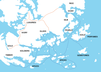
[[File:Map of the Pearl Road. | [[File:Map of the Pearl Road.png|350px|thumb|Network of the Pearl Road]] | ||
The '''Pearl Road''' or Pearl Route refer to the ancient maritime {{wp|trade route}} that connected several important parts of southern [[Europa (continent)|Europa]] on [[Eurth]]. | The '''Pearl Road''' or Pearl Route refer to the ancient maritime {{wp|trade route}} that connected several important parts of southern [[Europa (continent)|Europa]] on [[Eurth]]. | ||
Revision as of 12:54, 2 February 2021
The Pearl Road or Pearl Route refer to the ancient maritime trade route that connected several important parts of southern Europa on Eurth.
Evolution
The Pearl Road was established in the 2nd Century. Evidence of these movements can be seen in shipwrecks recovered in the Rivdon Bay and Rosario Sea. The route overlapped with local Miirosi maritime trade, Paraia Sea trade, Hakenian naval trade network. The Pearly gates was an informal name for the strait between Tamurin and Orioni, a term later repurposed by some early Christians. By the 9th century Ayubi was one of the final links in the Pearl Road.
Routes
The trade route included crossing several bodies of waters skirting the Oriental Ocean and Adlantic Ocean, but not yet into the open ocean.
From east to west, this maritime trade route measured approximately 18,839 kilometres (10,172 nmi) and connected:
- Oriental states such as Jaihu and Orioni,
- the Meteorolan archipelago,
- Memopotamian peninsula,
- all the way around Azania and
- finally Occidental Aroma.
