Mekabiri
State of Mekabiri | |
|---|---|
 Map of Mekabiri | |
| Capital | Piri |
| Largest | Mi‘irabi |
| Official languages | Oharic |
| Recognised regional languages | Mahanan, Tosyrai |
| Government | Presidential Republic |
• President | Rahaēli Sērafīmi |
| Area | |
• | 522,586 km2 (201,772 sq mi) |
| Population | |
• 2022 estimate | 9,149,522[1] |
| Antipodes | Bexshaw, Eulycea, Oyussa |
| Driving side | right |
| Internet TLD | .me |
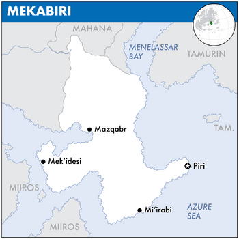
Mekabiri, officially known as the State of Mek'abiri, is a sovereign state in Europa on Eurth. It is bordered by Mahana to the north, Tamurin and Orioni in the east, and Miiros in the southwest.
(1st paragraph. Name. Location. Borders. Approx population and size. Capital city.)
(2nd paragraph. Political system. Short history in 1 sentence. Link with present in 1 sentence. Head of state.)
(3rd paragraph. Economy in 2 sentences. International relations in 1 sentence.)
Etymology
The name of Mekabiri is an exonym, originating as the Oharic word Mek’abiri (መቃብር, "grave"), and is a reference to the relative position of where the Sun sets or "goes to die" when viewed from Orioni. During the colonial period (1349-1822) the country was called Birlini.
WIP. Vlakbij ook Mi'irabi ("west") als uitleg voor Miiros. Zie ook Mishiti ("evening"), Meshe ("dusk"), Moti ("death", ~zonsondergang). Doet ook denken aan Mecca en macabre. Ship = merikebi (Oharic).
Geography
This article is incomplete because it is pending further input from participants, or it is a work-in-progress by one author. Please comment on this article's talk page to share your input, comments and questions. Note: To contribute to this article, you may need to seek help from the author(s) of this page. |
WIP
- Landscape
- Climate
- Zuidelijke kust is bewoonbaar. Rest is woestijn.
- Hoofdstad aan riviermonding, op een goed verdedigbare postitie. Natuurlijke haven? Oeroude aanlegplaats van Pearl Road?
- Emakera als grensprovincie. Invloed van autoritaire Mantella. Poging om gebied los te weken van MEkabiri. Noord-zuid verschillen benadrukken. Culture verschillen uitbuiten.
History
Pre-colonial era
- Early population comes from Azania and Amutia in the west. Land used to be much greener, but after the last ice age ended the climate became warmer with increased desertification.
- Prehistory: This leads to more diversity in the cultures: fishermen along the coast, heders in the highlands, nomads in the desert.
- 1000-0 BCE: Small pockets of agriculture, mostly subsistence farming.
- 0-500s CE: Tie into the Pearl Road. Crossroads for many other historic nations.
- 500-1000s: Borderland against the Sacred Aroman Realm.
Colonial period
- 1000-1500s: Tie into the Orinese colonial expansion. First forts along the coast. Later on more defensive lines inland. Mostly extraction economy.
- 1349-1822: Official colonial period of Birlini.
- Gebied geeft Orioni controle over de Menelassar Sea.
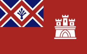
- Vlag met toren verwijst naar forten langs de kust, ofwel verder in het binnenland. Twee "chokepoints" langsheen het gebergte.
Independence
20th and 21st centuries
Politics
WIP
- Government
- Political parties.
- Foreign relations. Mekabiri is a member of the Assembled Nations and the Entente of Oriental States. Previously a member of the Europan Commercial Alliance.
- Military.
Economy
(WIP
- Looking into the economy of RL Morocco, which is also a mostly coastal country with a dry hinterland.
- Exports.
- Currency. Wanna use the Orinese Phi, but might also go with Miiros just to snub the old coloniser.
- Employment. Might opt for Moroccan unemployment numbers, so as no to overpower any neighbours.
- Energy.
- Transport.
- Media.
Demographics
(WIP. Ethnic groups. Language. Religion: Health. Education.)
- Mengeling van Pirilao en Emakera. Cultuur overnemen van beide. Waren voordien twee landen, nu een mengeling van beide om onafhankelijkheid te ondermijnen.
- Gedeelde lore opbouwen met Mahana.
Cultures
(WIP. Literature. Visual arts. Music. Cuisine. Sport.)


