Chulo Empire: Difference between revisions
m (spelling) |
m (→Late period: +legacy) |
||
| (8 intermediate revisions by 2 users not shown) | |||
| Line 1: | Line 1: | ||
{{Infobox country | {{Infobox country | ||
| conventional_long_name | | conventional_long_name = Chulo Empire | ||
| native_name | | native_name = | ||
| common_name | | common_name = Chulo Empire | ||
| status | | status = Empire | ||
| life_span | | life_span = 5th century BCE{{snd}}2nd century CE | ||
| image_flag | | image_flag = | ||
| flag_border | | flag_border = | ||
| alt_flag = | | alt_flag = | ||
| | | flag_type = | ||
| | | image_coat = [[File:Flag of Nunatsiavut.svg|222px]] | ||
| coa_size | | coa_size = | ||
| alt_coat | | alt_coat = | ||
| symbol_type | | symbol_type = Common Chulese symbol of balancing rocks. | ||
| image_map | | image_map = Map of the Chulo Empire.png | ||
| image_map_caption | | image_map_caption = Map of the Chulo Empire. | ||
| capital | | capital = [[#Geography|Pa'pi]] | ||
| common_languages | | common_languages = | ||
| religion | | religion = | ||
| demonym | | demonym = Chulese | ||
| government_type | | government_type = Thalassocratic monarchy | ||
| legislature | | legislature = | ||
| era | | era = | ||
| area | | area = | ||
|population_estimate = 60,000-75,000 | | population_estimate = 60,000-75,000 | ||
|population_estimate_rank = | | population_estimate_rank = | ||
|population_estimate_year = | | population_estimate_year = | ||
| currency | | currency = | ||
| footnotes | | footnotes = | ||
| today | | today = {{plainlist}} | ||
* {{flag|Apuni}} | |||
* {{flag|Ayubi}} | * {{flag|Ayubi}} | ||
* {{flag|Bainbridge Islands}} | * {{flag|Bainbridge Islands}} | ||
* {{flag|Damak Var}} | * {{flag|Damak Var}} | ||
* {{flag|Miiros}} ( | * {{flag|Mevraq}} | ||
* {{flag|Miiros}} (outer islands) | |||
* {{flag|Niederoestereich}} | * {{flag|Niederoestereich}} | ||
* {{flag|Red Iberos}} (outer islands) | |||
* {{flag|Safiloa}} | |||
* {{flag|San Giorgio}} | |||
* {{flag|San Jorge}} | |||
}} | }} | ||
The '''Chulo Empire''' was an ancient thalassocratic state located in the Meteorolan archipelago of southern [[Europa (continent)|Europa]] on [[Eurth]]. The earliest datable references to the Chulo are inscriptions from the 5th century BCE. According to historic tradition, the Chulo nation comprised the region that includes the modern-day countries of [[Ayubi]], [[Bainbridge Islands]] and [[Damak Var]]. The Chulese excelled in maritime trade, extending their influence overseas to [[Azania]]n and [[Orient]]al Europa. | The '''Chulo Empire''' was an ancient {{wp|Thalassocracy|thalassocratic}} state located in the Meteorolan archipelago of southern [[Europa (continent)|Europa]] on [[Eurth]]. The earliest datable references to the Chulo are inscriptions from the 5th century BCE. According to historic tradition, the Chulo nation comprised the region that includes the modern-day countries of [[Ayubi]], [[Bainbridge Islands]] and [[Damak Var]]. The Chulese excelled in maritime trade, extending their influence overseas to [[Azania]]n and [[Orient]]al Europa. Early inscriptions found in nearby [[Memopotamia]] show the Chulo was referred to as Al-Cahuete. | ||
==Geography== | == Geography == | ||
The Chulese archipelago was located off the southern coast of [[Europa (continent)|Europa]], where they inhabited several large and small islands. The capital city of Pa'pi was located on the largest island, in what is now [[Damak Var]]. Its deepwater port made it an excellent way to export the metals and minerals mined on the island's interior. The national economy largely rested on trade between the various islands, though there was also some trade with the Europan mainland. Other cities were scattered among the islands, notably Puʻupuʻu, Lalo Ka‘puaʻa, Kuhi Dew, Puʻuwai Lewa, | |||
The Chulese archipelago was located off the southern coast of [[Europa (continent)|Europa]], where they inhabited several large and small islands. The capital city of Pa'pi was located on the largest island, in what is now [[Damak Var]]. Its deepwater port made it an excellent way to export the metals and minerals mined on the island's interior. The national economy largely rested on trade between the various islands, though there was also some trade with the Europan mainland. Other cities were scattered among the islands, notably Puʻupuʻu, Lalo Ka‘puaʻa, Kuhi Dew, Puʻuwai Lewa, Laau Makani and Kambanu in [[Safiloa]].<ref name="forum-factbook">[https://www.europans.com/topic/4656-the-allied-states-of-meteorola/ The Allied States of Meteorola] (23 September 2005)</ref> | |||
== History == | |||
=== Early period === | |||
{{wip}} | {{wip}} | ||
[[File:TO-Haamonga A Maui.JPG|200px|thumb|right|Stone {{wp|trilithon}} of {{wp|Haʻamonga ʻa Maui|Makani Pāhili}} marked meeting places for the Council of the Isles.]] | [[File:TO-Haamonga A Maui.JPG|200px|thumb|right|Stone {{wp|trilithon}} of {{wp|Haʻamonga ʻa Maui|Makani Pāhili}} marked meeting places for the Council of the Isles.]] | ||
First discovered by the mainlanders from nearby [[Memopotamia]] in [[Azania]]. Long before they knew of each other, the people of the isolated islands, very much believed in nature, and most of all | (WIP. Mythical figure of Hurricane Eric. Translate the etymology for Eric into Hawaiian.<ref>https://translate.google.com/?sl=en&tl=haw&text=one%0Aalone%0Aunique%0Aeverlasting%0Aeternity&op=translate</ref> Going even further back in time, we can reference our own version of the mythical {{wp|Laputa}}/{{wp|Lapita culture}}, tied into the first Azanian migrations.) | ||
The Chulese had the ability to navigate the open seas and were the first peoples to regularly send fishing boats along the coastlines. They were the first true masters of the sea in human history. Or, more accurate: they were the first true masters of the sea in human history that we know of. A much earlier example of seamanship would be the [[Marenesia]]n expansion. This was a centuries-long process carried out by numerous groups. But these were not a united, centralised civilisation like the Chulese.<ref>[https://www.youtube.com/watch?v=t6cHnbYWk0E&t=131s Who were the Minoans?] by Epimetheus (21 December 2021)</ref> | |||
First discovered by the mainlanders from nearby [[Memopotamia]] in [[Azania]]. Long before they knew of each other, the people of the isolated islands, very much believed in nature, and most of all, the weather. The islands' discovery began a chain of events that led each island to learn from its neighbours. The understanding that they were no longer alone began a series of cultural exchanges that blended together and eventually made each island's people indistinguishable from another. | |||
The Chulese had an early form of representative democracy. Their 'parliament' or Council of the Isles met annually to discuss matters of importance, especially international relations and foreign trade. The Council was headed by a person called the 'Hurricane'. Individual islands could have their own laws and regulations. These could form coalitions within the Council, representing all different views of the people, from the east wind to the west wind.<ref name="forum-factbook"/> | The Chulese had an early form of representative democracy. Their 'parliament' or Council of the Isles met annually to discuss matters of importance, especially international relations and foreign trade. The Council was headed by a person called the 'Hurricane'. Individual islands could have their own laws and regulations. These could form coalitions within the Council, representing all different views of the people, from the east wind to the west wind.<ref name="forum-factbook"/> | ||
===High period=== | === High period === | ||
The multiple governments | The multiple governments recognised that the people of the Weathered Isles were not as technologically advanced as the mainlanders. Most nations turned to the military for research. This caused a slow build up of organised military practices. About 100 years after the Awakening, the first of a long series of wars began ravaging the islands. The mainland, unconcerned, did not become involved. Commerce instead was responsible for bringing technology to the Weathered Islands, mainly shipping building in the port cities.<ref name="forum-factbook"/> The Chulese effectively became Lords of the Sea. They formed a {{wp|thalassocracy}} (“sea power”) of naval supremacy based on either military or commercial senses. | ||
<gallery> | |||
F 2 070 182 Uk Uni grinding stone 1957 Myer's plantation, Samoa.jpg|Ancient Chulese grinding stones, excavated by the [[Imperial Orinese Navy|Orinese Navy]] divers off the coast of [[Niederoestereich]]. | |||
HouseOfTagaAfterYutu.jpg|Chulese structures were found as far west as the Nusantara Island Chain. | |||
</gallery> | |||
=== Late period === | |||
[[File:Maya ruins in Mexico 003.jpg|thumb|Ruins of abandoned Chulese city.]] | |||
(WIP. Lasted until 127 CE.) | (WIP. Lasted until 127 CE.) | ||
It was only 100 years ago that the people of the Weathered Isles rose up against the various Monarchs and | It was only 100 years ago that the people of the Weathered Isles rose up against the various Monarchs and created the Alliance. The first uprising took place in ‘The Eye of the Storm’. The revolt was led by our national hero and namesake, [[Penn Meteo]]. Within 10 years, the ‘Winds of Change’ (as the revolutions are collectively called) had reached all the islands. | ||
Penn Meteo was determined that there should never again be a war between the islands and tried to unite them. He died before his dream was achieved. Some countries, however, did unite, just not all. Tensions over fishing rights, as well as the memories of old wars, kept total unification at bay. Eventually, despite heavy negotiations, the Weathered Islands fragmented into several dozen separate island states.<ref name="forum-factbook"/> | Penn Meteo was determined that there should never again be a war between the islands and tried to unite them. He died before his dream was achieved. Some countries, however, did unite, just not all. Tensions over fishing rights, as well as the memories of old wars, kept total unification at bay. Eventually, despite heavy negotiations, the Weathered Islands fragmented into several dozen separate island states.<ref name="forum-factbook"/> | ||
==See also== | === Legacy === | ||
* [[Timeline of | |||
WIP. | |||
* Some cultural traditions remains. | |||
* Like the building styles. | |||
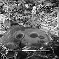
* And the !stone masks, cf. {{wp|Asaro Mudmen}}. | |||
<gallery> | |||
Asaro Mud Men (48885957917).jpg|Caption. | |||
Thiafamous 4318b.JPG|Caption. | |||
Asaro mudmen.jpg|Caption. | |||
Asaro Mud Man Kabiufa Papua New Guinea.jpg|Caption. | |||
Asaro Mud Men (48885783006).jpg|Caption. | |||
</gallery> | |||
== See also == | |||
* [[Timeline of Eurth]] | |||
* [[List of former countries on Eurth]] | * [[List of former countries on Eurth]] | ||
==References== | == References == | ||
{{reflist}} | {{reflist}} | ||
[[Category:History (Eurth)]] | |||
{{Eurth}} | {{Eurth}} | ||
Latest revision as of 14:55, 23 April 2024
Chulo Empire | |
|---|---|
| 5th century BCE – 2nd century CE | |
 Common Chulese symbol of balancing rocks.
| |
| Map of the Chulo Empire. Map of the Chulo Empire. | |
| Capital | Pa'pi |
| Demonym(s) | Chulese |
| Government | Thalassocratic monarchy |
| Population | |
• Estimate | 60,000-75,000 |
| Today part of |
|
The Chulo Empire was an ancient thalassocratic state located in the Meteorolan archipelago of southern Europa on Eurth. The earliest datable references to the Chulo are inscriptions from the 5th century BCE. According to historic tradition, the Chulo nation comprised the region that includes the modern-day countries of Ayubi, Bainbridge Islands and Damak Var. The Chulese excelled in maritime trade, extending their influence overseas to Azanian and Oriental Europa. Early inscriptions found in nearby Memopotamia show the Chulo was referred to as Al-Cahuete.
Geography
The Chulese archipelago was located off the southern coast of Europa, where they inhabited several large and small islands. The capital city of Pa'pi was located on the largest island, in what is now Damak Var. Its deepwater port made it an excellent way to export the metals and minerals mined on the island's interior. The national economy largely rested on trade between the various islands, though there was also some trade with the Europan mainland. Other cities were scattered among the islands, notably Puʻupuʻu, Lalo Ka‘puaʻa, Kuhi Dew, Puʻuwai Lewa, Laau Makani and Kambanu in Safiloa.[1]
History
Early period
This article is incomplete because it is pending further input from participants, or it is a work-in-progress by one author. Please comment on this article's talk page to share your input, comments and questions. Note: To contribute to this article, you may need to seek help from the author(s) of this page. |

(WIP. Mythical figure of Hurricane Eric. Translate the etymology for Eric into Hawaiian.[2] Going even further back in time, we can reference our own version of the mythical Laputa/Lapita culture, tied into the first Azanian migrations.)
The Chulese had the ability to navigate the open seas and were the first peoples to regularly send fishing boats along the coastlines. They were the first true masters of the sea in human history. Or, more accurate: they were the first true masters of the sea in human history that we know of. A much earlier example of seamanship would be the Marenesian expansion. This was a centuries-long process carried out by numerous groups. But these were not a united, centralised civilisation like the Chulese.[3]
First discovered by the mainlanders from nearby Memopotamia in Azania. Long before they knew of each other, the people of the isolated islands, very much believed in nature, and most of all, the weather. The islands' discovery began a chain of events that led each island to learn from its neighbours. The understanding that they were no longer alone began a series of cultural exchanges that blended together and eventually made each island's people indistinguishable from another.
The Chulese had an early form of representative democracy. Their 'parliament' or Council of the Isles met annually to discuss matters of importance, especially international relations and foreign trade. The Council was headed by a person called the 'Hurricane'. Individual islands could have their own laws and regulations. These could form coalitions within the Council, representing all different views of the people, from the east wind to the west wind.[1]
High period
The multiple governments recognised that the people of the Weathered Isles were not as technologically advanced as the mainlanders. Most nations turned to the military for research. This caused a slow build up of organised military practices. About 100 years after the Awakening, the first of a long series of wars began ravaging the islands. The mainland, unconcerned, did not become involved. Commerce instead was responsible for bringing technology to the Weathered Islands, mainly shipping building in the port cities.[1] The Chulese effectively became Lords of the Sea. They formed a thalassocracy (“sea power”) of naval supremacy based on either military or commercial senses.
Ancient Chulese grinding stones, excavated by the Orinese Navy divers off the coast of Niederoestereich.

Chulese structures were found as far west as the Nusantara Island Chain.


Late period

(WIP. Lasted until 127 CE.)
It was only 100 years ago that the people of the Weathered Isles rose up against the various Monarchs and created the Alliance. The first uprising took place in ‘The Eye of the Storm’. The revolt was led by our national hero and namesake, Penn Meteo. Within 10 years, the ‘Winds of Change’ (as the revolutions are collectively called) had reached all the islands.
Penn Meteo was determined that there should never again be a war between the islands and tried to unite them. He died before his dream was achieved. Some countries, however, did unite, just not all. Tensions over fishing rights, as well as the memories of old wars, kept total unification at bay. Eventually, despite heavy negotiations, the Weathered Islands fragmented into several dozen separate island states.[1]
Legacy
WIP.
- Some cultural traditions remains.
- Like the building styles.
- And the !stone masks, cf. Asaro Mudmen.

Caption.

Caption.

Caption.

Caption.

Caption.
.jpg)


.jpg)
See also
References
- ↑ 1.0 1.1 1.2 1.3 The Allied States of Meteorola (23 September 2005)
- ↑ https://translate.google.com/?sl=en&tl=haw&text=one%0Aalone%0Aunique%0Aeverlasting%0Aeternity&op=translate
- ↑ Who were the Minoans? by Epimetheus (21 December 2021)
| History | |||||||||
|---|---|---|---|---|---|---|---|---|---|
| Continents & 133 Countries | |||||||||
| Geography |
| ||||||||
| Organisations |
| ||||||||
| Politics | |||||||||
| Law | |||||||||
| Military | |||||||||
| Economics | |||||||||
| Culture | |||||||||
| Sports | |||||||||