Samripe Mountain Range: Difference between revisions
Jump to navigation
Jump to search
Lyooonheimer (talk | contribs) No edit summary |
m (→Culture Groups) |
||
| (6 intermediate revisions by 2 users not shown) | |||
| Line 1: | Line 1: | ||
{{Region icon Eurth}} | |||
{{Country icon Mahana}} | |||
{{Infobox mountain | {{Infobox mountain | ||
| name = Samripe Mountains | | name = Samripe Mountains | ||
| Line 10: | Line 12: | ||
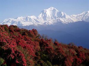
| photo_caption = The Samripe Mountains from the east camp of the peak [[X92]] | | photo_caption = The Samripe Mountains from the east camp of the peak [[X92]] | ||
| map = | | map = | ||
| map_image = [[ | | map_image = [[300px]] | ||
| map_alt = | | map_alt = | ||
| map_caption = Satellite image of the mountains. | | map_caption = Satellite image of the mountains. | ||
| Line 56: | Line 58: | ||
The '''Samripe Mountain Range''', or '''Samripes''' ([[Mahanan]]: साम्रिपे हिमालहरू, [https://en.wikipedia.org/wiki/Tibetan_script Carelitan]: ས་མོ་རི་བོ། | IPA: sæmɹipeɪ) are a large mountain range in [[Mahana]] that seperates the [[Careleon Plateau]] from the lowland areas of [[Mahana]]. The mountain range acts as a great source of scientific interest as well as tourist interest for [[Mahana]]. | The '''Samripe Mountain Range''', or '''Samripes''' ([[Mahanan]]: साम्रिपे हिमालहरू, [https://en.wikipedia.org/wiki/Tibetan_script Carelitan]: ས་མོ་རི་བོ། | IPA: sæmɹipeɪ) are a large mountain range in [[Mahana]] that seperates the [[Careleon Plateau]] from the lowland areas of [[Mahana]]. The mountain range acts as a great source of scientific interest as well as tourist interest for [[Mahana]]. | ||
The Samripe Mountains are home to some of [[Eurth]]'s tallest mountains, including one of the tallest, [[Mount Monjara]] (7,963m). The Samripe Mountains also have 25 peaks over 6,500m which, for the size of the range, is a huge amount. | |||
==Etymology== | |||
The name Samripe originates from [[Old Mahanan]], when it meant 'Snow-Sam | Heights-Ripe'. When speaking about the mountain range, the name is often shortened to the 'Samripes'. | |||
==Geography and Key Features== | |||
==Geology== | |||
==Climate== | |||
==Culture Groups== | |||
[[Category:Mahana]] | [[Category:Mahana]] | ||
{{Eurth}} | |||
Latest revision as of 11:15, 18 September 2022
| Samripe Mountains | |
|---|---|
| साम्रिपे हिमालहरू (Mahanan) ས་མོ་རི་བོ། (Carelitan) | |
 The Samripe Mountains from the east camp of the peak X92 | |
| Highest point | |
| Peak | Mount Monjara |
| Elevation | 7,963 m (26,125 ft) |
| Naming | |
| Etymology | "Mother's Peak of the World" |
| Pronunciation | sam-ree-pay |
| Geography | |
300px Satellite image of the mountains.
| |
| Location | Mahana, Orient |
| Geology | |
| Age of rock | 79 Million years |
The Samripe Mountain Range, or Samripes (Mahanan: साम्रिपे हिमालहरू, Carelitan: ས་མོ་རི་བོ། | IPA: sæmɹipeɪ) are a large mountain range in Mahana that seperates the Careleon Plateau from the lowland areas of Mahana. The mountain range acts as a great source of scientific interest as well as tourist interest for Mahana.
The Samripe Mountains are home to some of Eurth's tallest mountains, including one of the tallest, Mount Monjara (7,963m). The Samripe Mountains also have 25 peaks over 6,500m which, for the size of the range, is a huge amount.
Etymology
The name Samripe originates from Old Mahanan, when it meant 'Snow-Sam | Heights-Ripe'. When speaking about the mountain range, the name is often shortened to the 'Samripes'.