Alharu
Jump to navigation
Jump to search
 | |
| Area | 32,400,000 km2 (12,500,000 sq mi) |
|---|---|
| Demonym | Alharun |
| Countries | List of countries in Alharu |
| Languages | List of languages |
| Time zones | UTC-8 to UTC-2 |
| Largest cities | Bogd Gioro, Maurotopia, Ferrefaaierhafen, Grootwaterflakte |
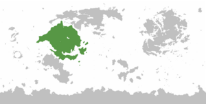
Alharu is a continent of Eurth, situated close to the continents of Argis, Thalassa and Aurelia, with which it shares a land border. Much of the Alharun coast was colonised, though parts of it did manage to resist and prosper under indigenous cultures, such as the southern highlands and the massive inland desert. Alharu can be classified as a second-world region, with an average GDP per capita of less than $25,000.
Etymology
Alharu means "hot" in Sahrabic. This is a reference to the warm temperatures in the tropical and desert regions. One alternative and controversial theory claims that the continent was actually named after Soluk explorer Álvaro or Al-Bar. (1239-1287).[citation needed]
Countries
Alharu is home to a diverse group of countries and regions.
| Arms | Flag | Country | Area (km²) |
Population | Year | Capital |
|---|---|---|---|---|---|---|
| Cashar | 512,764 | 22,412,566 | 2020 | Pavat | ||
| Esonice | 354,835 | 33,753,193 | 2018 | Maimedo | ||
| ? | Eulycea | 210,677 | ? | ? | Brisa | |
| Fulgistan | ? | 32,000,000 | 2018 | Bogd Gioro | ||
| Hemahat | 293,700 | 29,159,251 | 2019 | Khewet | ||
| ? | Kertosono | 287,907 | 28,395,261 | 2020 | Ngawi | |
| Mauridiviah | 425,000 | 34,600,000 | 2018 | Maurotopia | ||
| File:Metztli Seal.png | Metztlitlaca | 686,550 | 21,430,663 | 2019 | Altepetl Tekaken | |
| File:RhavanFlag4.png | Rhava | 240,000 | 39,000,000 | 2019 | Rhavapura | |
| San Castellino | ? | 19,530,000 | 2013 | Gazallenoa | ||
| ? | Sayf | ? | 40,800,000 | 2018 | Baghdad | |
| Variota | 380,970 | 41,910,000 | 2020 | Ferrefaaierhafen | ||
| ? | Verde | 23,262 | 10,009,200 | 2020 | Porto Verde | |
| ? | Westzeeland | ? | 28,545,000 | 2018 | Retoria |