Kotowari
People's Republic of Kotowari | |
|---|---|
 Flag | |
 Map of Kotowari | |
| Capital and largest city | Kotowari City |
| Recognised national languages | |
| Recognised regional languages | |
| Religion | |
| Demonym(s) | Kotowaran or Kotos |
| Government | Unitary Dominant-party Parliamentary Republic |
• President | Krishan Thanurajan |
• Prime-Minister | Bahira Aadhithya |
| Area | |
• | 640,456.47 km2 (247,281.63 sq mi) |
| Population | |
• 2022 estimate | 52,860,000 |
• 2018 census | 52,423,203 |
| Currency | Koto Credit (KWC) |
| Driving side | right |
| Calling code | .kw |
This article is incomplete because it is pending further input from participants, or it is a work-in-progress by one author. Please comment on this article's talk page to share your input, comments and questions. Note: To contribute to this article, you may need to seek help from the author(s) of this page. |
Kotowari (Ramil: கோட்டோவரி or Kōṭṭōvari (Kelugu: కోటవారి)), officially the People's Republic of Kotowari is a country in Oriental Europa on Eurth. Bounded by the Jasmine Sea to the north, the Rosario Sea to the west and the Menelassar Bay as well as Muladic Inland Sea to the south, it shares land borders with Tamurin to the south-east and Mahana to the south-west. It is also within the vicinity of San Ba across the Jasmine Sea.
Historically existing in the form of multiple kingdoms - including the powerful Southern Shakyan Principalities, Kotowari united in the late 17th century following the Kotowari War of Unification, The Kingdom of Kotowari was established officially, following the war, in 1677 under the rule of the Aparnan Dynasty. In 1943, Kotowari became the People's Republic of Kotowari after Queen Leyani II handed power to a parliamentary system from the monarchy, with the royal family being completely dissolved by 1983. Since 1943, Kotowari has been a democracy led by a President, managed by a Prime Minister, and governed by a unitary parliamentary constitutional republic based on the Westminster system.
They are a major power in eastern Europa and arguably Orient's biggest power following Orioni. They are a member of a number of international organisations such as the Assembled Nations, Entente of Oriental States and the Oriental Association for Regional Cooperation.
Etymology
The name Kotowari is of Shakyan origin, it stems from original city of Kadofarikh Puri - one of the original eighteen principality city-states named after the title of a Pre-reformed Juruvanic anthropomorphic diety. "Kadoft-Arikht", means Amorphous Skull. The "Kadofarikh" diety was the shapeshifting frog god of chaos, change, and adaptability. The world evolved over the course of history, and according to multiple reliable sources the name 'Kotowari' first appeared in the days of the Madurai Principality of the 13th century.
Geography

Kotowari is located in Oriental Europa,entirely in the Northern Hemisphere at the northern-most point of the Menelassar Bay facing the Jasmine Sea to the north. It borders Tamurin to it's south-west and Mahana to it's south-east, with San Ba just across the Jasmine Sea. Despite being well-known for it's flat fertile lands, mountains run across it's borders with both of it's neighbours, notably the Outer Samripes on the border to Mahana.
The Kaṭaṟkarai (coast) facing west is lush and incredibly fertile, being the sole reason for the large concentration of urban areas along the coast. It also is home to fertile valleys and rivers that run into the Periya Eri (Great Lake) in central Kotowari. There is also areas of large flatlands, suceptible to the Narope Rains which hit the region once per year. The remainder of the wests natural beauty comes from it's lush temperate forests.
Kotowari is predominantly fertile flatlands, however on both of it's southern borders, with Tamurin and Mahana it has a small mountainous area. The highest point is the Mattapunda Peak, part of the Outer Samripes, at 3,844m. The second highest point is on the border between Kotowari and Tamurin, with the Sankarandampalayam Peak at 2,993m. The Kōveṇṭrī Highlands in northern Kotowari also reaches heights up to 2,500m.
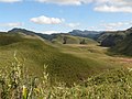
The Chengam Valley has a temperate climate.

The Periya Eri (Great Lake) in central Kotowari.

Caption
Caption


Biodiversity


_-San_Diego_Zoo-8a.jpg)

_4.jpg)


Due to the nation's varied geography and climates, Kotowari is believed to be the home of around 28,398 total animal and plant species, with around 6,190 of those being endemic to the region. It is one of the few megadiverse nations on Eurth.
Kotowari is a habitat for 8.9% of all mammal species, 14.3% of bird species, 8.9% of reptile species, 6.6% of amphibian species, 13% of fish species, and 6.3% of all flowering plant species. Almost three quarters of all the plant species in Kotowari are endemic.
Kotowari also is known for its large area of forest coverage, 68,348 km2 (26,389 sq mi) of the countries total area being forested. The majority of this area is covered by temperate forest, however tropical moist forest can be found in some areas in western Kotowari as well as temperate coniferous forest found in the Outer Samripes in the south.
Kotowari is also home to a wide range of animal species, including 181 IUCN-designated threatened animal species. Some of the most well-known animals include the national animal, the Oriental Elephant, the national aquatic animal the Nupasha river dolphin, the Koto Tiger and the Peacock. Some of Kotowari's critically endangered animals include the gharial, a type of crocodile with a long snout, and the Great Oriental bustard, due to extirpation from its former range by human inhabitants. The pervasive and ecologically devastating human encroachment of recent decades has critically endangered Kotowaran wildlife. Due to this, Kotowari signed the Animal Protection Act in 1957, opening over 50 individual wildlife parks, sanctuaries and marine sites for the protection of species.
History
Prehistory
Dravidian Migration
Shakyan Principalities

Jamine Sea City States

City states along the Jasmine Sea began to flourish after the collapse of the Shakyan Principalities in around the 6th century CE. They achieved great riches and status through the trade of rich spices and natural gold into the Pearl Road, which in return they were given other resources, knowledge and even at points slaves.[1] On top of spices and gold, Kotowari was the main source of exporting silk. This was mostly through the modern day city of Kakarla, on the inner Jamine Sea.
At the height of the Jasmine Sea City State period there was up to 15 city and port states along the Jasmine Sea, who were self-governed and traded separately from each other along the Pearl Road. The city-states had to deal with a lot of piracy during the 800s, with King Adalarasu of Chennipadu[2] succeeding in reducing piracy within the sea.
Lushanthan Empire

The Lushanthan Empire was one of the first major empires in Kotowari, beginning in the town of Lushantha, modern day Yeluru Region. It began to expand quickly and by the late 1000s was a regional power, owning a majority of what is present day Kotowari as well as northern parts of Tamurin as well as some islands in the Jasmine Sea. It was in 1109 that it was pronounced an "Empire" with it's holding of an enclave in the peninsula north of Kotowari. The empire was run in a system called the "Six Tables" which in essence was six councils elected by the Emperor which would make decisions for the empire. All six of the major cities at the time had a table, Kiḻakkin (Kotowari City), Bankra, Kenil, Feni, Jashore and Muladi. Quickly the Lushanthan Empire became a regional power in the Orient, taking over from the Jasmine Sea City States and becoming an important connector in the Pearl Road, along the Menelassar as well as Jasmine Sea.

The most famous emperor of the Lushanthan Empire was Aanantharuban, who ruled over the empire from 1194 to 1220. He was known for his rapid reforms as well as modernisation of the agricultural industry which he played a large part in. However Aanantharuban is most known for being the first leader to condone and introduce Hinduism to the region, with the religion spreading rapidly across the peninsula from the early 13th century. This made him one of the nations most influential leaders despite his harsh methods of spreading the Hindu religion across the peninsula.
Toward the end of the 13th century the Lushanthan Empire became weak due to inward corruption as well as the Jasmine Age of Piracy which heavily affected cities such as Bankra and many along the Jasmine Sea. Pressure began to turn toward the government and the Six Tables as little was seen to be done to stop the pirate invasions of Lushantha. This lead to an eventual collapse of the empire under Empress Jeyatheepa.
Vinovian Era
The "Vinovian Era" is in reference to the period of time when the power vacuum left by the collapse of the Lushanthan Empire had not been filled in Kotowari. During this period, a number of city-states and small kingdoms existed on the peninsula, notably kingdoms such as Bankra and Jashoria. These Kingdoms initially began as weak and small, with little amounts of organisation or structure. This lead to foreign powers taking advantage of the ex-Lushanthan territory, with nations such as Mahana and Tamirini gaining land that was owned by the Lushanthans. As well as this, a well known pirate state appeared on the Jasmine Sea around the modern cities of Yeluru and Rajampalli.
Many of the kingdoms and city-states co-operated with each other, having trade agreements and defensive alliances. By the end of the 15th century two of the many kingdoms and states began to stand out on the world stage, the states of Bankra and Jashore which had both become powerhouses in their regions. It was at this time, around the early 1600s, that Kotowari's economy had begun to decline, as the majority of the peninsula was excluded from the Pearl Road slave trade.

During this era Kotowari had many great explorers and traders, including Visvash Rao who was the first Oriental to make it to the western world, travelling from Bankra and arriving at the coast of Alharu, modern day Ketek Peninsula, in 1667.
Unification
The birth of the Kingdom of Kotowari was the result of efforts by Koto nationalists and monarchists loyal to the House of Nikasha to establish a united kingdom encompassing the entire Koto Peninsula. Following the Conference of Kenil in 1798, the Kotowari unification movement, or the Oruṅkiṇaippu, gained a lot of support.
- Similar situation to the Italian Unification
Modern History
Contemporary History
- Look into Wari culture for similar climate.
- Consider relationship with the Pearl Road network, other Jasmine Sea countries, neighbouring Mahana / Tamurin.
- Joined the Entente of Oriental States as an observer in December 2017.
Politics

_(cropped).jpg)

Kotowari is a de jure representative democracy under its constitution, with a Westminster-style unitary parliamentary republic that has universal suffrage. The head of government in Kotowari is the Prime-Minister who, every five years, is invited to form a government in Kotowari City.
Executive Branch
The government of Kotowari is overseen by the cabinet, which is headed by the Prime-Minister of Kotowari. The tenure of a government in Kotowari is five years. The Civil Service assists the cabinet in running Kotowari's government. Recruitment into the Civil Service is by public examination. The President of Kotowari is the ceremonial Head of State and the powers held by the Head of State include signing bills passed by parliament and making them law. The President is elected by the parliament at the tenure every five years. The President also serves as Supreme Commander of the Kotowari Armed Forces and the chancellor of all universities.
The current Prime-Minister of Kotowari is Bahira Aadhithya, chair of the leading Kotowari Ramillian Party [4]. The current President is Krishan Thanurajan, apart of the same party as Bahira Aadhithya. Both of the leaders of Kotowari are known to be Orientalists, believing in regional cooperation and local relations, similarly to the government in Tamurin.
Legislative Branch
The Supreme Court of Kotowari is the highest form of court in the land, followed by the High Court and Appellate Divisions. The head of judiciary is the Chief Justice of Kotowari.
Kotowari's legal system is based on common law and its principal source of laws are acts of Parliament. The Parliament is made up of 350 members, with tight coalitions. The Kotowari Ramillian Party make up the majority of the seats in most elections, being the most popular party over the last fifty years, however other major parties include the Kotowari Workers Party (KWP) and the Eastern Kelugu League (EKL).
| Name | Ideology | Leader | Electoral results | Seats in parliament | Coalition | |
|---|---|---|---|---|---|---|
| Ramillian Party | Center-Left | Ms. Bahira Aadhithya | 86.29% | 302 / 350
|
Coalition | |
| Kotowari Workers Party | Far-Left Politics | Mr Rahman Akula | 7.4% | 26 / 350
|
Opposition | |
| Kotowari Nationalist Party | Centre-Right/Right Wing | Mr Pradeep Thota | 2% | 7 / 350
|
Opposition | |
Foreign Relations
Kotowari is a member of a number of international organisations including the Entente of Oriental States, the Assembled Nations, the Oriental Association for Regional Cooperation (OARC) and formerly also the Europan Commercial Alliance. Close relations with their neighbours such as Tamur and Mekabiri have lead to their continued joining of international organisations, as well as the Orientalist beliefs of the leaders of the nation which make them move toward local cooperation in organisations such as the OARC.
Administrative Divisions
| Regions of Kotowari | ||||||||||||||||||||||||||||||||||||||||||||||||||||||||||||||||||||||
|---|---|---|---|---|---|---|---|---|---|---|---|---|---|---|---|---|---|---|---|---|---|---|---|---|---|---|---|---|---|---|---|---|---|---|---|---|---|---|---|---|---|---|---|---|---|---|---|---|---|---|---|---|---|---|---|---|---|---|---|---|---|---|---|---|---|---|---|---|---|---|

Chennipadu Periya Yeluru Bankra Jashoria Kallavala Ghoksila Kabirhat Muladi Nuruwalia Feni Eliyathur |
Table of the regions | |||||||||||||||||||||||||||||||||||||||||||||||||||||||||||||||||||||
| ||||||||||||||||||||||||||||||||||||||||||||||||||||||||||||||||||||||


Cities
Largest cities or towns in Kotowari
National Census 2018 | |||||||||
|---|---|---|---|---|---|---|---|---|---|
| Rank | Region | Pop. | Rank | Region | Pop. | ||||
 Kotowari City  Bankra |
1 | Kotowari City | Capital Territory of Kotowari City | 10,514,000 (Metro) | 11 | Yeluru | Yeluru Region | 900,495 |  Jashore  Muladi |
| 2 | Bankra | Bankra Region | 6,794,303 (Metro) | 12 | Kakarla | Yeluru Region | 849,331 | ||
| 3 | Jashore | Jashoria | 4,334,494 | 13 | Rajampet | Ghoksila Region | 810,483 | ||
| 4 | Muladi | Muladi District Region | 2,885,446 | 14 | Rajampalli | Yeluru Region | 781,303 | ||
| 5 | Kenil | Nuruwalia Capital Region | 2,577,309 | 15 | Shrimusman | Eliyathur Region | 646,394 | ||
| 6 | Feni | Feni District Region | 2,003,495 | 16 | Manmalai | Periya Region | 600,374 | ||
| 7 | Kabirhat | Kabirhat Region | 1,778,436 | 17 | Ghoksila | Kallavala Region | 559,431 | ||
| 8 | Chennipadu | Chennipadu Region | 995,495 | 18 | Kallavala | Kallavala Region | 349,391 | ||
| 9 | Kadathur | Eliyathur Region | 977,486 | 19 | Padmatpati | Capital Territory of Kotowari City | 219,394 | ||
| 10 | Vadalure | Eliyathur Region | 943,394 | 20 | Munjanur | Eliyathur Region | 111,129 | ||

Economy
Employment
Exports
Energy
Transport
Media
Currency
Demographics
Ethnic Groups

Ramilliam bharatanatyam dancers.

A traditional Ramillian wedding.

Kelugu woman wearing a traditional dress.

A traditional Kelugu celebration.
.jpg)


Cultures
Literature
Visual Arts
Music
Cuisine
National Dish
The national dish of Kotowari comes in three main courses, the sṭārṭar (starter), mukkiya pāṭaneṟi (main course) and iṉippu (dessert). Each course is made up of traditional Ramillian cuisine, with the national dish being known as "Ti kirēṭ cāppāṭu". Ti kirēṭ cāppāṭu can be found in most traditional restaurants and in tourist areas in the country.
The sṭārṭar consists of dosa, a thin pancake made of fermented batter of lentils & rice. Dosa is prepared and made using a mixture of rice and black or green gram that has been soaked in water is ground finely to form a batter. Some add a bit of soaked fenugreek seeds. The proportion of rice to lentils is generally 3:1 or 4:1. The batter is allowed to ferment overnight, before being mixed with water to get the desired consistency. The batter is then ladled onto a hot tava or griddle greased with oil or ghee. It is spread out with the base of a ladle or bowl to form a pancake. It can be made either to be thick like a pancake, or thin and crispy. A dosa is served hot, either folded in half or rolled like a wrap. It is usually served with chutney and sambar. The mixture of black grams and rice can be replaced with highly refined wheat flour or semolina.
The mukkiya pāṭaneṟi is made up of kozhukattai, a popular dumpling, as well as chutney and appam, a type of pancake. The kozhukattai is prepared by mixing grated coconut with jaggery syrup, placing it inside dumplings of rice flour, and steaming the dumplings. Ghee, cardamom, finely ground roasted rice flour etc. may be added to enhance the taste and flavour of the filling. In Kerala, a variant of kozhukattai made with atta flour (instead of rice flour) and grated coconut is a staple breakfast among some groups. The appam is usually prepared in different ways depending on the location, with it being more sweet in northern Kotowari and savoury in the south.
The iṉippu course simply consists of Koppai, a famous ice-cream from Kotowari.
Sport
References
- ↑ "Slavery existed for the first time in the Kotowaran City States, with slaves from Azania being taken." (PDF) Retrieved 26th June 2022
- ↑ "Chennipadu was the largest and most prosporous of the Jasmine Sea City-States" (PDF) Retrieved 5th July 2022
- ↑ "Constructed painting of Aanantharuban from 1889" (PDF) Retrieved 18th July 2022
- ↑ "The Ramillian Party" - "Close in views to the Awami League, being centre left".
| History | |||||||||
|---|---|---|---|---|---|---|---|---|---|
| Continents & 132 Countries | |||||||||
| Geography |
| ||||||||
| Organisations |
| ||||||||
| Politics | |||||||||
| Law | |||||||||
| Military | |||||||||
| Economics | |||||||||
| Culture | |||||||||
| Sports | |||||||||