Europa (continent): Difference between revisions
m (→Geography) |
m (Maltropia moved page Europa to Europa (continent) without leaving a redirect: Disambiguating as non-primary usage) |
(No difference)
| |
Revision as of 19:19, 29 July 2020
 | |
| Area | 40,500,000 km2 (15,600,000 sq mi) |
|---|---|
| Demonym | Europan |
| Countries | List of countries |
| Languages | List of languages |
| Time zones | UTC+5 to UTC+10 |
| Largest cities | |
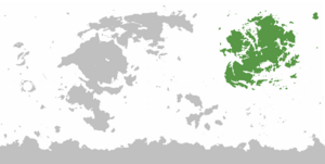
Europa is a continent of Eurth bordered by the Argic Ocean to the north, the Adlantic Ocean to the west and the Oriental Ocean to the south and east. The closest other continent is Argis, across the northern polar region.
Etymology
Europa means "land of the father" in Proto-Europan.
Geography
The continent is situated entirely in the eastern hemisphere, and most mostly in the northern hemisphere. Only a part of Jilderen and the Meteorolan archipelago extend south across the Equator. The maritime borders consist of the Argic Ocean to the north, the Adlantic Ocean to the west and the Oriental Ocean to the south and east. The closest continents are Argis across the northern polar region, Thalassa to the east, and Marenesia to the south.
The continent of Europa is divided into several important regions, especially the large peninsulas separated from the main continental landmass by geographical features.
- Occident in the northwest, largely based on remains of the classical Aroman Empire. (Pseudo-Latin cultures)
- Burania (Aroman: north) in the northeast with colder climates. Historically, the interior is home to nomadic steppe cultures. Along the coasts there live seafaring culture. (Pseudo-Anglo-Germano-Russo-Fennoscandian cultures)
- Orient (Aroman: rising) in the east and southeast is focused on trade between kingdoms and archipelago (Pseudo-Sino-Indian cultures)
- Amutia (from Aroman Αμμουδιά meaning sand sea) is the large central desert, hammered by the San. Its fields of dunes are broken by gravel plains and volcanic outcrops, shimmering under hazing heat. This makes it difficult to travel from northern to southern subcontinents. The terrain is dotted with oases. Nevertheless, the Amutian desert has been described as "army devouring". But there is water to be found underground, trapped in depressions or beneath the wadis where the occasional flash flood rumbles by. It is around these oases and spring that desert people settled and farmed. (Mixed cultures)
- Azania in the southwest. According to early Aroman sources, the Azanian people possessed arguably the finest archers but didn't favour discipline or an organised command hierarchy. Their patron animal was the leopard, which was depicted exclusively on royal banners. Two important subregions are:
- Memopotamia in the southwest has a long and difficult history, with countries such as Hakenium, Mahdah, Sa Hara (Pseudo-Semetic cultures)
- Zongla (Aroman: jungle) in the far southwest, with countries such as Afropa, Jilderen, Dragonryders (Pseudo-African cultures)
WIP
- Mountains, peaks
- Climate zones
History
WIP:
- integrate parts of Swahili naval history for Azania/Zongla.[1]
Countries
The list below includes some of the nation falling even partially under any of the various common definitions of Europa, geographic or political.
- ↑ The Swahili Culture - 0 to 1500 CE - African History Documentary by Stefan Milo (26 October 2019)
