Mahana
Federal Democratic Republic of Mahana संघीय लोकतान्त्रिक गणतन्त्र महान Saṅghīya lōkatāntrika gaṇatantra Mahāna (Mahanan) | |
|---|---|
Coat of arms
| |
Motto: "Adbhuta pahāḍī rājya" "Bound by Democracy" | |
Anthem: Shreeman Gambhir | |
  | |
| Largest city | Jutpandi |
| Official languages | Mahanan |
| Recognised regional languages | Sanpujri Gurung |
| Ethnic groups (2012)National Census | 16.6% Sheshtri 12.2% Gaimreti 7.1% Mai 6.6% Tamang 5.8% Jhimpe 5% Jamuni 4.4% Butwali 4% Koshi 2.3% Kiralimbu 2% Pashimari 1.5% Shivalaya 21.93% Other Ethnic Groups |
| Religion | 81.3% Gaism 9.0% Buddhism 4.4% Hinduism 3.1% Kirant 1.4% Islam 0.5% Christianity 0.5% Prakriti 0.3% Others |
| Government | Federal parliamentary republic |
• Prime-Minister | Ranju Bastola |
• President | Bina Sharma |
| Legislature | Federal Parliament |
| National Assembly | |
| House of Representatives | |
| Area | |
• | 241,600 km2 (93,300 sq mi) |
| Population | |
• 2021 estimate | 29,800,00 |
• 2012 census | 29,686,017 |
| GDP (PPP) | 2021 estimate |
• Total | $127.22 billion |
• Per capita | $1,867 |
| GDP (nominal) | 2021 estimate |
• Total | $36.084 billion |
| Gini | 32.6 medium |
| Currency | Mahanan Rupee |
| Time zone | UTC+8 |
| Driving side | left |
| Calling code | +989 |

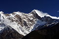
Mahana (Mahanan: महान or Mahāna|IPA: mæhˈɑːnə (![]() listen), officially the Federal Democratic Republic of Mahana is a country in Europa, more specifically the sub-continent of Orient, which consists of 29 million people. Mahana is bordered by Kotowari to the north and Mekabiri to the south. The capital city is Jutpandi but other large cities include Ghobari, Battagara and Veydu. The most notable feature of Mahana is the Samripe Mountain Range, one of the largest on Eurth, and specifically Mount Monjara, standing at 7,963m tall. The most followed religion in Gaism, a religion centred around the worship of the bovine God of Kuladara. Mahana is made up of a huge amount of differing ethnic peoples, including the Sheshtri, Gaimreti and the Mais. The name 'Mahana' literally translates to 'Great' in the native language.
listen), officially the Federal Democratic Republic of Mahana is a country in Europa, more specifically the sub-continent of Orient, which consists of 29 million people. Mahana is bordered by Kotowari to the north and Mekabiri to the south. The capital city is Jutpandi but other large cities include Ghobari, Battagara and Veydu. The most notable feature of Mahana is the Samripe Mountain Range, one of the largest on Eurth, and specifically Mount Monjara, standing at 7,963m tall. The most followed religion in Gaism, a religion centred around the worship of the bovine God of Kuladara. Mahana is made up of a huge amount of differing ethnic peoples, including the Sheshtri, Gaimreti and the Mais. The name 'Mahana' literally translates to 'Great' in the native language.
Mahana, despite historically being isolationist, currently have positive relations with a majority of Eurths countries, being a member of many international organisations such as X, X and the Assembled Nations. The nation has been a democracy since the Mahanan Civil War of the early 1990s, which overthrew the Monarchy in Mahana. The current Prime-Minister is Ranju Bastola and President is Bina Sharma. The current Queen is Sharma II, however the title is more of a 'show title' in present day.
Etymology
The term 'Mahana' first appeared upon initial unification in the 13th century, during the Sapkota Dynasty. In Old Mahanan (पुरानो महन्त लिपि) the word is thought to originally have meant 'Land of the Great Kings'. However the legitimacy of this claim is questioned and the true origins of the name are unknown, thought to be by some to originate from the Ancient Oharic language.
Geography
Mahana is an oddly shaped country, with a fairly square shape but with two similar looking panhandles in the north and south. Mahana's key geographic features originate from the Europan Plates 79 million years ago, the Samripe Mountain Range. The rising of these plates also blocked the paths of rivers creating large lakes, which only broke through as late as 100,000 years ago, creating fertile valleys in the middle hills like the Ghobari Valley. In the south-eastern area, known as the lowlands, consists of fields perfect for rice harvesting as well as land for agriculture. On the west side of the Samripes is the Careleon Plateau, an area of relatively low relief and uninhabitable lands. Despite this many ethnic groups call the plateau home.
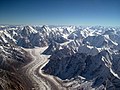
Mahana is seperated into three physiographic belts, known as Ripal-Juhada-Patu. Ripal is the name for the lowlands region which is home to the majority of Mahana's agriculture, which also borders the Bay of Bhuram. This area contains the lowest areas in all of Mahana. Juhada is the region that houses the Samripe Mountain Range, as well as Mount Monjara. This area is incredibly mountainous, with heights just shy of 8,000m far from uncommon. The Patu region is a large plateau, home to hunter-gatherers and native groups. The region can be harsh and production of goods is hard in areas, however in the eastern-most regions of Patu is the cities of Jutpandi and Battagara.
Biodiversity
Mahana contains a disproportionally large diversity in climates, plants and animals in relativity to it's size. Mahana has notable biocultural diversity due to it's varied environments. The huge, dramatic differences in elevation from the Inner Careleon Plateau as low as 64 metres above sea level to the peak of Mount Monjara at 7,963 metres above sea level. The Ripal Region (east) is home to the richest biodiversity due to the conditions, with the majority of the Patu and Juhada regions being too harsh to support large amounts of biodiversity. Mahana is home to 7.3% of all mammals, 15.4% of all birds, 2.0% of reptiles, 5.3% of all amphibians, 2.2% of fish species, 6.7% of all butterfly species, 0.5% of all moth species and 1.2 of all spider species.
Mahana's forest coverage is 64.3% of the total area. In the Ripal region you can find tropical evergreen forests, subtropical forests as well as temperate broadleaf and mixed forests. In the Juhada region there is widespread pine forests and subtropical pine forests.
Image Gallery
(Samripe Mountains 1)

(Samripe Mountains 2)
(Samripe Mountains 3)

(Careleon Plateau 1)

(Careleon Plateau 2)

(Careleon Plateau 3)

(Lowlands 1)

(Lowlands 2)

(Lowlands 3)


.jpg)


History
Ancient Mahana
Prehistory
.jpg)
The first evidence of human presence in Mahana can be dated to around 70,000 years ago from Azania where they evolved. The earliest modern humans likely began to appear closer to 55,000 years ago. The oldest archaelogical evidence of human settlement in Mahana dates to even later, around 40,000 years ago.
After 7,000 BCE evidence of early animal domestication, storage of agricultural surplus as well as permanent construction was found. Over time these developed into the early Ghobari Valley Civilisation, evidence for this can be found in the Mugarati and Plunbit sites in the south of Mahana. Mesolithic and even palaeolithic evidence has also been found in the Bhetwal Province. It is believed, because of this, that Mahana and areas surrounding was one of the first areas settled by humans in Orient. By around 4,000 BC the earliest Patuan peoples arrived to the Careleon Plateau, which was not yet a desert-plateau at the time. The origins of these people is unknown, however by most it is believed they must have originated from central Europa, as well as evidence of this in DNA. It was also around 4,000 BC when the first mentions of very early Gaism appeared in the Ghobari Valley.

Around the year 3,200 BC it is believed that the early Mardri peoples developed from the Ghobari Valley Civilisation and spread into the Patu and Ripal regions, establishing early city civilisations. This is known due to the fact it was recognised by early Gai scripts. The separation of the peoples in Mahana lead to huge ethnic diversity, with languages used between the regions being completely separate. The eldest established dynasty in Mahana is believed to be the Jhuapi Punha Dynasty, which was established very close to the modern capital of Jutpandi. It was also with this dynasty that the language of Kulura was established, which is believed to be the earliest ancestor language to modern Mahanan.
The Carelitan language also began developing in the Careleon Plateau, evidence suggests, around the year 2,900BC. Mahana also received small populations from the early Shakyan civilisation to the north around a similar time. Towards the end of the Veyduan Period (1,300BCE) Mahana had been mentioned on multiple occasions throughout Gai texts as well as multiple Hindu texts. The Topal Gura Dynasty began being mentioned in texts, being the second dynasty named in religious texts. The Topal Dynasty founded the ancient city of Nupakara, modern-day Ghobari. Evidence suggests there was large scale infighting between the Topal Gura Dynasty and the Jhuapi Punha Dynasty in western Mahana.
Trade between dynasties and kingdoms within Mahana began to boom around 900BC with all kinds of agriculture and valuable items being passed between the kingdoms and dynasties. Around 600BC, further small kingdoms appear in the eastern regions and around the Mahanan Lowlands. Most of these would be cleared off in 500BC as the Shakyans arrive and occupy a majority of the lowland region. The Shakyans managed to push back the Topal dynasty and occupy a majority of modern western and southern Mahana. From the Shakyan Dynasty arose a local prince named Vuatama Buddha who would become a founder of the Buddhism religion in Mahana.
- Prehistory — (WIP. Inspiration can be found in this reference of Meluhha. This could also be the coastal area southeast of you. Several nearby places all begin with the letter "M": Miiros, Mekabiri, Mahana, Mantella.)
- 100s BCE — (WIP. Integration with the Pearl Road trade network. Borrow elements from Shakya?)
- (WIP. Figure out a shared heritage with the neighbouring countries.)
Medieval Mahana
- 1000s — Mahana was established officially in the 11th century as Emperor Chamrel lead the ancient Khad peoples down the Ghobari valley and into the area of modern day Jutpandi. These early peoples were believed to have been the first to practise Gaism in the region, as well as founding the ancient city of Vaddkewatta, which is situated in modern Jutpandi.
- 1100s — These people were led by the Chamrel Dynasty until the late 12th century, when they were deposed following the Mahanan Civil War, putting the Sapkota Dynasty into power.
- 1200s — It was in the 13th century when they doubled the amount of land they occupied, roughly to the modern borders, under the Sapkota Dynasty and notably Emperor Guragai.
- 1280s — It was in the very late 13th century in which Emperor Rabi introduced the caste system to Mahana. Mahana's downfall was upon the death of Emperor Jhapali, his three sons disagreed on land inheritance, resulting in the land being split into three.
- 1350s — (WIP. Expect some coastal raids during the Orinese colonial period. This would work well with the downfall you described above. A period of internal instability would help explain an external threat.)
Mahanan Unification
- 1700s — Mahana remained in this way until it was united in the 18th century by a man named Balraj Singh who lead one of the three ununified states, Jalanpathur.
- 1875-1900 — The current borders of the nation were drawn up in the late 1800s, and have remained stable since.
Contemporary Mahana
- 1900s — In the early 1900s, a man named Sudip Subba managed to successfully take power, forcing the monarch to become a secondary power and announcing himself as supreme leader or Subban. Afterward, the kings of Mahana were only figureheads and the Subban held the real power.
- 1943 — However, in the year 1943, the Gayin (Head of the Gaism religion) stated that the Subban was not the rightful leader of Mahana at any given time, restoring power back to the king, with the Subban position fading following this.
- 1992 — The Mahanan Civil War of the early 1990s removed all power from the Monarch, with the role only being a 'show title'. Establishment of the current Federal Democratic Republic of Mahana.
- 2021 — Today, Mahana remains a poor country, with most working in farming. However, Mahana is seen to have great tourist potential, with 26 million visitors in 2020. They are exporters of materials such as plastics and soft metals, as well as tea and other goods.
Politics
Mahana is a parliamentary republic with a multi-party system. The three parties that are recognised by the federal parliament; the Mahanan Congress (MC), Mahanan Red Workers Party (MRWP) and the Simatra Jima Party (SJP). The MRWP is considered leftist, the Mahanan Congress is considered centrist and the SJP considered right leaning. Since the establishment of the parliamentary system the Mahanan Congress has been the most sucessfull, holding the majority of seats during each election so far, only being rivalled by the MRWP in the early 2000s and mid 2010s. Previous to the establishment of Mahana's parliamentary system, they had a 'Parliamentary Monarchy', however most historians would consider it to have been an absolute monarchy due to the fact each of the parties were owned by the monarch, prior to the early 1990s. Some examples of parties from this time period include the Crown Juti Party and the Democratic People's Party.
Government
Administrative Divisions
| Province | Capital | Governor | Chief Minister | Districts | Area (km2) |
Population (2011) |
Density (people/km2) |
Human Development Index | Map |
|---|---|---|---|---|---|---|---|---|---|
| Nuragara Province | Jutpandi | Palash Piya | Rajendra Ra | 18 | X | 8,334,230 | X | 0.578 | File:Screenshot 2022-01-17 185714.png |
| Sadheshi Province | Veydu | Hari Hankar | Lalbabu Raut | 8 | X | 5,132,494 | X | 0.472 | File:Screenshot 2022-01-17 191738.png |
| Banurati Province | Ghanashyam | Chandra Shoama | Prasad Pandey | 10 | X | 6,493,329 | X | 0.488 | File:Screenshot 2022-01-17 192311.png |
| Thubten Province | Sherabi | Tempa Pakshi | Paldon Sambhota | 6 | X | 2,403,757 | X | 0.428 | File:Screenshot 2022-01-17 192854.png |
| Paranani Province | Ghobari | Ekaraj Verma | Bichitra Chalise | 13 | X | 3,199,272 | X | 0.519 | File:Screenshot 2022-01-17 193210.png |
| Nyandak Province | Lhakpa | Wangyal Dramuktsang | Chodak Gonpo | 10 | X | 1,570,418 | X | 0.469 | File:Screenshot 2022-01-17 193909.png |
| Bhetwal Province | Godapyuri | Ganga Prasad Yadav | Nepuchi Bhatta | 9 | X | 2,552,517 | X | 0.478 | File:Screenshot 2022-01-17 202048.png |
| Mahana | Jutpandi | President Bina Sharma |
Prime Minister Ranju Bastola |
74 | X | 29,686,017 | X | 0.581 | File:Screenshot 2022-01-17 202516.png |
Military and Intelligence
The military in Mahana is handled by the Mahanan Ministry of Defence. The military expenditure for 2017 was 431 million, around 1.5% of the countries GDP. An almost exclusively ground force of soldiers, the Mahanan Army numbers at less than one hundred and fifty thousand. The military own few aircraft, mainly helicopters used in search and rescue, usually in the Samripes. The military is lead by the Head of Defence, currently Kusum Paudel. The Directorate of Military Intelligence is under the army in Mahana; the National Intelligence Agency acts seperately, however. The military in Mahana is primarly used for search and rescue, anti-poaching in national parks and counterinsurgency. There are no discriminatory policies in joining the army, and haven't been since 2006 when women were allowed to enlist, however in order to join one must complete the harsh Pugati Test
Economy
Mahana's GDP (Gross Domestic Product) for 2021 was $36.084 billion with an annual growth rate calculated at 4.9% in 2021, which is expected to rise to 6.5% by 2025. Mahana could be considered to be one of the fastest growing economies in Europa, however with one of the lowest GDP nominal per capita.

The 17.9-million-worker Mahanan Worker Force is one of the largest on Eurth. Primary work sectors make up to 34.2% of GDP, the secondary 14.3% and the tertiary 51.5%. Major agricultural products include tobacco, potato, oilseed, jute, cereal (barley, maize, millet, paddy and wheat) and milk. Major industries include tourism, cigarettes, textiles, cementing, rice, sugar and bricks. Mahana's international trade expanded greatly in the 1990s as a complete democratic system was restored. Mahana's economy was ruined in the 1990s following the Mahanan Civil War. Major exports of Mahana include leather, carpet, medicinal herbs and paper product. Major imports of Mahana include machinery, raw materials, plastic, tea, electrical and electronic devices, gold and semi-finished goods.

In recent years Mahana has made great progress in poverty reduction as well as reducing the gap in development. In 2010 Mahana was below the International Poverty Line (AIA$1.90 per person per day) from 17.3% to just 9.9% in 2019, however vulnerability still remains high as almost 34% of the population living on between $1.90 and $3.45 per day. However, Mahana has made great improvements to sectors such as infant mortality, nutrition, electricity and access to internet. On the current trajectory, Mahana is set to eliminate poverty within the next 35 years. Mahana's agricultural sector comes under great risk as during the months June-September the Narope Rains cause floods in the lowland regions, which Mahana relies on for a lot of the farming. As of 2014, Agriculture employs 76% of the workforce, services 18%, and manufacturing and craft-based industry 6%.
Besides being almost landlocked, rugged and harsh geography, poor infrastructure, ethnic tension and lack of natural resources as well as long lasting civil war tensions, the post-1990 government has done a good job stabilising the country.
Tourism
Tourism is the largest and fastest-growing industry in Mahana, employing more than 1.5 million people. The industry also contributes to around 9.7% of Mahana's GDP. The number of international visitors to Mahana surpassed 1 million for the first time in 2012, with that number increasing each year (statistic not including those who travel on the road from neighbouring countries). Premier destinations in Mahana include the Sheshtri National Park (Home to Mount Monjara), the seaside city of Ghanashyam, the cultural city of Jutpandi, the Pashni National Park and the Ghobari Valley.
Foreign Employment
Today Mahana remains a poor country, with most working in farming. However, Mahana is seen to have great tourist potential with 26 million visitors in 2020. They are exporters of materials such as plastics and soft metals as well as tea and other goods.
(WIP. Currency: Mahanan Rupee.)
Culture
(WIP. Based heavily on Nepali and Northern Indian culture.[1])
Ethnic Groups


Mahana is one of Eurths most ethnically diverse nations, with tens of different ethnic groups of notable size making up the modern day nation. The reason for this is the historic separation and isolationism meant that different peoples grew slightly different from each other, forming the modern ethnic makeup of Mahana. A huge majority of the people living in Mahana are native groups, an estimated 98.7% of their population in 2021.
The largest ethnic group in Mahana is the Sheshtri peoples, part of the Mardri ethnic family, alongside the Jamuni,Butwali,Pashimari, Mai and Shivalaya, as well as other smaller groups. These groups are most often found in the Outer Careleon Plateau as well as the lowlands Ripal region. These people are closer to the regular Orient ethnic groups as they have had more interaction with the outer world than the Patuan family of ethnic groups. The Patuan Ethnic Family originates in the Patu region of Mahana, specifically the Inner Careleon Plateau, however some members of the family can be found as far east as the Samripes. Some members of the Patuan Family include the Gaimreti,Koshi,Tamang,Jhimpe and Kiralimbu. The main difference between the Patuan and Mardri families, besides general appearance, is the language. The Mardri peoples speak Mahanan and the Patuans often speak the Carelitan language, however Mahanan has become the primary language with almost all citizens speaking the language.
Religion
Mahana is the holy land of the religion of Gaism, founded in the Ghobari Valley. For this reason, the religion is the most followed in Mahana.
Cuisine
Arts
References
- ↑ Vision statement of Mahana (11 December 2021)
| History | |||||||||
|---|---|---|---|---|---|---|---|---|---|
| Continents & 133 Countries | |||||||||
| Geography |
| ||||||||
| Organisations |
| ||||||||
| Politics | |||||||||
| Law | |||||||||
| Military | |||||||||
| Economics | |||||||||
| Culture | |||||||||
| Sports | |||||||||